2 DaysCouples7 Stops

San Francisco Bay Area (day trips), California

2-Day Itinerary for Couples

โ€œRedwoods, Ridgelines & Restless Surf: Two Days North of the Bridgeโ€

Redwoods, Ridgelines & Restless Surf: Two Days North of the Bridge

North of the Golden Gate, fog moves like a living thing through redwood cathedrals and wind-scoured ridgelines drop straight into a restless Pacific. This is a two-day arc built for slow mornings, long views, and dinners lingered over โ€” the kind of trip where the drive itself becomes part of the romance.

At a Glance

Climate & Weather
Spring brings mild days (55โ€“65ยฐF), frequent morning fog that burns off by midday, and the real possibility of rain showers โ€” pack waterproof layers, a warm jacket for ridge winds, and sturdy shoes for muddy trail sections. Wildflowers are in bloom along coastal bluffs, a lovely bonus for photography.
Getting Around
A rental car is essential โ€” this itinerary covers two separate clusters connected only by scenic, winding roads with no meaningful transit option. Expect 45โ€“90 minute drives between destinations and always check Muir Woods parking reservation requirements in advance.
Budget
Budget roughly $150โ€“220 per day for two, covering park entrance/parking fees, casual lunches, and one upscale dinner; add more if you opt for wine pairings or a splurge tasting menu.
Safety
Both days are low-risk but involve real coastal and mountain terrain โ€” stay on marked trails, especially near cliff edges at Point Reyes and rocky outcrops at Stinson Beach, and treat sudden fog as a cue to slow down, not push forward. Roads are winding with limited shoulder in places, so allow extra time and drive cautiously, particularly on Highway 1.
Connectivity
Cell coverage is spotty to nonexistent in redwood groves and along remote stretches of Highway 1 and Point Reyes' outer peninsula โ€” download offline maps before departing San Francisco and let someone know your rough route.
Local Tips
Arrive at trailheads by 7:30โ€“8am to beat both parking crunches and crowds โ€” this matters most at Muir Woods and Point Reyes on weekends; reserve Muir Woods parking online well ahead, as it sells out; and pack a thermos of coffee, since cafรฉs in these small coastal towns often don't open until 8am.

Highlights

  • Sunrise solitude atop Mount Tamalpais before the crowds arrive
  • Walking hand-in-hand beneath 2,000-year-old redwoods in Muir Woods
  • Windswept cliffside views at Point Reyes' Chimney Rock
  • Golden hour at Stinson Beach with sand underfoot and waves crashing
  • Tule elk sightings along the wild spine of Tomales Point
  • Intimate coastal dining with ocean views and unhurried pacing

Day-by-Day Plan

Mountain & Forest

Day 1: Ridgelines and Redwood Silence

A gentle first day tracing Mount Tamalpais' summit views and Muir Woods' hushed groves, roughly 2.5 miles of easy-to-moderate walking with low cognitive load for settling into Bay Area rhythm.

Wear
Layers are essential โ€” a warm base layer, a packable rain shell, and broken-in walking shoes with grip for damp trail sections; bring a light scarf or beanie for the summit wind.
Budget
$140โ€“180 for two (parking, coffee, lunch, dinner)
7:30 AM - 10:00 AM
Mount Tamalpais ยท morning ยท 150 min ยท Marin Headlands & Mount Tamalpais

Arrive while the fog is still deciding whether to lift, and you'll have the East Peak overlook nearly to yourselves โ€” just wind, the resin scent of Douglas fir, and a view that stretches from the Sierra to the Pacific. By 9am, the main parking area starts filling with weekend hikers, so this early window is the quiet, romantic one. A short walk from the summit parking gets you to Pantoll Ranger Station's overlook, ideal for a slow, wordless moment together.

Mount Tamalpais
Banks, Charles Eugene, 1852-1932 Read, Opie Percival, 1852-1939 / wikimedia (Public domain)
Shoot from the East Peak summit parking area right at sunrise, when low light rakes across the ridgelines before fog burns off.
Paved overlooks near the summit parking are accessible, but most trail viewpoints require uneven, unpaved terrain.
35 min drive โ€” A winding descent through eucalyptus-scented switchbacks, radio off, windows cracked to catch the changing air.
10:45 AM - 12:45 PM
Muir Woods (early reservation) ยท midday ยท 120 min ยท Muir Woods & Mill Valley

Descend from open ridgeline into hushed, cathedral-dark groves โ€” the temperature drops, sound softens, and 2,000-year-old redwoods rise around you like columns in a living nave. This is the kind of quiet that couples remember: hold hands along the Main Trail's twin redwoods, and don't rush the meadow clearing near the end, where filtered light often breaks through just right for photos. Reservations are mandatory here, so this stop only works if booked ahead.

Muir Woods (early reservation)
Ontario. Royal Commission on Forest Reservation and National Park / wikimedia (Public domain)
The Main Trail's twin redwoods near the entrance photograph best in soft, overcast light โ€” no need to wait for sun here.
Main Trail sections are wheelchair accessible near the entrance, but paths become uneven and hilly further in.
5 min walk โ€” A short stroll connecting directly from the Main Trail, redwood duff soft underfoot.
1:00 PM - 2:00 PM
Redwood Creek Trail Loop (Muir Woods Extension) ยท afternoon ยท 60 min ยท Muir Woods & Mill Valley

Extend the morning's stillness with a gentle loop along Redwood Creek, where the water murmurs beneath a canopy so dense it filters daylight into something dreamlike. This flatter, easier stretch is a good decompression after the summit's wind and the grove's emotional density โ€” a place to talk quietly or say nothing at all. The fern grotto near the upper loop is worth the small detour for its intimacy.
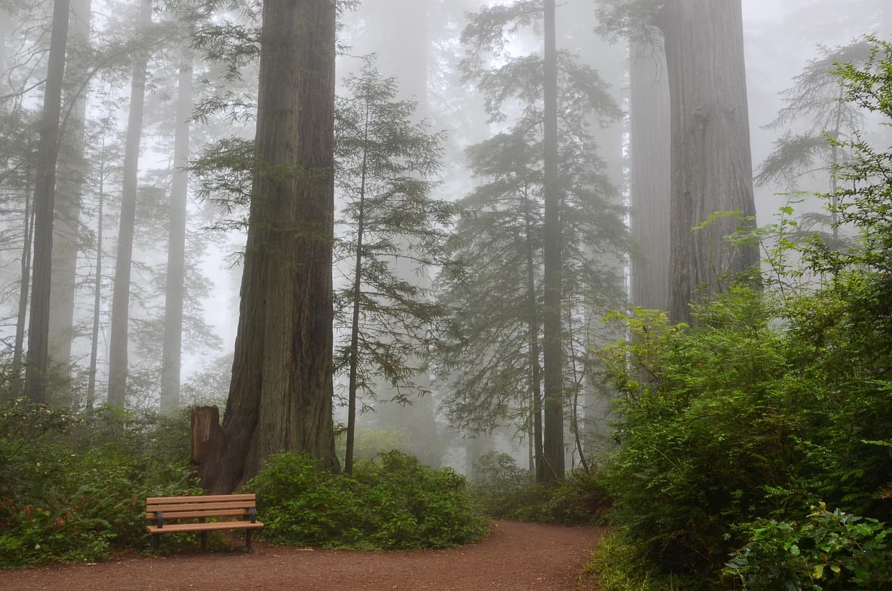
Redwood Creek Trail Loop (Muir Woods Extension)
Photo by USA-Reiseblogger on Pixabay
The main bridge over Redwood Creek gives the classic reflected-canopy shot โ€” best in the midday hush when light filters straight down.
Flat sections of the main loop are wheelchair accessible with benches roughly every 200 meters.
20 min drive โ€” A coastal descent along Panoramic Highway, the ocean appearing suddenly around a bend like a reward.
4:30 PM - 6:30 PM
Stinson Beach ยท evening ยท 120 min ยท Marin Headlands & Mount Tamalpais

End the day where the mountain's forests give way to open sky and crashing surf โ€” Stinson Beach at late afternoon has a softness to its light that suits slow walks and quiet conversation. The crowds thin after 4pm, leaving mostly locals and the occasional dog chasing gulls. Walk toward the southern bluffs as the sun angles low; the rocky outcrop near the lifeguard tower is a good spot to sit together and watch the tide shift.
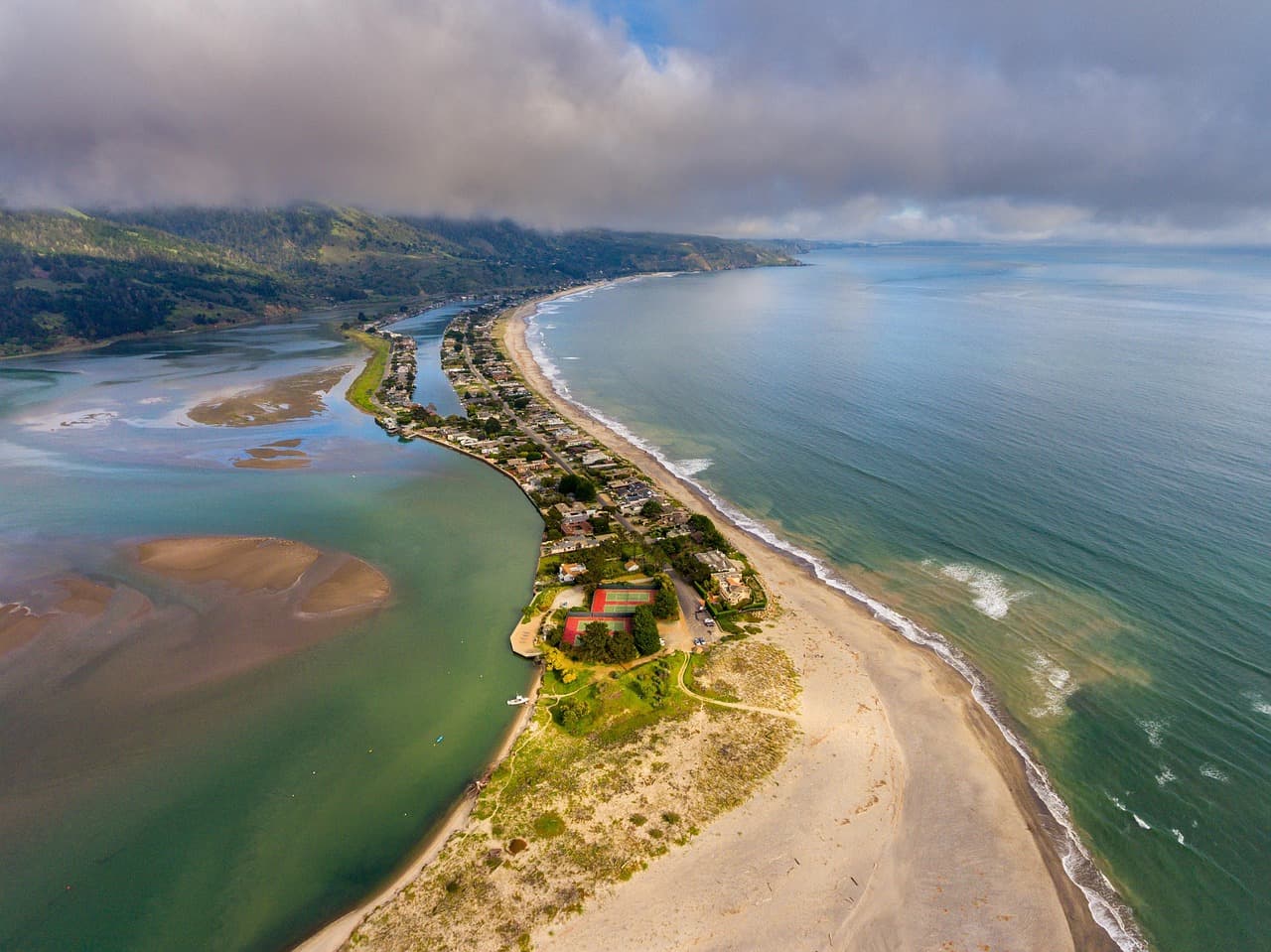
Stinson Beach
Photo by derwiki on Pixabay
Shoot from the southern end of the beach looking north toward the bluffs โ€” golden hour turns the cliffs amber.
Stinson Beach is flat and wheelchair accessible along most of its main stretch.
If it rains: If rain settles in, swap the Mount Tamalpais summit for a slower morning in Sausalito's waterfront galleries, then keep Muir Woods on schedule โ€” the redwoods are often more atmospheric, not less, in light rain and mist.

The day opens on Mount Tamalpais, reached before the fog fully lifts โ€” an early arrival rewards you with a nearly empty summit, cool wind, and a 360-degree view that makes the whole Bay Area feel small and quiet at once. A short walk from the parking area to the Pantoll overlook is unhurried, meant for lingering rather than checking off.

From ridgeline to redwood floor, the mood shifts entirely โ€” Muir Woods wraps you in cool, hushed air and ancient scale, best experienced slowly, hand in hand along the Main Trail. The adjoining Redwood Creek Trail Loop extends this calm with flatter terrain and creekside quiet, a gentle decompression before the day's final stretch.

The afternoon closes at Stinson Beach, where forest gives way to open Pacific horizon and the light softens into gold. Walk the shoreline as crowds thin, watch the tide pull back from the rocky outcrops, and let the roar of the surf be the evening's soundtrack before heading back to settle in for the night.

Coastal Wilderness

Day 2: Wild Edges of Point Reyes

A more active second day exploring Point Reyes' dramatic cliffs and elk-roamed ridgelines, covering roughly 3.5โ€“4 miles of trail walking with a moderate energy level throughout.

Wear
Wind-resistant layers, a waterproof outer shell, sturdy hiking shoes with ankle support, and a hat that won't blow away โ€” Point Reyes wind is relentless and often colder than it looks.
Budget
$120โ€“170 for two (park access, lunch, dinner, coffee stops)
75 min drive โ€” A long but scenic haul up Highway 1 and inland roads, with a worthwhile pullover at the Marin French Cheese Co. roadside stop if you want to stretch your legs midway.
8:00 AM - 10:00 AM
Point Reyes (Chimney Rock, Tomales Point) ยท morning ยท 120 min ยท Point Reyes National Seashore

Arrive early and Chimney Rock's overlook is yours alone โ€” golden grasslands dropping into sea cliffs, waves breaking white against the rocks below, and often a tule elk or two grazing in the distance. By late morning, weekend crowds thicken along the main pullouts, so this window is the one for uninterrupted awe. The wind here is constant and bracing, part of the appeal rather than a nuisance.

Point Reyes (Chimney Rock, Tomales Point)
Golden Gate Audubon Society.; Audubon Association of the Pacific.; Audubon Society of the Pacific. / wikimedia (Public domain)
The Chimney Rock overlook is best photographed mid-morning, when the light is soft but the fog has usually cleared enough to reveal the white-sand beach below.
Main overlook paths are uneven and unpaved; not suited to wheelchairs or those with mobility limitations.
15 min drive โ€” A short hop north along the peninsula road, past old ranch fences and grazing cattle.
10:30 AM - 1:00 PM
Tomales Point Trail ยท midday ยท 150 min ยท Point Reyes National Seashore

This is the day's centerpiece for couples who want a proper adventure together โ€” a ridge trail with the Pacific churning on one side and calm Tomales Bay on the other, tule elk herds often visible from a respectful distance. The full out-and-back is long, so consider walking just to the mile 1.5 overlook and back for a shorter, still-spectacular version. Wind is near-constant; it's part of what makes the views feel so wide open and cinematic.
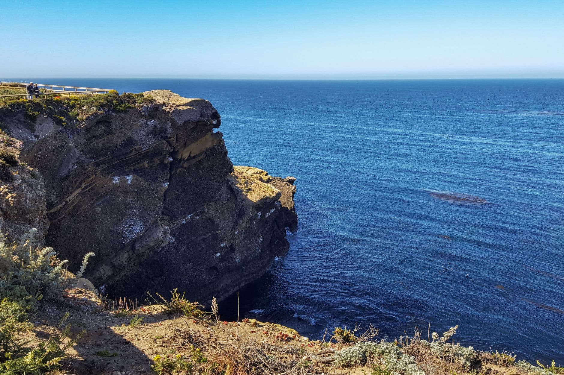
Tomales Point Trail
Photo by dh tang on Pexels
The mile 1.5 overlook captures both bay and ocean in a single frame โ€” best light is midday when the water's blue deepens against the golden grass.
Not wheelchair accessible; uneven terrain and significant walking distance make this a poor fit for limited mobility.
90 min drive โ€” A long transitional drive south, ideally timed to catch the coastline's changing light as afternoon turns to evening.
5:30 PM - 8:30 PM
Half Moon Bay ยท evening ยท 180 min ยท Half Moon Bay & Coastal Bluffs

Trade wild bluffs for a softer, small-town evening in Half Moon Bay, where fishing boats bob in Pillar Point Harbor and Main Street glows with early evening light. This is the splurge dinner of the trip โ€” settle into The Flying Fish Grill for fresh, simply prepared seafood, or if you're craving something more composed, ask about reservations at a table with harbor views. Afterward, a slow walk down Main Street rounds out the night without rushing toward a curfew.

Half Moon Bay
Elliot, G. F. Scott (George Francis Scott), 1862-1934 / wikimedia (Public domain)
Pillar Point Harbor at sunset silhouettes the fishing boats against the water โ€” arrive by 7pm for the best light.
Half Moon Bay's downtown and harbor overlook are flat and wheelchair accessible with frequent benches.
Dinner
The Flying Fish Grill $$
seafood ยท Near Half Moon Bay
Fresh, no-fuss seafood in a relaxed setting โ€” the day's catch done simply and well, a fitting close to a coastal day.
Main Street Grill $$
american ยท Near Half Moon Bay
A comfortable, unpretentious option for couples who want a hearty meal without ceremony.
Tortellini Originali $$
italian ยท Near Half Moon Bay
Cozy, candlelit Italian fare โ€” a good pick if seafood isn't the mood tonight.
Optional detour: Alamere Falls Trail โ€” After Point Reyes (Chimney Rock, Tomales Point) and before Tomales Point Trail
A dramatic waterfall spilling directly onto a wild beach โ€” one of the most photogenic sights in the entire region, especially with spring wildflowers along the approach. Skip if: At 4+ hours round trip and a genuinely strenuous descent, it will crowd out the rest of the day's plans and isn't recommended if you also want to walk Tomales Point.
Optional detour: Pescadero State Beach & Marsh Natural Preserve โ€” After Tomales Point Trail and before Half Moon Bay
Sandstone cliffs and a wildlife-rich marsh make a striking, quieter detour on the way south, especially good for golden-hour photography. Skip if: Adds real drive time to an already long day โ€” better saved for a trip where Half Moon Bay is the sole focus.
If it rains: If heavy rain moves in, skip Tomales Point Trail (it becomes genuinely slippery and hazardous) and instead spend the extra time at the Point Reyes Visitor Center near Chimney Rock, then head to Half Moon Bay early to explore its covered downtown galleries and shops before dinner.

The day begins at Point Reyes' Chimney Rock, arriving early enough to have the cliffside overlook to yourselves โ€” golden grasslands, crashing surf, and if you're lucky, distant elk grazing in the wind-scoured light. It's a landscape that rewards patience and quiet observation more than checklist-style sightseeing.

The pace shifts into something more physical at Tomales Point Trail, where a ridge walk between bay and ocean offers sweeping views and genuine adventure โ€” couples who want to feel the wildness of this coast firsthand will find it here, wind in their faces the whole way.

The evening softens considerably in Half Moon Bay, where harbor lights and Main Street's easy charm replace the day's wide-open drama. Dinner at The Flying Fish Grill or one of its Main Street neighbors closes the trip on a warm, unhurried note, with just enough time afterward for a slow harborside walk before the night winds down.

Want to tweak this trip?

Our AI planner can customize this itinerary to your exact dates, interests, and travel style.

Customize This Itinerary
Good to Know

Restaurant details (hours, menus, availability) change frequently. Check current hours before visiting, especially in seasonal destinations.

Dietary compatibility tags are general guidance. If you have severe allergies, confirm directly with the restaurant.

Travel tips are general guidance, not professional safety advice. Check government advisories for latest information.

All prices are approximate and may vary seasonally.
We use cookies to improve your experience and analyze site usage. Essential cookies are always active. You can customize your preferences or accept all cookies. Cookie Policy