3 DaysTeen Families6 Stops

San Francisco Bay Area (day trips), California

3-Day Itinerary for Teen Families

Redwoods, Ridgelines & Rugged Coast: 3 Days Beyond the Golden Gate

Redwoods, Ridgelines & Rugged Coast: 3 Days Beyond the Golden Gate

The fog doesn't just roll in here—it arrives like a living thing, swallowing ridgelines and softening redwood cathedrals into something almost sacred. This is a trip built for families with teens who want real adventure: cliff-edge trails, ancient trees taller than buildings, and enough open road between stops for everyone to just breathe.

At a Glance

Climate & Weather
Summer (July–August) brings mild 60–63°F days with persistent coastal fog, especially mornings; pack layers, a waterproof windbreaker, and closed-toe hiking shoes—flip-flops won't cut it on these trails. Afternoons inland can turn surprisingly warm, so a light long-sleeve layer that packs down is ideal.
Getting Around
A rental car is essential—all three days require driving between clusters, with no meaningful transit link. Roads are scenic but winding (CA-1, CA-92), so budget extra time and consider swapping drivers for the curvier stretches.
Budget
Budget roughly $80–130/day per family of four for food and activities, factoring in Muir Woods reservation fees, casual sit-down meals, and coffee/snack stops.
Safety
Coastal bluffs and cliff-edge trails have sudden drop-offs—remind teens to stay on marked paths, especially at Point Reyes and Pigeon Point. Fog can reduce visibility fast on Mount Tam, so keep the group together on ridge sections.
Connectivity
Cell coverage is spotty to nonexistent in Muir Woods, on Mount Tam's forested trails, and along much of the Point Reyes peninsula—download offline maps before you leave San Francisco.
Local Tips
Muir Woods requires a timed-entry parking or shuttle reservation booked well in advance—don't skip this step. Arrive at trailheads by 7:30–8am on weekends to beat both crowds and the midday heat; Bay Area summer fog usually burns off by late morning, rewarding early risers with clear skies by noon.

Highlights

  • Sunrise-quiet redwood groves before the crowds arrive at Muir Woods
  • 360-degree views from Mount Tamalpais stretching to the Sierra Nevada
  • Tule elk roaming windswept bluffs at Point Reyes
  • Sandcastle-and-tidepool afternoons at Stinson Beach
  • Fresh-caught seafood at Pillar Point Harbor in Half Moon Bay
  • Golden hour at Pigeon Point Lighthouse, California's tallest
  • Teen-friendly trail autonomy on gentle, well-marked loops

Day-by-Day Plan

Arrival & Gentle Immersion

Day 1: Redwood Hush & Ridge Light

An easy first day easing into Bay Area rhythm with a quiet redwood grove walk followed by a scenic, low-effort ridge drive—about 2.5 miles of walking total, moderate energy.

Wear
Layers—light jacket for cool, misty morning air under the redwood canopy, breathable shirt underneath for warmer afternoon sun on the ridge; sturdy sneakers or light hikers.
Budget
$70–100 for the family (parking/reservation fees, casual lunch, snacks)
8:00 AM - 9:30 AM
Muir Woods (early reservation) · morning · 90 min · Muir Woods & Mill Valley

Book the earliest reservation slot you can get—by 8am the fog is still threading through the canopy and the grove feels like it belongs to your family alone. The 2,000-year-old redwoods rise in cathedral silence, broken only by Redwood Creek's murmur and the soft crunch of needles underfoot. Teens who roll their eyes at 'another nature walk' tend to go quiet here—the scale is genuinely humbling.

Muir Woods (early reservation)
Ontario. Royal Commission on Forest Reservation and National Park / wikimedia (Public domain)
Shoot the twin redwoods near the entrance in the soft, diffused morning light before 9am—direct sun later flattens the scene.
Main boardwalk sections are wheelchair-friendly, but side trails have roots and uneven ground.
5 min walkA short stroll from the main Muir Woods trailhead, the transition barely noticeable as one grove blends into the next.
9:40 AM - 10:40 AM
Redwood Creek Trail Loop (Muir Woods Extension) · midday · 60 min · Muir Woods & Mill Valley

An easy extension loop that lets teens range slightly ahead on their own while parents linger at the creek—flat, well-benched, and forgiving. Cathedral Grove here is the most photogenic concentration of ancient trees in the whole park, with light filtering down in shafts by mid-morning.
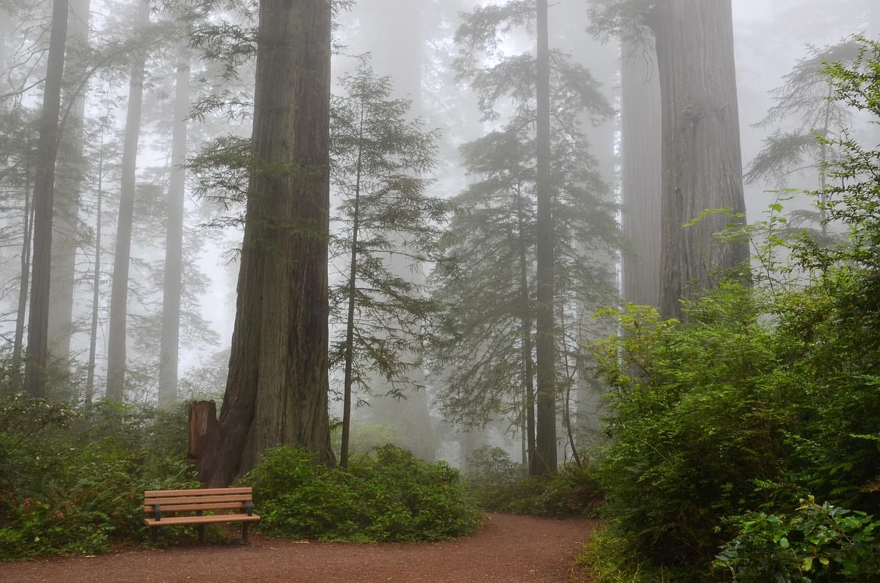
Redwood Creek Trail Loop (Muir Woods Extension)
Photo by USA-Reiseblogger on Pixabay
The main bridge over Redwood Creek offers a classic reflected-tree shot—best between 9:30 and 11am before crowds fill the frame.
Flat sections of the main loop are wheelchair accessible with benches every 200 meters.
If it rains: Trails remain open and atmospheric in light rain—waterproof layers make the muted, misty grove even more magical. In a downpour, shift to Sausalito's covered waterfront galleries and shops instead.

The day begins in hush and shadow. Under Muir Woods' redwood canopy, the light is soft and green-tinged, the air cool and thick with the scent of damp bark. Arriving right at opening means the boardwalks are nearly empty—just birdsong, creek murmur, and the occasional gasp from a teen craning their neck up at trees that predate most civilizations.

After the extension loop, the pace stays easy—no long drives, no rush. This is a day for settling into Bay Area time: cool mornings, fog lifting by midday, everyone adjusting to the rhythm of a place where nature sets the schedule, not the itinerary.

With no dining data available near these forested stops, plan to return toward your base (San Francisco, Sausalito, or wherever you're staying) for dinner—use the drive back to debrief the day's discoveries and let everyone recharge before an early start tomorrow.

Ridge to Shoreline

Day 2: Peak, Wind, and Wave

A moderately active day covering Mount Tamalpais' ridgeline views and Stinson Beach's sandy shoreline—roughly 3-4 miles of walking, moderate-to-high energy.

Wear
Windbreaker for the exposed summit ridge (it's colder and windier than it looks from the valley), swimsuit and towel for optional beach wading, sunscreen for when the fog burns off, sturdy trail shoes that can also handle sand.
Budget
$60–90 for the family (parking, casual beach-town lunch, snacks)
7:30 AM - 10:00 AM
Mount Tamalpais · morning · 150 min · Marin Headlands & Mount Tamalpais

Arrive by 7:30am and the East Peak parking area is nearly empty, the whole Bay laid out below in that rare pre-crowd stillness. Short loop trails near Pantoll Ranger Station keep the family together without demanding a full summit push—wind hums through the Douglas firs, and on a clear day you can trace the curve of the coast all the way to the city skyline. By 9am, cars start filling the lot; you'll already be ahead of it.

Mount Tamalpais
Banks, Charles Eugene, 1852-1932 Read, Opie Percival, 1852-1939 / wikimedia (Public domain)
East Peak summit at sunrise offers the clearest light and thinnest crowds—arrive before 8am for a nearly untouched panorama.
Paved overlooks near the main parking area are accessible; most trails involve uneven terrain and elevation change.
25 min driveA winding descent on Panoramic Highway, switchbacks opening suddenly to ocean views that make everyone go quiet in the car.
11:00 AM - 2:00 PM
Stinson Beach · afternoon · 180 min · Marin Headlands & Mount Tamalpais

The descent from mountain wind to beach warmth feels like flipping a switch—Stinson's wide sandy curve invites teens to wade, throw a frisbee, or just sprawl out while parents finally exhale. Pacific swells here are genuinely big and loud, kelp and salt thick in the air, with a rocky tide-pool outcrop north of the lifeguard tower worth exploring at low tide.
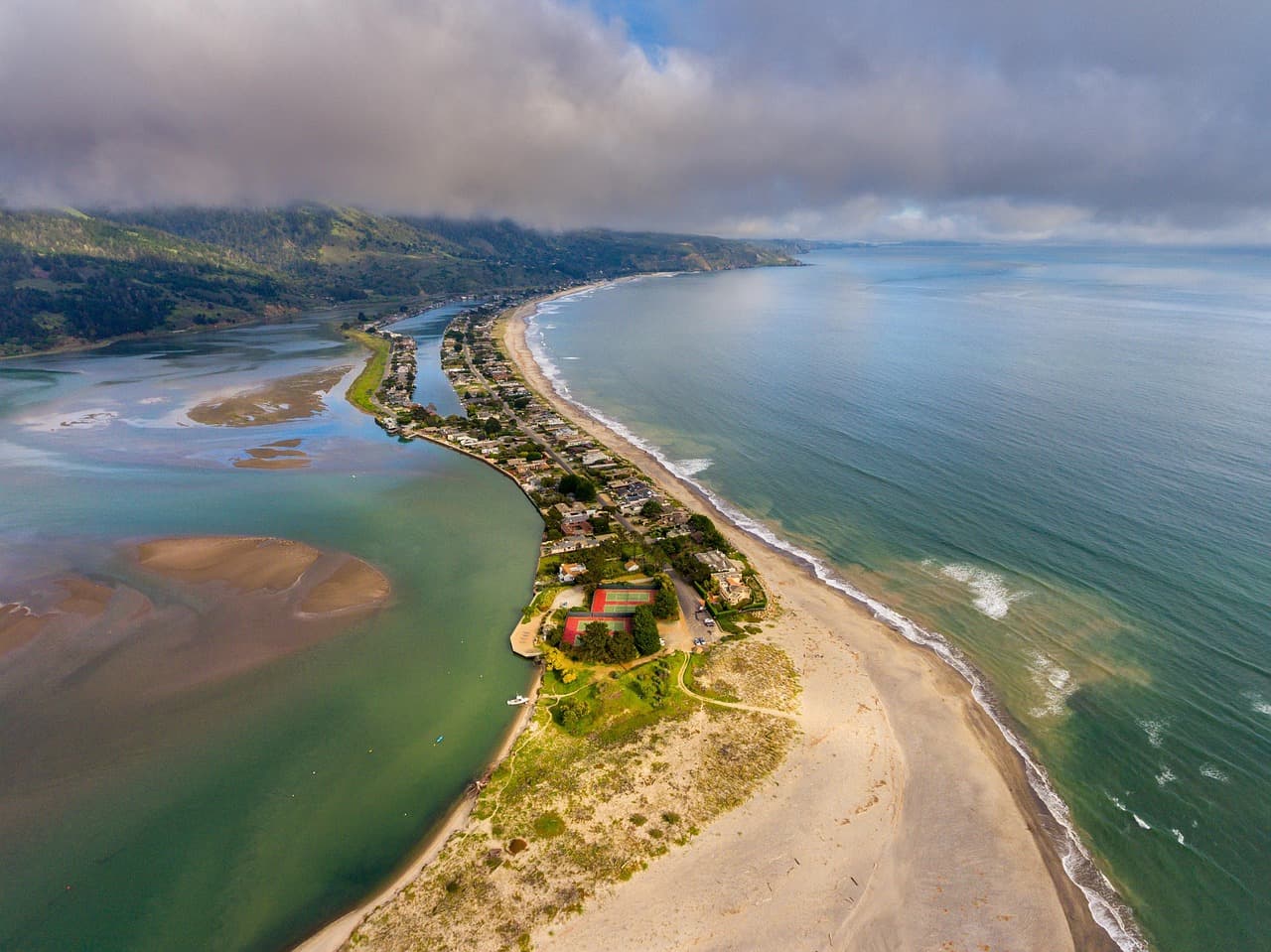
Stinson Beach
Photo by derwiki on Pixabay
Shoot from the southern end of the beach looking north toward the bluffs—best light in late afternoon, but arrive earlier to beat the midday crowd surge.
Main beach area is flat and wheelchair accessible, though sand itself is loose underfoot.
Optional detour: Redwood Creek Trail Loop (Muir Woods Extension)Between Mount Tamalpais and Stinson Beach
If the family wants one more shaded, easy walk before beach time, this gentle loop is a low-effort add-on given its proximity via Panoramic Highway. Skip if: Skip if you did this loop on Day 1 or if beach time is the priority—doubling up on forest walks in one trip can feel repetitive.
If it rains: If fog or rain rolls in heavy, swap the beach block for a return visit to Muir Woods or a stroll along Sausalito's covered waterfront—both remain atmospheric even when wet.

Cold mountain air bites at first, but it wakes everyone up fast. The ridge trails near Pantoll Ranger Station wind through fir and manzanita, views opening unexpectedly at switchbacks—first a sliver of bay, then the whole horizon. This is the kind of view that makes teens put their phones away, if only for the photo.

The mood shifts entirely by early afternoon—wind gives way to sun, pine scent to salt air, as the family trades ridge trails for warm sand. Stinson's energy is looser, more social; this is where teens get a bit of autonomy to explore the tide pools or just claim a patch of beach while parents relax nearby.

No verified dining options exist near Stinson Beach in our data, so plan your evening meal back toward your home base—use the drive to talk through favorite moments from the peak-to-beach contrast, and get to bed early ahead of tomorrow's longer Point Reyes day.

Coastal Wilderness

Day 3: Wild Edges of the Peninsula

The most adventurous day of the trip, covering dramatic cliffs and wildlife-rich trails at Point Reyes—approximately 4 miles of walking, high energy with built-in rest stops.

Wear
Layered windproof jacket (Point Reyes is famously windy and can be 10 degrees cooler than inland), closed-toe hiking shoes with good grip, sun hat and sunscreen for exposed grassland sections.
Budget
$50–80 for the family (park fees minimal, casual lunch, snacks)
8:00 AM - 10:00 AM
Point Reyes (Chimney Rock, Tomales Point) · morning · 120 min · Point Reyes National Seashore

Get here early—by 8am the parking lot at Chimney Rock is nearly empty and the light is soft and gold across the grasslands. Cliffs plunge dramatically into a churning Pacific, tule elk sometimes visible grazing in the distance, and the wind is constant, briny, and bracing. This is prime teen-autonomy territory: short, well-marked trails let them range a bit ahead while staying in sight.

Point Reyes (Chimney Rock, Tomales Point)
Golden Gate Audubon Society.; Audubon Association of the Pacific.; Audubon Society of the Pacific. / wikimedia (Public domain)
Chimney Rock overlook is best photographed mid-morning when fog has cleared but the light is still soft—look for the white-sand beach and sea stacks below.
Trails here involve uneven terrain and no paved sections; not wheelchair accessible.
20 min driveA short hop along Pierce Point Road, cattle guards rattling underneath the car and elk sometimes visible right from the roadside.
10:15 AM - 12:15 PM
Tomales Point Trail · midday · 120 min · Point Reyes National Seashore

Rather than the full 4-hour trek, tackle the first 1.5–2 miles out and back—enough to reach the dramatic overlook where bay and ocean views collide, without exhausting younger teens. Tule elk herds are often visible along this stretch, and the wind never really stops, carrying the sharp scent of coastal sage across open grassland.
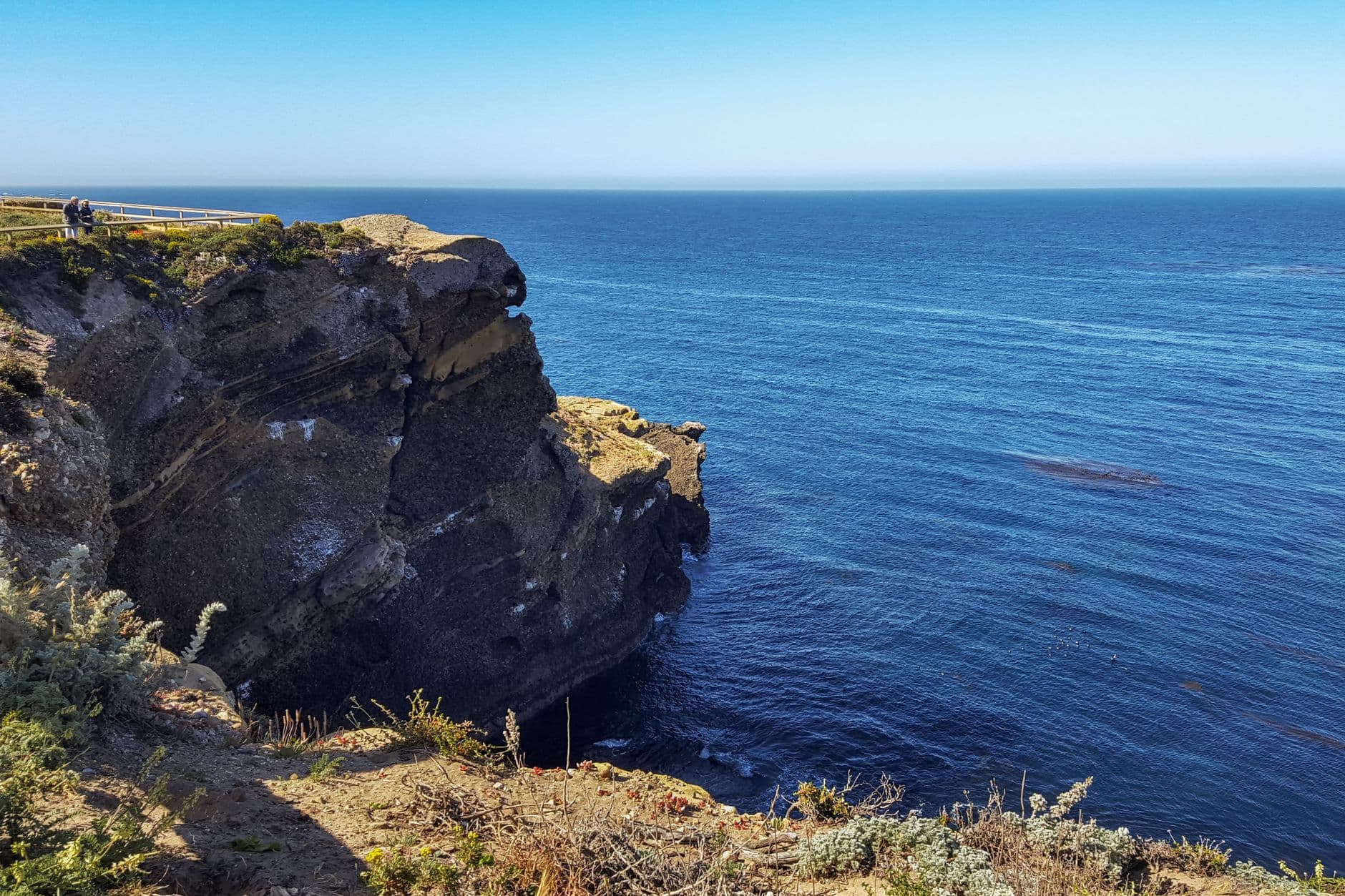
Tomales Point Trail
Photo by dh tang on Pexels
The overlook at roughly mile 1.5 captures both Tomales Bay and the open Pacific in one frame—best light late morning before haze sets in.
Uneven, unpaved trail throughout; not recommended for those needing accessible terrain.
Optional detour: Alamere Falls TrailAfter Point Reyes (Chimney Rock) and before Tomales Point Trail
For families with older, more adventurous teens, this dramatic waterfall-onto-beach hike is a bucket-list add if you have a full extra day to dedicate to it. Skip if: At 4-6 hours round trip, it's too long to combine with Tomales Point in a single day—skip unless you're willing to make it the day's sole anchor.
If it rains: Point Reyes trails become dangerously muddy and slippery in rain with visibility dropping fast—if weather turns, stick to short loops near the visitor center only, or reschedule this day for clearer skies given the exposed, cliff-edge terrain.

The peninsula announces itself with wind before anything else—a steady, briny push that never really stops. Chimney Rock's cliffs are stark and beautiful, grasslands rippling gold in the early light, and there's a real sense of being at the edge of the continent that even skeptical teens tend to feel.

Tomales Point extends that wildness further north—open, elk-dotted grassland stretching along a narrow spine between bay and ocean. Shortening the hike to the first overlook keeps energy levels manageable while still delivering the trail's signature payoff view.

With no verified restaurant data near Point Reyes stops, plan your dinner back in San Francisco or wherever you're staying—the drive back offers a natural wind-down, windows cracked to the last of the coastal air, everyone tired in that good, sun-and-wind-worn way that marks a trip well spent.

Want to tweak this trip?

Our AI planner can customize this itinerary to your exact dates, interests, and travel style.

Customize This Itinerary
Good to Know

Restaurant details (hours, menus, availability) change frequently. Check current hours before visiting, especially in seasonal destinations.

Dietary compatibility tags are general guidance. If you have severe allergies, confirm directly with the restaurant.

Travel tips are general guidance, not professional safety advice. Check government advisories for latest information.

All prices are approximate and may vary seasonally.
We use cookies to improve your experience and analyze site usage. Essential cookies are always active. You can customize your preferences or accept all cookies. Cookie Policy