3 DaysSolo Traveler6 Stops

Blue Ridge (North GA), Georgia

3-Day Itinerary for Solo Traveler

Waterfalls, Summits & Steel Rails: 3 Days Alone in Blue Ridge

Waterfalls, Summits & Steel Rails: 3 Days Alone in Blue Ridge

The mist off Amicalola Falls beads on your skin before 8am, long before the parking lot fills. Blue Ridge in summer rewards the solo traveler who moves early and lingers late — cool ridgelines, roaring water, and small-town porches where nobody minds if you eat dinner alone at the bar.

At a Glance

Climate & Weather
Summer in Blue Ridge stays mild for the South, rarely topping 75°F, but humidity and sun at elevation make mornings the smart time to hike. Pack breathable layers, a light rain shell for sudden mountain showers, sunscreen, and sturdy shoes with grip for wet rock near waterfalls.
Getting Around
A rental car is essential — this is mountain terrain with no meaningful public transit. Distances between clusters run 30-60 minutes, so fuel up and start early to avoid midday summer crowds at trailheads.
Budget
Expect roughly $60-100/day covering trail-adjacent meals, a rail ticket, park parking fees, and casual dinners — solo dining and modest activity costs keep this affordable.
Safety
Solo hikers should tell someone their trail plan, carry more water than feels necessary, and watch for sudden weather shifts and flash-flood risk in gorges after rain. Black bears are present in remote areas — store snacks sealed and make noise on quieter trails. Cell service drops in gorges and on summit roads, so download offline maps in advance.
Connectivity
Cell coverage is reliable in downtown Blue Ridge but spotty to nonexistent in gorges, at higher elevations, and along river roads. Most lodging offers WiFi; download maps and trail info before heading out each morning.
Local Tips
Arrive at trailheads by 7:30-8am in summer to beat both heat and weekend crowds; shops in town don't open until 10am, so mornings are made for nature, afternoons for browsing; ask bartenders at local pubs about current trail conditions — they usually know before the rangers post updates.

Highlights

  • Sunrise mist at Georgia's tallest waterfall
  • 360-degree views atop Brasstown Bald before the haze rolls in
  • A vintage train winding along the Toccoa River
  • Standing at the rim of a thousand-foot gorge
  • Solo-friendly bar seating in downtown Blue Ridge
  • Golden hour at a heritage depot platform

Day-by-Day Plan

Arrival & Waterfall

Day 1: Mist, Moss, and the Long Walk Down to Water

A gentle orientation day mixing a moderate waterfall hike with an easy afternoon exploring downtown Blue Ridge on foot, roughly 3-4 miles total.

Wear
Moisture-wicking layers, trail shoes with good tread for wet rock, a light rain jacket, and a hat for sun once you're out of the falls' shade.
Budget
$50-70 (parking fee, lunch, dinner, casual shopping)
7:30 AM - 9:30 AM
Amicalola Falls · morning · 120 min · Downtown Blue Ridge & Amicalola Falls

Arrive by 7:30am and the falls are yours — just the thunder of 729 feet of falling water, cool mist settling on your arms, and the earthy hemlock smell of a forest still damp from night. By 9am the switchback trail fills with weekend crowds; early light through the rhododendrons is also your best photography window. Solo travelers often strike up conversation with fellow early hikers at the base overlook — a natural icebreaker before the trail narrows.

Amicalola Falls
Connor Scott McManus / pexels (Pexels License)
Shoot from the base overlook platform for the full cascade, then catch the upper viewpoint for a dramatic downward angle — both work best before 9am when mist and light align.
The base viewpoint is reachable via a short paved path, but the full falls trail involves steep, uneven terrain unsuitable for wheelchairs.
10 min walkA short stroll back up from the base overlook, calves burning slightly, birdsong replacing the roar of water
9:30 AM - 10:30 AM
Amicalola Falls · midday · 60 min · Downtown Blue Ridge & Amicalola Falls

Spend a slower hour near the visitor center or lodge area, refilling water and letting your legs recover before the drive into town — a good buffer if the trail ran long or the heat built faster than expected.

Amicalola Falls
Connor Scott McManus / pexels (Pexels License)
If skies are clear, the lodge grounds offer a quieter, wide-angle shot of the ridge line without crowds in frame.
Flat, paved paths near the lodge and visitor center are wheelchair accessible.
Lunch
Maple Restaurant $$
Local · Near Amicalola Falls
A relaxed spot near the falls serving hearty Southern plates — solo diners can grab counter seating and refuel before the drive into town.
Optional detour: Amicalola Falls Trail switchbacksAfter the base overlook and before returning to the lodge
The switchbacks offer intimate, close-up cascade views framed by rhododendrons, quieter than the main overlook. Skip if: Skip if your knees are already tired or you're pressed for time before lunch — the base view alone captures the falls' scale.
If it rains: If it rains, the falls become even more dramatic to view but trails turn slippery — stay dry at the lodge or visitor center and wait out the worst before returning to the overlook.

You'll want to be standing at the base of Amicalola Falls before the town has even opened its shutters — 7:30am light slanting through hemlock and rhododendron, the roar of Georgia's tallest waterfall filling the cool morning air. The trail switchbacks upward, mist clinging to your skin, and for an hour or so it feels like the whole mountain belongs to you before the first tour buses arrive.

By midday, the pace eases — a slow wander near the lodge grounds, water bottle refilled, muscles loosening after the climb. This is the moment to let the morning's exertion settle before pointing the car toward downtown Blue Ridge, where narrow streets and porch-front shops wait in the golden early afternoon light.

Dinner tonight is unhurried — a plate of Southern comfort food and a seat where solo diners are entirely at home. Let the evening wind down slowly; tomorrow's summit and rail day asks for rested legs and an early start.

Summit & Steam

Day 2: Rooftop of Georgia and Rails Through the Haze

A full day split between a high-elevation summit hike and a scenic heritage train ride, roughly 2-3 miles of walking with moderate elevation exertion.

Wear
Layer up for cooler summit air even in summer — a light fleece or windbreaker, plus comfortable shoes for the train's platform stops and short walks.
Budget
$70-110 (train ticket, summit parking, lunch, dinner)
75 min driveA winding mountain drive northeast from downtown Blue Ridge, radio off, windows cracked to the scent of pine climbing toward the ridge
8:00 AM - 10:00 AM
Brasstown Bald · morning · 120 min · Scenic Ridge Loop

Arrive by 8am and the thin, cool air at Georgia's highest point is nearly empty of other visitors — wind rushing through stunted summit trees, views stretching across three states in a fading blue haze. The observation tower's creak underfoot and the 360-degree panorama make this one of the state's best solo photography stops; by 10am, tour groups start arriving in numbers.

Brasstown Bald
ChattOconeeNF / openverse (by)
Shoot from the observation tower's west-facing parapet in morning light, when haze hasn't yet thickened over the Tennessee and Carolina ridgelines.
The summit area and tower are wheelchair accessible via a paved path and shuttle option; hiking spurs beyond the tower are not.
75 min driveBacktrack southwest toward the depot, the ridge road unspooling in reverse, cell signal slowly returning as elevation drops
12:30 PM - 2:30 PM
Blue Ridge Railway · afternoon · 120 min · Scenic Ridge Loop

The train pulls out with a nostalgic steam whistle and the smell of coal smoke drifting past rhododendron-draped embankments. Request a window seat on the right side northbound for the Toccoa River trestle crossing — a suspended, swaying moment above the water that's worth the whole ride. The open-air observation car is a natural spot to chat with fellow solo travelers as the mountains slide by.

Blue Ridge Railway
Ken Lund / openverse (by-sa)
The station platform at golden hour, locomotive profile against the heritage depot, is the classic shot — but the trestle crossing at midday offers the most dramatic mountain backdrop.
The train and platform are wheelchair accessible with assistance for boarding.
Lunch
Chester Brunnenmeyer's Bar & Pub $$
Pub fare · Near Blue Ridge Railway
A lively pub near the depot with bar seating that suits solo diners — good for a hearty meal before or after the train ride.
Rum Cake Lady Cuban $
Cuban · Near Blue Ridge Railway
A quick, flavorful change of pace from Southern comfort food, casual counter service ideal for solo travelers on a schedule.
Dinner
The General Ledger $$$
Local · Near Blue Ridge Railway
A polished but unpretentious spot with a bar you can settle into alone, contemporary Southern plates with real depth.
Whiskey & Water $$
Local · Near Blue Ridge Railway
A cozy tavern atmosphere good for striking up conversation with locals over a whiskey flight and mountain trout.
Optional detour: Brasstown Bald observation tower exhibitsAfter summit views and before heading back down the mountain
A quick 45-minute detour into the tower's exhibits adds context on the region's ecology and history for a low physical cost. Skip if: Skip if you're racing the clock to make the train departure — the summit views alone justify the stop.
If it rains: If it rains, the observation tower stays partially accessible though views vanish into cloud — consider Sosebee Cove or lower-elevation Vogel State Park as a scenic alternative, and check with the railway directly, as trains typically still run in light rain with covered observation cars.

The drive up to Brasstown Bald winds through cooling air and thickening pine, and by 8am you're standing above the clouds — literally, some mornings — with three states rolling out in blue-grey layers below. The tower creaks gently in the wind; for a solo traveler, this kind of vast, quiet view feels earned rather than performed.

Back down the mountain, the pace shifts entirely — steam whistle, clacking rails, and the unhurried sway of a vintage train car replacing the wind-scoured summit. The trestle crossing over the Toccoa River is a small thrill, water glinting far below the tracks, mountain laurel blurring past the window.

Dinner tonight calls for a seat at the bar — whiskey, trout, and easy conversation with whoever's perched nearby. It's the kind of low-key mountain evening that closes early, restaurants quieting by 9pm, leaving plenty of time to rest before tomorrow's gorge trek.

Gorge & Departure

Day 3: Standing at the Edge of the Gorge

A high-energy final day at Tallulah Gorge, mixing rim overlooks with optional gorge-floor trails, roughly 3-5 miles depending on trail choice.

Wear
Sturdy hiking shoes with grip for wet rock, moisture-wicking clothing, a hat and sunscreen for exposed rim sections, and a light layer for cooler morning air.
Budget
$40-60 (parking/permit fee, lunch, snacks for the road)
90 min driveAn early drive east from Blue Ridge through waking farmland and low fog, coffee in hand, radio low
7:30 AM - 10:00 AM
Tallulah Gorge · morning · 150 min · Tallulah Gorge

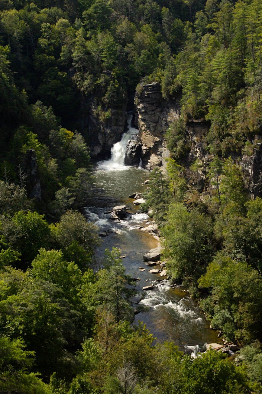
Arrive by 7:30am and Tallulah Point overlook is nearly silent save for the distant roar of water echoing off thousand-foot cliff walls — rust-red stone rising vertically, cool spray drifting up from below. This is the most dramatic straight-down vista in the park, and for a solo hiker it's a genuinely heart-quickening moment before crowds arrive by mid-morning. Tell someone your trail plan before descending, and carry more water than feels necessary — this is a high-energy stop.
Tallulah Gorge
John Zook / pexels (Pexels License)
Tallulah Point overlook in early morning light gives the cleanest straight-down shot before haze and crowds build; Hurricane Falls viewpoint later in the morning captures full cascade drama.
Rim overlooks are relatively flat and accessible; the gorge floor trail involves steep, uneven terrain and is not wheelchair accessible.
15 min walkA short walk along the rim path connecting overlooks, gorge sounds growing louder with each step
10:00 AM - 11:30 AM
Tallulah Gorge · midday · 90 min · Tallulah Gorge

If legs and permit allow, the descent toward Hurricane Falls and the Sliding Rock area offers a river-level perspective entirely different from the rim — water thundering past at eye level, the gorge walls closing in overhead. This is optional and strenuous; solo hikers should assess conditions and energy honestly before committing, since the climb back out is demanding in summer heat.

Tallulah Gorge
John Zook / pexels (Pexels License)
Sliding Rock area offers an intimate river-level shot rarely captured from the rim above.
Not accessible for wheelchairs or those with mobility limitations; steep stairs and uneven rock are involved.
Lunch
Tallulah 1882 $$
Café · Near Tallulah Gorge
A relaxed café near the gorge rim, good for refueling after a strenuous morning with casual counter or table seating suited to solo travelers.
Optional detour: Hurricane Falls viewpointAfter Tallulah Point overlook and before the gorge floor descent
A close-up view of the falls in full cascade adds visual variety to the straight-down rim perspective. Skip if: Skip if time is tight before the drive home or if the gorge descent already covers this ground.
If it rains: If it rains, stick to the rim overlooks — they remain accessible in light rain and the waterfalls are actually more dramatic after recent rainfall — but avoid any gorge descent due to slippery rock and flash-flood risk.

The gorge announces itself before you see it — a low roar rising from the trees as you approach the rim. Standing at Tallulah Point in the cool 7:30am air, watching mist drift a thousand feet below, is the kind of moment that reorders your sense of scale entirely, and having it mostly to yourself makes it more so.

For those with energy left, the gorge floor trail offers a second, humbler encounter with the same water — up close, thunderous, cooling the skin with spray. It's optional and demanding, so the honest choice is whichever leaves you with a genuine smile rather than gritted teeth on the drive home.

With the gorge behind you and the drive home ahead, there's time for one last unhurried meal near the rim before the road pulls you back toward Atlanta or wherever comes next — three days of water, summit air, and steel rails settling quietly into memory.

Want to tweak this trip?

Our AI planner can customize this itinerary to your exact dates, interests, and travel style.

Customize This Itinerary
Good to Know

Restaurant details (hours, menus, availability) change frequently. Check current hours before visiting, especially in seasonal destinations.

Dietary compatibility tags are general guidance. If you have severe allergies, confirm directly with the restaurant.

Travel tips are general guidance, not professional safety advice. Check government advisories for latest information.

All prices are approximate and may vary seasonally.

We use cookies to improve your experience and analyze site usage. Essential cookies are always active. You can customize your preferences or accept all cookies. Cookie Policy