4 DaysSolo Traveler8 Stops

Red River Gorge (Slade area), Kentucky

4-Day Itinerary for Solo Traveler

“Sandstone Solitude: 4 Days Alone in Red River Gorge”

Sandstone Solitude: 4 Days Alone in Red River Gorge

The gorge wakes up slow, mist pooling in the hollows while sandstone cliffs blush amber at first light. Out here, solitude isn't hard to find—just get up before the day-trippers do, and let 100 million years of stone do the talking.

At a Glance

Climate & Weather
Summer means warm, humid days (75–90°F) with afternoon thunderstorms rolling in fast—start hikes by 7-8am to beat both heat and storms. Pack moisture-wicking layers, a light rain shell, sun protection, and at least 2 liters of water per hike.
Getting Around
A car is essential—there's no public transit in the Slade area. Trailheads are connected by winding forest roads (KY-15, KY-77, Tunnel Ridge Road); expect 10-30 minute drives between clusters.
Budget
Budget roughly $40-70/day for a solo traveler—modest trailside or diner meals, a few dollars for parking/day-use fees, and minimal gear rental if needed.
Safety
Solo hikers should tell someone their route and expected return time, carry a paper map or offline GPS since cell service is spotty on trails, and avoid exposed ridgelines if thunderstorms are forecast. Watch footing on wet sandstone, make noise to avoid startling wildlife, and turn back if flash flood warnings are issued.
Connectivity
Cell service is unreliable to nonexistent on most trails and even patchy in Slade village; download offline maps before heading out and expect WiFi mainly at lodging.
Local Tips
Start every hike by 7:30am in summer—both for the light and to dodge the worst heat and crowds; weekday mornings mean you might have entire overlooks to yourself. Pack more water than you think you need, and check the radar before committing to ridge hikes since storms build fast in the afternoon.

Highlights

  • Standing alone beneath Sky Bridge's 78-foot span at sunrise
  • Ridge-walking Auxier's spine with nobody else in sight
  • Golden hour on Chimney Top Rock's weathered summit
  • Cool gorge air rising through Natural Bridge's arch
  • Trading trail stories with fellow hikers at a communal table
  • Beating the summer heat with dawn starts on exposed rock

Day-by-Day Plan

Settling in, gentle orientation

Day 1: Arrival & First Light on the Arch

A low-key arrival day easing into the gorge's rhythm with a moderate, well-marked hike—about 3 miles round trip, moderate energy.

Wear
Breathable hiking layers, sturdy trail shoes with grip, a hat, and sunscreen—midday sun is strong even under tree cover.
Budget
$35-50 (parking fee, packed lunch, casual dinner)
8:00 AM - 10:00 AM
Natural Bridge SP · morning · 120 min · Natural Bridge & Sky Bridge Loop

After settling into Slade, ease into the gorge with this iconic sandstone arch—Kentucky's postcard shot come to life. Arrive by 8am and the trail is nearly silent, just birdsong and the distant echo of water moving through the gorge below. The arch itself glows pale gold as morning light angles through the opening, and the cool air still holds a whisper of overnight dampness off the rhododendron.

Natural Bridge SP
Alfred William Howitt / wikimedia (Public domain)
Shoot from the trail approach in early morning light, when the sandstone catches a warm glow before the sun gets high and flattens the color.
Trail involves uneven stone steps and is not wheelchair accessible; benches are sparse, so pace yourself on the climb.
20 min drive — A winding forest road hugging ridgelines, windows down, the gorge occasionally flashing into view between trees.
11:00 AM - 12:30 PM
Sky Bridge · midday · 90 min · Natural Bridge & Sky Bridge Loop

A short scenic drive brings you to a second, equally dramatic arch—this one a 78-foot span you can walk beneath and feel the scale of. The canyon breathes cool air even as the day warms, and the trail's quiet drama makes it an easy solo wander with plenty of space to sit and just take it in.

Sky Bridge
Stella Blu / openverse (by)
Position yourself under the arch looking up for the most dramatic perspective—best light is late morning when the sun is high enough to illuminate the underside.
Uneven, rocky trail; not suitable for wheelchairs or those needing flat paths.
If it rains: If storms roll in, the Natural Bridge SP viewpoint area has some covered structures near the lodge; postpone the Sky Bridge trail since wet sandstone gets dangerously slick.

Ease into the gorge slowly today—no need to rush. Natural Bridge SP rewards an early start with near-empty trails and soft light pouring through the arch, the kind of quiet that makes solo travel feel like a gift rather than a compromise.

After Sky Bridge, let the afternoon go loose. Head back toward Slade, settle into your lodging, and consider a short walk along the Red River if energy allows—today is about acclimating, not pushing pace.

Options up here are limited for dinner—consider checking with your lodging host for the nearest family-run spot in Slade or Stanton, or pack a simple meal to enjoy on a porch as the gorge cools into evening blue.

High-energy summit day

Day 2: Ridge-Walking Solitude

A full-day ridge hike covering roughly 5-6 miles with significant elevation change and high energy demands—the most physically demanding day of the trip.

Wear
Moisture-wicking shirt, hiking pants or shorts, trail runners or boots with solid grip, sun hat, and a light rain shell in case afternoon storms build.
Budget
$30-45 (trail snacks, packed lunch, dinner)
25 min drive — A quiet forest road drive with almost no other cars this early, gorge silhouettes emerging as the sun climbs.
7:00 AM - 7:45 AM
Chimney Top Rock · morning · 45 min · Auxier Ridge & Chimney Top

Start here while the morning is still cool and the light is low and dramatic. Arrive by 7am and you'll likely have this weathered sandstone cap entirely to yourself—360-degree views of rust-red cliffs catching first light, the Red River a distant murmur below. It's a short, punchy warm-up before the longer ridge walk ahead.

Chimney Top Rock
Bjørn Christian Tørrissen / openverse (by-sa)
Shoot east-facing cliff walls right at sunrise—the rust-red rock lights up before the haze of midday sets in.
Rock scramble sections near the summit; not accessible for those needing flat or stable terrain.
15 min walk — A connector trail linking the two summits, gently descending through oak-hickory forest before opening onto the ridge.
8:30 AM - 11:30 AM
Auxier Ridge · midday · 180 min · Auxier Ridge & Chimney Top

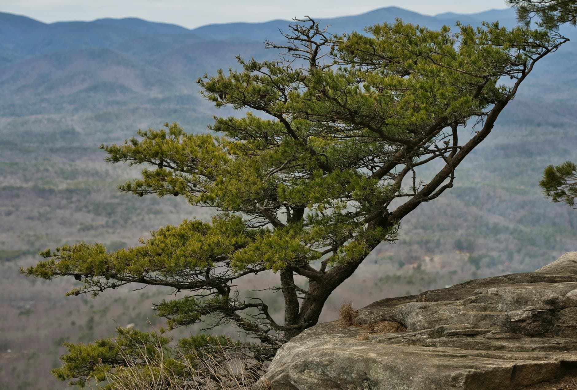
This is the heart of the day—a windswept ridgeline hike where the forest suddenly drops away to reveal layered ridges fading into blue haze. It's high-energy terrain, but the solitude here is real: weekday mornings especially, you might walk the whole spine without passing another soul. Bring extra water; there's no shade relief on the exposed sections, and by late morning the sandstone starts radiating heat.
Auxier Ridge
Thomas K / pexels (Pexels License)
The main ridge overlook facing south is best photographed mid-morning before haze builds—look for forest-framed vista points along the spine too.
Strenuous, uneven terrain with exposure; not recommended for those with mobility limitations or fear of heights.
Optional detour: Double Arch or Gray's Arch (shelter detour) — After Auxier Ridge and before heading back to Slade
A shaded rock shelter alternative if the day turns hot or storms threaten, offering a cooler, tree-covered pocket to rest. Skip if: Skip if you're already tired from the ridge hike or daylight is running short—it adds meaningful distance to an already long day.
If it rains: Wet sandstone on Auxier Ridge is genuinely dangerous—if thunderstorms are forecast, reroute to the sheltered areas near Double Arch or Gray's Arch, or postpone the ridge hike to tomorrow and swap in a lower-elevation walk.

Set an early alarm—this is the day the gorge's raw wilderness reveals itself. Chimney Top Rock at dawn is a quiet warm-up, cool air and long shadows setting the mood before the real climb begins.

By midday, Auxier Ridge's exposed spine will have you fully immersed—wide-open vistas, sun-warmed sandstone, and the kind of solitude that's hard to find elsewhere in the eastern US. Watch the sky for building clouds and start descending if thunder rumbles in the distance.

After a demanding day, dinner options near the trailheads are sparse—plan to eat back in Slade or Stanton where small diners cater to hikers winding down, or rely on food you've packed if timing runs late. Either way, an early night is earned.

Recovery & lighter exploration

Day 3: Slow Gorge Wandering

A lighter day of roughly 2-3 miles total, revisiting favorite spots at different light and pace after yesterday's exertion.

Wear
Comfortable hiking layers, breathable fabrics, and a swimsuit if you plan to cool off near the river; bring a light jacket for evening.
Budget
$25-40 (casual meals, minor gear or snack purchases)
7:30 AM - 9:00 AM
Natural Bridge SP · morning · 90 min · Natural Bridge & Sky Bridge Loop

Return here for a second look, this time with legs still loose from yesterday's climb and an appreciation for how different the light feels. Early light rakes across the arch differently than your first visit, and with the crowds not yet arrived, it's a good spot for quiet reflection or a slow photography session.

Natural Bridge SP
Alfred William Howitt / wikimedia (Public domain)
Try the sunrise-mist shot today—morning fog often lingers in the gorge, visible through the arch opening if you're there before 8am.
Same uneven terrain as before; take it slow if legs are fatigued from yesterday's ridge hike.
20 min drive — The same forest road as day one, now familiar and easy, with time to actually notice the roadside wildflowers this time.
1:00 PM - 2:30 PM
Sky Bridge · afternoon · 90 min · Natural Bridge & Sky Bridge Loop

A relaxed return visit, this time lingering longer on the gorge rim viewpoint rather than rushing through. Midday crowds will be present, so treat this as a social opportunity—strike up conversation with fellow hikers pausing at the overlook, many of whom are also solo and happy to swap trail notes.

Sky Bridge
Stella Blu / openverse (by)
The gorge rim viewpoint overlooking forest canopy works well in early afternoon light when shadows aren't too harsh.
Not wheelchair accessible; benches sparse along the trail.
Optional detour: Chimney Top Rock (revisit) — Between Natural Bridge SP and Sky Bridge if energy allows
A short add-on for those wanting a third summit view without much extra effort, especially good in different afternoon light. Skip if: Skip if legs are still fatigued from yesterday's long ridge hike—today is meant to be restorative.
If it rains: If afternoon storms build, treat this as a rest day indoors—use the time to plan tomorrow's early departure and dry out gear, since both arches become slick and photography conditions poor in rain.

Today is about slowing down. A second visit to Natural Bridge SP in early light feels different from the first—quieter, more contemplative, with time to actually sit at the overlook rather than just photograph and move on.

Sky Bridge draws a bit more of a midday crowd, which works in your favor today—it's a good chance to chat with other hikers, trade stories about yesterday's trails, and enjoy the social hum of a popular overlook without the pressure of solitude.

Keep it easy tonight. Dining details for the immediate trail area remain limited, so plan around Slade or Stanton's small local spots, or simply enjoy a quiet meal at your lodging as the gorge settles into dusk.

Farewell summit, golden hour

Day 4: Last Light on the Ridge

A moderate final-day hike of about 3-4 miles, timed to close the trip with a memorable golden-hour summit before departure.

Wear
Layered hiking clothes for temperature swings between morning cool and midday heat, sun protection, and comfortable trail shoes.
Budget
$25-35 (breakfast, trail snacks, departure-day lunch)
7:00 AM - 7:45 AM
Chimney Top Rock · morning · 45 min · Auxier Ridge & Chimney Top

One last dawn visit to this weathered summit feels like the right way to close things out—quiet, contemplative, the gorge laid out below in soft early light. It's short enough to fit before a departure, and the solitude at this hour makes for a fitting final memory.

Chimney Top Rock
Bjørn Christian Tørrissen / openverse (by-sa)
Capture the weathered sandstone texture against the sky—early light gives strong contrast and rich color without the midday haze.
Rock scramble near summit; take care on uneven surfaces, especially if legs are tired from the trip.
15 min walk — The same connector trail as before, but familiar now, footsteps a little more confident on terrain you've already learned.
8:15 AM - 10:15 AM
Auxier Ridge · midday · 120 min · Auxier Ridge & Chimney Top

A shorter out-and-back stretch of the ridge for a final taste of that open, wind-scoured landscape before heading home. No need to complete the full loop today—just enough to catch one more layered vista and let the scale of the gorge sink in before the drive back to civilization.

Auxier Ridge
Thomas K / pexels (Pexels License)
Revisit the main ridge overlook facing south—morning light here is soft and directional, ideal for a final gorge panorama.
Uneven terrain with exposure; turn back at any point since a full loop isn't necessary today.
Optional detour: Natural Bridge SP (quick farewell stop) — After Auxier Ridge, before departure
A brief final look at the iconic arch if timing allows before hitting the road, bookending the trip nicely. Skip if: Skip if departure timing is tight or if you've already had your fill of the arch from days one and three.
If it rains: If storms threaten on departure morning, skip the ridge hike entirely and opt for a shorter, lower-risk walk near Natural Bridge SP instead, saving the exposed ridge for a future visit.

Rise early one last time for a quiet, reflective visit to Chimney Top Rock—the kind of dawn stillness that makes solo travel memorable, gorge mist still clinging to the lower ridgelines.

A shortened stretch of Auxier Ridge closes out the hiking portion of the trip, offering one more wide-open vista before the practical business of departure takes over. There's no need to rush the full loop—just enough trail to feel the place one more time.

With hiking done, use remaining time for the drive out, grabbing a casual meal in Slade or Stanton along the way—specific spot details are best confirmed locally, but the small-town diners here are reliably welcoming to solo travelers passing through.

Want to tweak this trip?

Our AI planner can customize this itinerary to your exact dates, interests, and travel style.

Customize This Itinerary
Good to Know

Restaurant details (hours, menus, availability) change frequently. Check current hours before visiting, especially in seasonal destinations.

Dietary compatibility tags are general guidance. If you have severe allergies, confirm directly with the restaurant.

Travel tips are general guidance, not professional safety advice. Check government advisories for latest information.

All prices are approximate and may vary seasonally.
We use cookies to improve your experience and analyze site usage. Essential cookies are always active. You can customize your preferences or accept all cookies. Cookie Policy