Ruby Mountains (Lamoille Canyon), Nevada
2-Day Itinerary for Solo Traveler
“Granite Sky: Two Days Alone in the Ruby Mountains”
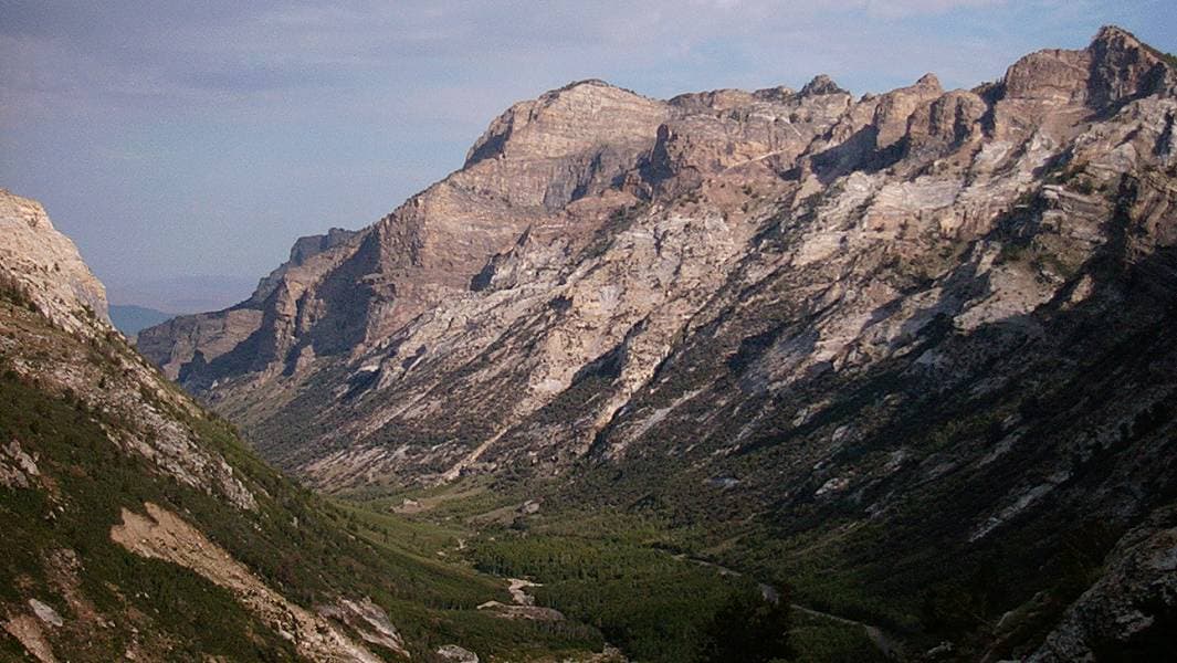
The Ruby Mountains rise without apology from Nevada's high desert, their glacial canyons cutting straight to the kind of silence you can hear. This two-day solo route threads Lamoille Canyon's alpine drama and Thomas Canyon's rugged granite, timed for cool mornings and long golden light before summer's afternoon storms roll in.
At a Glance
Highlights
- Sunrise solitude at Road's End Trailhead before the crowds arrive
- Granite amphitheaters carved by ancient glaciers
- Alpine lake reflections at Lamoille Lake
- Wildflower meadows blooming in high summer
- Thomas Canyon's dramatic switchback views
- Thin, crisp mountain air above 9,000 feet
- A backcountry escape with almost no cell signal
Day-by-Day Plan
Day 1: First Light in Lamoille Canyon
A gentler orientation day easing into altitude with a scenic drive and moderate canyon walking, roughly 3-4 miles total on foot.
The drive up Route 227 climbs steadily until the canyon opens into a glacial amphitheater so vast it makes conversation feel unnecessary. Arrive by 7:30 AM and the Road's End area is nearly empty—just you, the whisper of wind through whitebark pine, and granite walls catching the first orange light. A moderate walk toward Lamoille Lake rewards with still water mirroring Liberty Peak, and by late morning wildflowers in the meadows are just opening to the sun.
Cool air and low light greet the drive up Route 227, the road switching back through sagebrush foothills before the canyon walls close in overhead. At Road's End, the silence is almost startling—granite rising a thousand feet on either side, snowmelt roaring somewhere out of sight. A walk toward Lamoille Lake feels like entering a held breath, wildflowers scattered through the meadow grass and the lake itself lying flat and cold, holding the mountain's reflection.
By early afternoon, thin clouds often begin building over the peaks, a cue to head back down before any thunder arrives. The drive back toward Elko offers a chance to decompress, windows down, watching the canyon shrink behind in the rearview mirror as high desert reasserts itself.
Evening settles into Elko's easier rhythm—hot showers, real walls, and the low hum of a small mining town winding down for the night. Since dining data for the canyon and immediate area is sparse in the current trip sources, plan to explore Elko's own restaurant options directly once you arrive rather than relying on anything trailside.
Day 2: Thomas Canyon's Granite Heart
A more demanding day of canyon hiking and granite scenery, covering an estimated 4-5 miles with steeper terrain than Day 1.
Arriving before 7:30 AM means the lower trailhead is yours alone—wind moving through pine, the mineral scent of snowmelt on stone, switchbacks climbing until the whole canyon opens beneath you. This is a rockier, more physical morning than yesterday's, legs working against the grade while the view expands peak by peak. By late morning, the mid-morning crowd starts filtering in, so the early start is worth the alarm.

A slower second stretch of the same canyon system lets the morning's exertion settle into quieter appreciation—resting on a granite shelf near Dollar Lakes, watching light shift across the basin, feeling the thin air in every breath. This is a good window to simply sit, eat whatever you've packed, and let the solitude do its work before the afternoon's weather risk builds.
The trail into Thomas Canyon climbs quickly, granite walls tightening around the path as switchbacks gain elevation. Wind carries the scent of pine resin and cold stone, and by the second mile the valley below has shrunk to a ribbon of green threading through grey rock. Solo hiking here feels less like solitude and more like company with the mountain itself.
After resting near Dollar Lakes, the return trip down feels lighter, gravity doing half the work while clouds begin their usual midday assembly over the peaks. The drive back toward Elko retraces the morning's route in reverse, canyon walls falling away into open sagebrush country as the afternoon heat builds below.
Back in Elko for the evening, the small city's Western character offers a warm contrast to two days of granite and wind—hot food, hot water, and a chance to sit somewhere with walls and quiet conversation. As with Day 1, specific dining recommendations for this leg aren't available in the current trip data, so it's worth exploring Elko's restaurant options once there rather than counting on anything canyon-side.
Want to tweak this trip?
Our AI planner can customize this itinerary to your exact dates, interests, and travel style.
Customize This ItineraryRestaurant details (hours, menus, availability) change frequently, and this remote region has very limited mapped dining data—confirm options directly in Elko before relying on any specific venue.
Dietary compatibility tags are general guidance. If you have severe allergies, confirm directly with the restaurant.
Travel tips are general guidance, not professional safety advice. Check government advisories and current weather forecasts before heading into the backcountry.
All prices are approximate and may vary seasonally.