2 DaysCouples4 Stops

Jemez Mountains (Los Alamos, Jemez Springs), New Mexico

2-Day Itinerary for Couples

“Steam, Stone & Caldera Sky: Two Days in the Jemez Mountains”

Steam, Stone & Caldera Sky: Two Days in the Jemez Mountains

Steam rises off travertine terraces while ponderosa pines whisper overhead, and somewhere beyond the canyon walls, an 89,000-acre volcanic caldera waits in complete silence. This is New Mexico's quiet wild heart, where the drive between stops is as unforgettable as the destinations themselves.

At a Glance

Climate & Weather
Summer days are mild and dry at elevation (7,000–11,000 ft), typically 70–85°F, but afternoon monsoon thunderstorms are common July–August. Pack layers—a light jacket for cool mornings, breathable clothing for midday sun, a packable rain shell, sturdy hiking shoes, sunscreen, and a hat; temperatures can swing 25 degrees between dawn and midday.
Getting Around
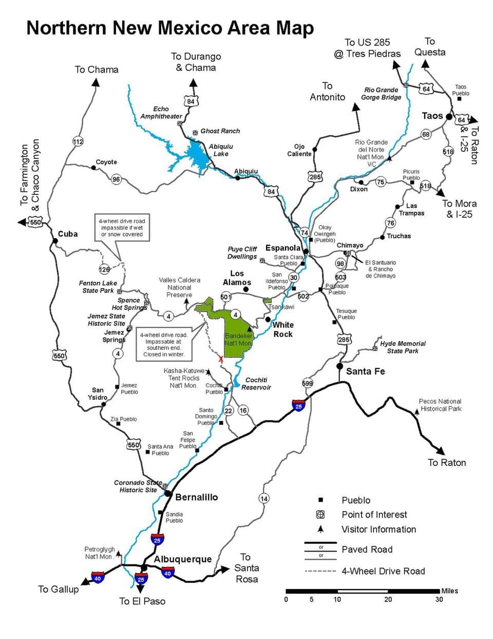
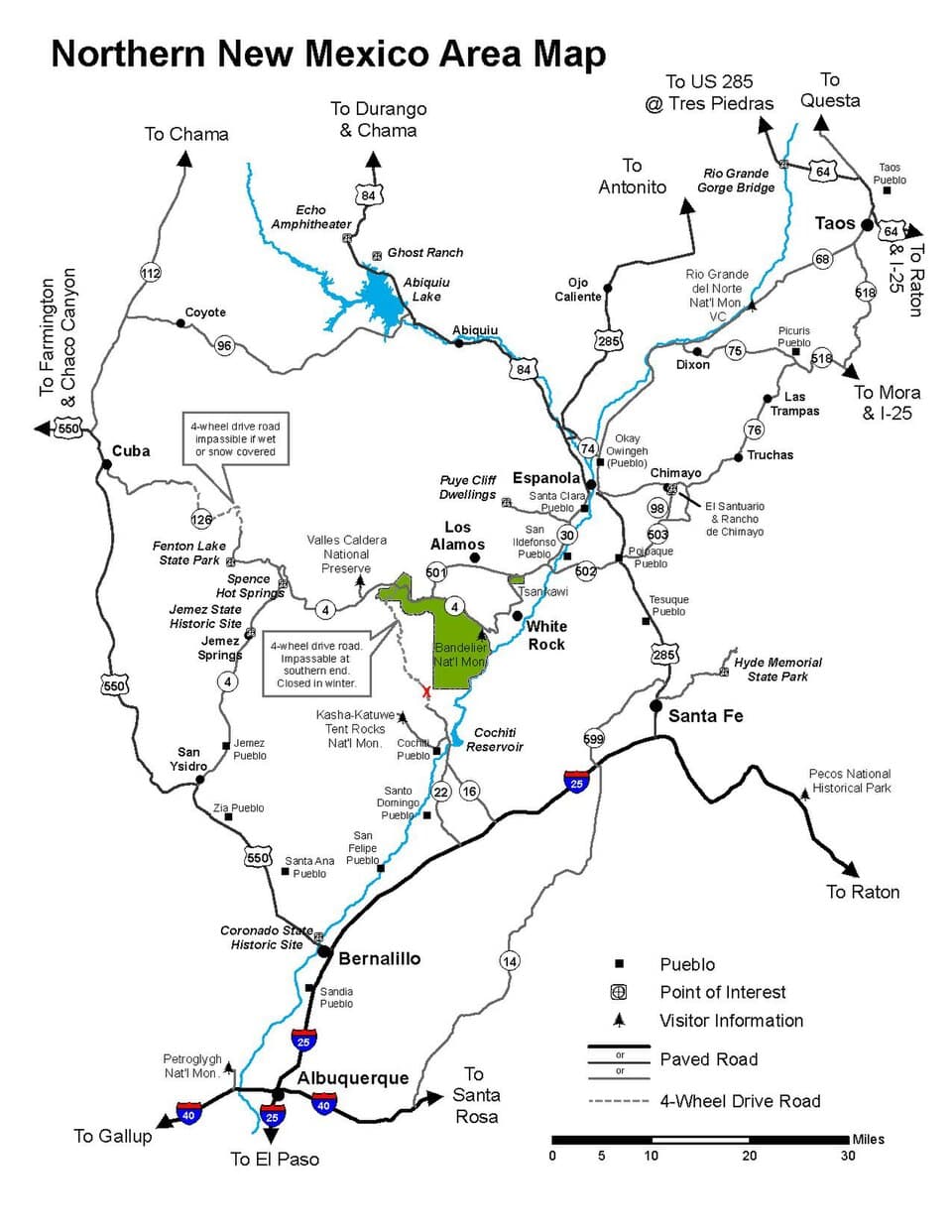
A car is essential—this is a scenic-drive destination best explored via NM-4, the Jemez Mountain Trail. Roads are paved but winding; budget extra time for photo pullovers. High-clearance isn't required for the described stops, but fill up on gas before heading into the mountains, as services thin out quickly.
Budget
Plan roughly $90–140 per day per couple for food, caldera entrance fees, and incidentals; hot springs and trail access are largely free or low-cost, making this a relatively affordable mountain escape.
Safety
Very safe for couples exploring together, but respect the mountains: start early to avoid afternoon lightning and flash flooding in canyons, carry more water than feels necessary at altitude, and give wide berth to any wildlife. Cell signal is unreliable in the backcountry, so tell someone your general plan for the day.
Connectivity
Cell coverage is spotty to nonexistent in the canyon and inside Valles Caldera—download offline maps beforehand. Los Alamos and Jemez Springs village have reliable WiFi at lodging and cafes.
Local Tips
Arrive at popular stops before 9am in summer—by mid-morning, Soda Dam and Battleship Rock trailheads fill with weekend traffic. Restaurants in this region close early, often by 8pm, so plan dinner reservations accordingly. Valles Caldera requires a (free but limited) entrance permit in peak season—reserve online in advance.

Highlights

  • Sunrise-quiet travertine formations at Soda Dam before the crowds arrive
  • Cool mist and moss at hidden Jemez Falls
  • A moderate summit hike to Battleship Rock with panoramic caldera views
  • Full immersive afternoon inside the vast Valles Caldera
  • Golden-hour light over 11,000-foot volcanic ridgelines
  • Romantic, unhurried pacing built for two

Day-by-Day Plan

Arrival & Thermal Wonders

Day 1: Steam and Stone: Easing Into the Canyon

A gentle, low-mileage day (roughly 1.5 miles walking) moving through the Jemez Springs Corridor at an easy pace to settle into mountain rhythm.

Wear
Light layers, water sandals or sturdy walking shoes for wet rock near the dam, a sunhat, and a light rain shell for afternoon clouds.
Budget
$70–100 for the couple, covering breakfast, lunch, and incidentals
8:00 AM - 9:00 AM
Soda Dam · morning · 60 min · Jemez Springs Corridor

Arrive by 8am and the milky turquoise water at Soda Dam is yours alone—no crowds, just warm mineral-scented air and birdsong bouncing off canyon walls. Trace your fingers along the cream-and-rust travertine ridges, still warm from yesterday's sun, and let the quiet set the tone for the whole trip. By 10am, weekend traffic changes the mood entirely, so this early window is worth protecting.

Soda Dam
Unknown / wikimedia (Public domain)
Shoot the main cascade from the parking area in soft early light, then move in close for mineral-layer detail shots—morning light brings out the rust tones best.
Uneven, non-flat terrain with no benches; not wheelchair accessible.
15 min drive — A short winding drive up NM-4, canyon walls narrowing before opening into pine forest.
10:00 AM - 11:15 AM
Jemez Falls · midday · 75 min · Jemez Springs Corridor

The approach trail winds through Douglas fir before the roar of falling water announces itself—cool mist rises off the plunge pool, and mossy rocks invite bare feet into the clear creek. This is an easy, unhurried romantic pause: find a flat rock, share a snack, and let the sound of water drown out everything else. Weekday mornings keep this spot blissfully quiet.

Jemez Falls
Manthey, G. Thomas United States. Bureau of Land Management. Socorro District Western Interstate Commission for Higher Education. Resources Development Internship Program / wikimedia (Public domain)
The main cascade viewing platform offers the cleanest waterfall framing; visit before 11am for soft light without harsh midday glare.
Trail is uneven and not wheelchair accessible; not recommended for those with mobility limitations.
If it rains: Heavy rain makes the approach to Jemez Falls slippery—if storms roll in, linger longer at Soda Dam instead, which tolerates light rain better, or head back to lodging early and wait out the worst of it before an evening walk.

The day begins gently, easing into mountain time with the sulfur-tinged hush of Soda Dam at sunrise. Warm mineral water has sculpted this travertine dam over centuries, and standing before it in the cool morning air—before any other visitors arrive—feels like being let in on a quiet secret.

From the dam, a short scenic drive climbs into denser forest toward Jemez Falls, where the pace shifts from stillness to sensory immersion: rushing water, cool mist, and the deep green smell of wet earth. This is a slower, more textural stop—ideal for lingering hand in hand along the creek rather than rushing to the next thing.

With no verified dining options mapped directly to these trailside stops, plan your meals around the village center rather than the canyon itself—ask your lodging host for their current favorite spot, as small family-run cafes here often shift hours seasonally. Settle into an early, unhurried evening; most kitchens in this region close by 8pm, so aim to be seated well before dusk.

Summit Views & Caldera Vastness

Day 2: Into the Volcano's Heart

A moderately active day (roughly 3–4 miles walking) climbing a volcanic landmark before spending the afternoon immersed in the vast Valles Caldera.

Wear
Sturdy hiking shoes, moisture-wicking layers, a warm layer for caldera wind, sunscreen, and a packable rain shell for likely afternoon storms.
Budget
$80–120 for the couple, including caldera fees, lunch, and dinner
20 min drive — A scenic climb north along NM-4, the canyon widening into open volcanic country as the road gains elevation.
7:30 AM - 9:30 AM
Battleship Rock · morning · 120 min · Battleship Rock & Scenic Byway

Arrive by 7:30am and the saddle trail is nearly empty, just the two of you against wind-scoured stone and impossibly blue sky. The climb is moderate but rewarding—sage and high-altitude pine scent the air, and from the summit, the full sweep of the Jemez range unfolds toward Valles Caldera. By mid-morning the trailhead lot fills fast, so this early start protects both the solitude and the light.

Battleship Rock
Tacoma Commercial Club and Chamber of Commerce / wikimedia (Public domain)
Shoot the panoramic sweep from the summit at sunrise for the clearest light and coolest air; the saddle approach also frames the Valles Caldera beautifully looking north.
Not recommended for those with mobility limitations due to trail difficulty and uneven terrain.
25 min drive — A quiet stretch of NM-4 climbing higher still, forest thinning until the caldera opens up all at once like a held breath.
11:00 AM - 3:00 PM
Valles Caldera NPS · afternoon · 240 min · Valles Caldera

The scale here defies expectation—an 89,000-acre volcanic bowl ringed by 11,000-foot peaks, with elk bugling somewhere far across the open meadow. Drive the scenic loop, pause at the main overlook, and walk the short Restless Geysers Trail together for close-up geothermal detail against a backdrop of endless grassland. This is the trip's splurge experience in spirit if not in cost—an unhurried, awe-filled afternoon that rewards slowing all the way down.
Valles Caldera NPS
U.S. National Park Service, restoration/cleanup by National Park Maps (https://npmaps.com) / wikimedia (Public domain)
The main overlook is best in late afternoon light around 4-5pm, when long shadows define the caldera's ridgelines—linger if your schedule allows.
Visitor center and main overlooks are wheelchair accessible via the scenic loop drive, though trails themselves are uneven with sparse benches.
Optional detour: Jemez Falls — Between Battleship Rock and Valles Caldera NPS
A short return detour offers a cooler, quieter contrast to the exposed heat of the summit hike if you have extra time before entering the caldera. Skip if: Skip if you've already visited on Day 1 or want to preserve energy and daylight for the full caldera experience.
If it rains: If afternoon thunderstorms roll in, retreat to the Valles Caldera visitor center for indoor exhibits and interpretive programs, and avoid Battleship Rock's exposed summit entirely during lightning—reschedule the hike for early the following morning if possible.

The day opens with ambition: a moderate climb up Battleship Rock while the air is still cool and the trail still empty. Reaching the summit as the sun climbs higher, the volcanic wilderness spreads out below in every direction—the kind of view that quiets conversation.

From the rock's summit, the drive north delivers one of the trip's most dramatic transitions: forest gives way suddenly to the vast open bowl of Valles Caldera. The pace shifts from physical exertion to quiet wonder—slow driving, short walks, and long pauses to watch light move across the meadow.

No verified dining options are mapped directly to the caldera or summit trailheads, so plan dinner back toward town rather than expecting options at the trailhead—pack a cooler with drinks and snacks for the drive, and ask locally for current dinner recommendations, as small mountain kitchens here shift seasonally and often close early, by 8pm.

Want to tweak this trip?

Our AI planner can customize this itinerary to your exact dates, interests, and travel style.

Customize This Itinerary
Good to Know

Restaurant details (hours, menus, availability) change frequently, and this itinerary intentionally omits dining recommendations where no verified data exists near a stop—check current local options before visiting.

Dietary compatibility tags are general guidance. If you have severe allergies, confirm directly with any restaurant before dining.

Travel tips are general guidance, not professional safety advice. Check government and NPS advisories for current conditions, especially regarding flash floods and afternoon storms.

All prices are approximate and may vary seasonally.
We use cookies to improve your experience and analyze site usage. Essential cookies are always active. You can customize your preferences or accept all cookies. Cookie Policy