4 DaysCouples6 Stops

Blue Ridge Highlands (Bristol, Abingdon), Virginia

4-Day Itinerary for Couples

Ridgeline & Rail-Trail: Four Days in the Blue Ridge Highlands

Ridgeline & Rail-Trail: Four Days in the Blue Ridge Highlands

High meadows hum with insects and wind here, and somewhere beyond the tree line a pony snorts and shifts its weight in tall grass. This is a trip built for two — long views, longer silences, and evenings that end early because the mountains ask you to sleep well and rise before the heat does.

At a Glance

Climate & Weather
Summer here runs mild to warm at elevation (mid-70s°F on the ridges, warmer in town) with the chance of afternoon thunderstorms rolling in fast over open meadows. Pack light layers, a packable rain shell, sturdy broken-in hiking shoes, and sun protection for exposed high-elevation stretches.
Getting Around
A car is essential — distances between Grayson Highlands, Mount Rogers trailheads, and the Creeper Trail corridor are rural and unlit at night. Roads are well-maintained in summer; download offline maps before heading into the highlands.
Budget
Budget roughly $120–180 per day per couple for meals and activities, including one splurge dinner; trail access and state park day-use fees are minimal, with bike rental and shuttle costs the main added expense.
Safety
This is low-risk, high-trust country — the main hazards are weather and wildlife etiquette. Never approach or feed the wild ponies at Grayson Highlands; keep a respectful distance and let them move at their own pace. On Mount Rogers, descend immediately if thunder rolls in — the summit and exposed ridgelines carry real lightning risk.
Connectivity
Cell service is spotty to nonexistent on the higher trails and deep in the Creeper Trail's forested sections — download maps and let someone know your plan before setting out. Signal returns reliably in Bristol, Abingdon, and Damascus.
Local Tips
Start hikes and trail rides by 7:30–8am in summer — both to beat the heat and to have ponies and trestles to yourselves before weekend crowds arrive. Dinner reservations matter, since many kitchens stop seating by 8:30–9pm; book the splurge night ahead of arrival.

Highlights

  • Wild ponies grazing free on Wilburn Ridge at golden hour
  • Sunrise solitude atop Virginia's highest point
  • A gravity-fed coast down 17 miles of restored rail-trail through hemlock and creek light
  • Trestle bridges and Laurel Creek crossings made for slow, deliberate photography
  • Small-town Appalachian evenings with live music and early, unhurried dinners
  • A splurge night in Abingdon's arts-steeped historic core

Day-by-Day Plan

Arrival & Orientation

Day 1: Settling Into the Highlands

A gentle arrival day with one easy meadow walk and an early, unhurried dinner — about 2 miles of easy walking, low exertion.

Wear
Comfortable layers, light jacket for evening mountain air, walking shoes rather than technical boots.
Budget
$90–130 for two, including dinner and light snacks
4:00 PM - 6:00 PM
Grayson Highlands (wild ponies) · afternoon · 120 min · Mount Rogers & Grayson Highlands

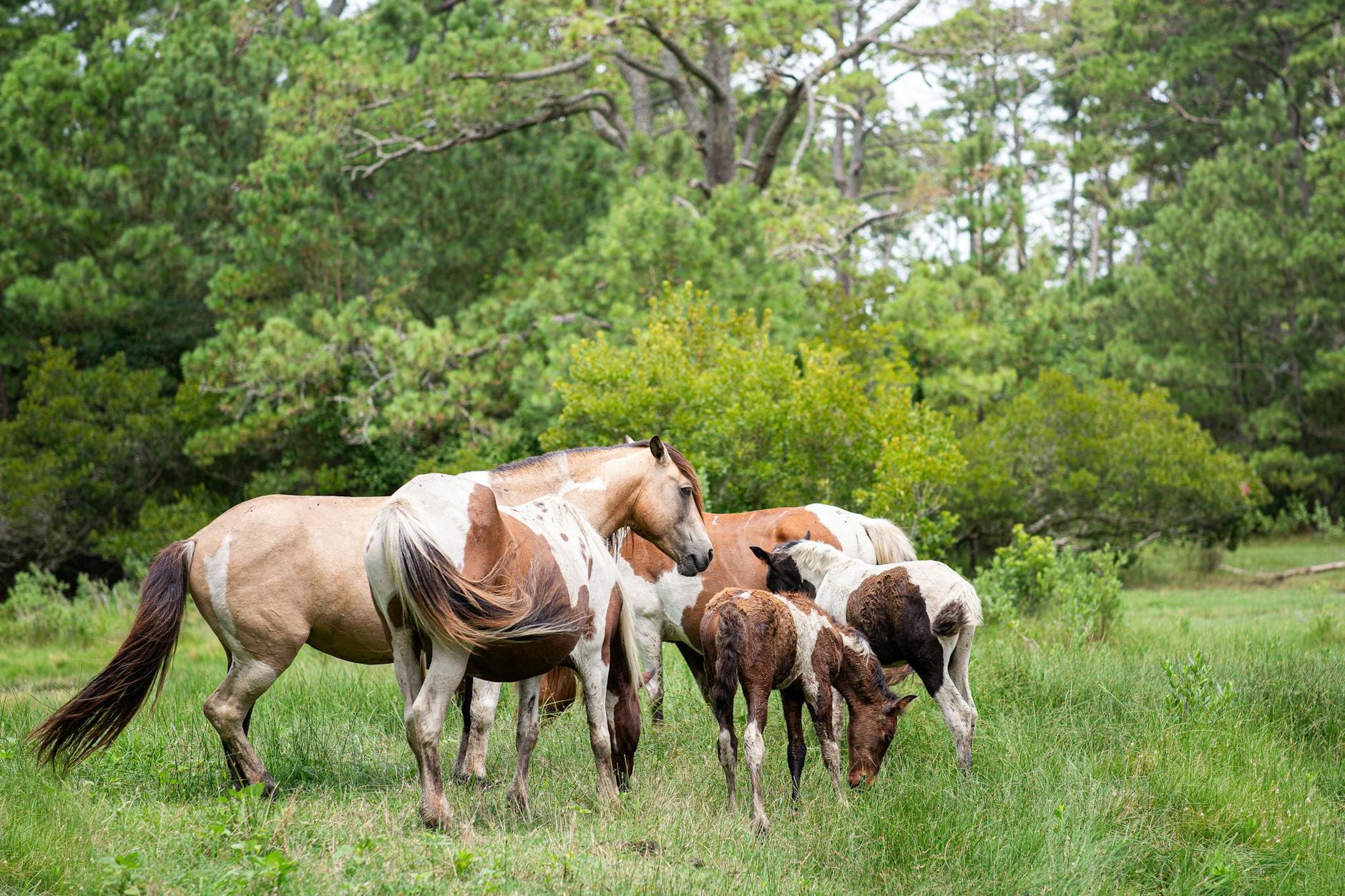
After hours in the car, this is the release valve — wide-open highland meadows, wildflowers nodding in the breeze, and if you're lucky, a small band of ponies grazing unbothered a few dozen yards off the Stamped Ground Trail. Afternoon light here is soft and long, ideal for settling in without the intensity of a full hike. Keep voices low and cameras ready; the ponies move on their own schedule, not yours.

Grayson Highlands (wild ponies)
Boys in Bristol Photography / pexels (Pexels License)
Late afternoon light rakes low across the meadows — aim for the lower grazing areas around 5:30 PM when ponies are most active and the haze on distant ridgelines turns gold.
Trails here are unpaved and uneven with minimal benches; comfortable footwear is enough for a short loop, but this isn't wheelchair accessible.
If it rains: If storms roll through, trails become slick and ponies retreat to cover — treat this as a driving/orientation day instead and plan to return to Grayson Highlands on a clearer morning later in the trip.

Travel day — most of daylight hours are spent making the drive into the highlands via I-81 and US Route 11, with the historic byway itself offering a scenic, unhurried introduction to the region's ridges and farmland.

By late afternoon, the first taste of the highlands arrives at Grayson Highlands, where an easy meadow walk among wildflowers and grazing ponies eases you into mountain time without demanding much of tired legs.

Dinner tonight should be simple and early, in keeping with the local rhythm — small-town kitchens here favor 5:30–8 PM seating, and an early night sets up tomorrow's pre-dawn start on Mount Rogers.

High Mountain Ascent

Day 2: Summit Silence

A full-day, intense hike toward Virginia's highest point with a shorter afternoon wind-down — roughly 6-8 miles round trip, high exertion.

Wear
Layered technical clothing (temperatures at elevation run cooler than the valley), waterproof shell, broken-in hiking boots, sun hat, and plenty of water — there's no reliable resupply on the mountain.
Budget
$60–100 for two, mostly food and trail snacks
25 min driveA short morning drive along quiet highland roads, mist still clinging to the lower meadows as the sun clears the ridge.
7:00 AM - 1:00 PM
Mount Rogers · morning · 360 min · Mount Rogers & Grayson Highlands

This is the day's centerpiece — a demanding, quietly euphoric push through dense spruce-fir forest that thins into wind-scoured rock near the summit. Arrive at the trailhead by 7am and the popular routes are nearly empty; by mid-morning on a summer weekend, parking lots fill and the solitude thins with them. The reward is less a single view than a rhythm — cold air, filtered light, and long stretches where the only sound is your own footfall and distant wind moving across ridgelines.

Mount Rogers
Famartin / wikimedia (CC BY-SA 4.0)
The summit cairn framed against layered ridgelines works best in the flat, clear light of mid-morning before haze builds; rhododendron blooms along the Wilburn Ridge approach add color if visiting in late June.
Unpaved, steep, and uneven throughout — not accessible for those with mobility limitations; benches are essentially nonexistent on the ascent.
20 min walkA short descent back through the same highland trail network, the forest opening gradually back into meadow.
2:30 PM - 4:00 PM
Grayson Highlands (wild ponies) · afternoon · 90 min · Mount Rogers & Grayson Highlands

After the exertion of the summit, this second, lighter pass through Grayson Highlands feels almost meditative — legs tired, pace slower, and the meadows now familiar rather than new. This is a good window to simply sit on a rock outcrop, share water, and watch ponies move across the middle distance without the pressure of a full hike ahead.

Grayson Highlands (wild ponies)
Boys in Bristol Photography / pexels (Pexels License)
Wilburn Ridge overlook is especially striking in the softer 3–4 PM light, before the harsher midday sun but well ahead of full sunset.
Same uneven, unpaved terrain as the morning; benches are sparse throughout.
Optional detour: Grayson Highlands (wild ponies)Between the Mount Rogers descent and evening return to lodging
A slower, low-effort way to decompress after a demanding summit hike while still being immersed in the same wild landscape. Skip if: If legs are truly spent, skip the second pass and head straight back to rest — the ponies will still be there another day.
If it rains: Thunderstorms on an exposed summit are genuinely dangerous — if weather turns, descend immediately and redirect the day toward Grayson Highlands State Park's lower, covered facilities until conditions clear.

Pre-dawn quiet gives way to a long, physical climb through spruce-fir forest and open rock toward Mount Rogers' summit — cold air, thinning trees, and a hard-earned sense of scale as Virginia's highest terrain opens up around you.

The pace slows deliberately on the way back down, with a second, gentler pass through Grayson Highlands' meadows offering a chance to simply sit with the view and watch ponies graze in softer afternoon light.

Tired legs and quiet conversation set the tone for an early dinner near your lodging in the Grayson Highlands / Mount Rogers vicinity — plan for something simple and close by rather than another long drive, and expect an early lights-out after the day's exertion.

Scenic Descent

Day 3: Down the Rail-Trail

A moderate, scenic cycling or walking day along the Virginia Creeper Trail — roughly 3-4 hours on trail, moderate exertion with a gentle downhill grade.

Wear
Breathable layers for temperature shifts between open meadow and shaded forest, closed-toe shoes suited to cycling, and a light rain layer given summer's afternoon storm pattern.
Budget
$100–150 for two, including bike rental/shuttle and meals
45 min driveA relaxed highland drive with a worthwhile pullover near Whitetop's open meadows, where ridge lines stretch out in every direction — a good midpoint stretch before the trailhead.
8:00 AM - 12:00 PM
Virginia Creeper Trail · morning · 240 min · Virginia Creeper Trail Corridor

Starting near Whitetop and coasting gradually downhill toward Damascus, this stretch of restored rail-trail is pure sensory ease after two days of mountain exertion — gravel crunching softly underfoot or under tires, Laurel Creek rushing somewhere just out of sight, and rhododendron and hemlock closing overhead in cool green light. Restored trestles offer some of the trip's most dramatic, engineered-meets-wild photo opportunities, and an 8am start means empty trestles and soft morning light before weekend cyclists arrive in force.

Virginia Creeper Trail
Kessler, Winifred B United States. Forest Service. Alaska Region / wikimedia (Public domain)
Photograph the trestles between Abingdon and Damascus in early morning light, when mist often still clings to the creek and the wooden structures catch a warm, low glow.
The trail surface is unpaved gravel and not wheelchair accessible; flatter sections nearer Abingdon offer the gentlest grade if mobility is a concern.
Optional detour: Virginia Creeper TrailMidway through the morning ride, near the Whitetop approach
The open meadows and ridge-line views at this section offer a natural rest stop and a change of visual texture from the forested sections. Skip if: If time is tight or legs are tired from the previous day's summit hike, continuing directly toward Damascus keeps the day shorter and less demanding.
If it rains: Rain turns the gravel trail muddy and slick, especially on the steeper upper sections — if storms move in, shift the day toward exploring Damascus's shops and casual eateries instead of continuing the ride.

The morning belongs to gravity and green light — a long, gentle downhill glide or walk along the Virginia Creeper Trail from Whitetop toward Damascus, past trestles, creek crossings, and meadow openings that reward an early start with near-empty trail and soft light.

By midday, the trail delivers you into Damascus itself, where the pace shifts naturally from motion to rest — a good afternoon for wandering the small trail-town at an unhurried pace, letting muscles recover from the morning's ride.

Keep dinner low-key and close to town tonight, honoring the early local dining rhythm, and consider an early turn-in to rest ahead of tomorrow's final day exploring Abingdon's historic core.

Arts & Departure

Day 4: Abingdon's Quiet Elegance

A relaxed, low-exertion final day centered on Abingdon's historic core, with the trip's signature splurge dinner — under 2 miles of easy walking.

Wear
Comfortable but slightly dressier evening wear for the splurge dinner, with easy walking shoes for daytime wandering.
Budget
$150–220 for two, reflecting the splurge dinner and any theater tickets
50 min driveA relaxed drive back from Damascus toward Abingdon, the road tracing the same valley the trail follows, ridgelines softening into farmland as elevation drops.
8:30 AM - 10:30 AM
Virginia Creeper Trail · morning · 120 min · Virginia Creeper Trail Corridor

A short, flat, unhurried final walk along the Abingdon-adjacent section of the trail closes the loop gently — this stretch is calmer and more accessible than the trestle-heavy upper sections, ideal for a slow morning without the intensity of a full ride. Early light filters through trailside trees, and the pace here is entirely your own.

Virginia Creeper Trail
Kessler, Winifred B United States. Forest Service. Alaska Region / wikimedia (Public domain)
The flatter Abingdon-side sections are best photographed mid-morning when light filters evenly through the tree canopy without harsh midday contrast.
This section near Abingdon is the flattest and most accessible stretch of the entire trail, though still unpaved gravel rather than a paved path.
If it rains: If rain sets in, shift the morning entirely toward Abingdon's historic downtown core and the Barter Theatre area, both well-suited to a slower, covered exploration.

The final morning eases off the throttle entirely — a short, flat walk along the gentlest section of the Virginia Creeper Trail near Abingdon, quiet and unhurried, a fitting bookend to the trip's more demanding mountain days.

The afternoon is best spent wandering Abingdon's historic streets at whatever pace feels right — this is a town built for slow looking, with its Appalachian arts heritage and quiet, walkable core rewarding unstructured time together.

Save the trip's splurge experience for tonight: book ahead for an upscale dinner in Abingdon's historic core, where an intimate atmosphere, a thoughtful wine list, and regionally rooted dishes make for a fitting close to four days spent between wild ridgelines and rail-trail light — plan for an early-to-mid evening seating in keeping with the town's unhurried dining hours.

Want to tweak this trip?

Our AI planner can customize this itinerary to your exact dates, interests, and travel style.

Customize This Itinerary
Good to Know

Restaurant details (hours, menus, availability) change frequently. Check current hours before visiting, especially in seasonal destinations.

Dietary compatibility tags are general guidance. If you have severe allergies, confirm directly with the restaurant.

Travel tips are general guidance, not professional safety advice. Check government advisories for latest information.

All prices are approximate and may vary seasonally.
We use cookies to improve your experience and analyze site usage. Essential cookies are always active. You can customize your preferences or accept all cookies. Cookie Policy