4 DaysSolo Traveler9 Stops

Driftless Area (Southwest), Wisconsin

4-Day Itinerary for Solo Traveler

“Bluffs, Caves & Frozen River Valleys: 4 Days Alone in the Driftless”
Bluffs, Caves & Frozen River Valleys: 4 Days Alone in the Driftless

Winter strips the Driftless Area down to its bones—bare limestone bluffs, black river water threading through white valleys, and a quiet so complete you can hear your own footsteps on frozen gravel. This is a landscape built for solo travelers: no lines, no crowds, just ancient rock and the particular clarity of a cold Wisconsin morning.

At a Glance

Climate & Weather
Expect cold, dry air with highs often in the 20s–30s°F and lows well below freezing; snowfall of 17–40cm is common December–March. Pack insulated waterproof boots, wool base layers, a heavy shell, hat, gloves, and microspikes or trail cleats for icy overlooks.
Getting Around
A car is essential—distances between clusters can run 30-60+ minutes on two-lane roads through valleys and ridgetops. Roads are generally well-plowed on main routes, but secondary roads near state parks can be slower to clear after snowfall; check road conditions each morning before setting out.
Budget
Budget roughly $60-90/day for a solo traveler—hearty tavern meals run $12-20, Cave of the Mounds admission is around $22, and state park vehicle passes are about $8-13/day for non-residents.
Safety
This is quiet rural terrain with very low crime, but winter driving on narrow, hilly roads demands caution—watch for black ice, reduce speed on curves, and never rely solely on cell signal for navigation. Deer are highly active at dawn and dusk, especially on rural highways. As a solo traveler, tell someone your day's route, carry a car emergency kit (blanket, snacks, charger), and avoid unmarked trails after dark since daylight ends early in winter.
Connectivity
Cell coverage is spotty in river valleys and inside coulees but generally reliable on ridgetops and in towns like Dodgeville and Prairie du Chien. Download offline maps before heading into Governor Dodge or Wyalusing, and don't count on signal at trailheads.
Local Tips
Winter is genuinely the quiet season here—most restaurants close by 8pm and many shut entirely on Mondays, so plan dinner early. Arrive at outdoor viewpoints right at sunrise for both the best light and total solitude, since almost no one else is out before 9am in January. Bar seating at local taverns is the easiest way to strike up conversation with regulars who know the land better than any guidebook.

Highlights

  • Underground warmth inside Cave of the Mounds while snow falls outside
  • Sunrise over Cox Hollow Lake with the whole overlook to yourself
  • Frozen bluff-top views of the Mississippi–Wisconsin confluence at Wyalusing
  • Quiet riverside towns in the Kickapoo Valley with almost no winter tourists
  • Hearty tavern dinners built for solo bar seating and easy conversation
  • Golden-hour light on rust-red cliffs along a nearly empty river corridor

Day-by-Day Plan

Arrival & Orientation

Day 1: Settling Into the Silence: Dodgeville & Underground Wonder

A gentle first day mixing an easy underground cave tour with light exploration of Governor Dodge's snow-quiet trails, covering roughly 2-3 miles on mostly flat terrain.

Wear
Warm layers with a windproof outer shell, insulated waterproof boots, wool socks, and gloves you can still operate a camera in; bring a lighter layer for the cave's mild interior temperature.
Budget
$45-65 including cave admission, park pass, and two meals
9:30 AM - 11:00 AM
Cave of the Mounds · morning · 90 min · Governor Dodge & Dodgeville

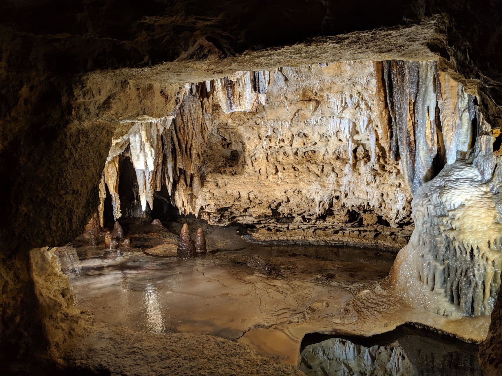
Descend into a world untouched by the cold above—cool, mineral-scented air wraps around you as calcite formations catch the low light like frozen chandeliers. Arrive right at opening and you'll likely have entire chambers to yourself, footsteps echoing off stone in a way that feels almost private. This is the perfect first-day activity: low physical demand, high sensory reward, and a gentle reintroduction to travel mode after the drive in.

Cave of the Mounds
Photo by Manju Raj on Pexels
The main chamber's illuminated crystal formations photograph best with a tripod-free long exposure—brace against the railing for stability in the dim light.
Cave paths include uneven, sometimes narrow stone walkways; not fully wheelchair accessible, but manageable at a slow pace.
25 min drive — A short country drive past snow-dusted farmland and grazing cattle, the road curving gently through low hills.
12:30 PM - 3:00 PM
Governor Dodge SP · afternoon · 150 min · Governor Dodge & Dodgeville

Above ground again, the park feels almost sculptural in winter—bare limestone cliffs rise over a frozen Cox Hollow Lake, and the crunch of snow underfoot replaces summer's gravel trails. Stick to shorter, flatter loops near the lake rather than the more technical Lost Valley Trail, which can be icy and treacherous this time of year. Solitude here is nearly guaranteed on a weekday afternoon—this is a place to walk slowly, breathe cold air, and let the quiet do its work.

Governor Dodge SP
United States. Agricultural Marketing Service / wikimedia (Public domain)
The Cox Hollow Lake overlook works beautifully in flat winter light around 2-3pm, when the ice and sky both take on a soft pewter tone.
Main overlook areas are reachable via packed paths, but expect uneven or icy footing away from the parking areas.
If it rains: If wet weather or ice makes trails unsafe, spend extra time at Cave of the Mounds—it's fully indoors and weatherproof—or linger in Dodgeville's small shops and warm cafes before heading to the park for just a short overlook visit.

Ease into the trip underground, where Cave of the Mounds offers a low-key, weatherproof welcome to the Driftless. The temperature holds steady no matter what's happening outside, and the hush of the chambers makes for a meditative first stop—ideal for a solo traveler shaking off travel fatigue.

Above ground, Governor Dodge State Park trades the cave's intimacy for wide-open winter drama: frozen lake, bare bluffs, and total quiet. Keep the pace easy and the trails short, letting the cold, clean air and long sightlines reset your internal clock after the journey in.

With early sunset settling over Dodgeville by late afternoon, plan for a quiet dinner in town and an early night—small local restaurants here tend to close by 8pm, and this is the kind of place where an early bedtime after a long travel day feels like part of the experience rather than a compromise.

River Valley & Solitude

Day 2: River of Rust and Silence: The Kickapoo Valley

A full day centered on the Kickapoo River corridor, covering roughly 3-4 miles across scenic overlooks and quiet valley walks with light-to-moderate energy demands.

Wear
Heavy insulated layers, waterproof boots with good tread for icy riverbanks, a warm hat and neck gaiter, and hand warmers for extended outdoor photography stops.
Budget
$35-55 for meals and incidental stops; no major admission fees
55 min drive — A winding country drive through rolling farmland and small unincorporated towns, the road dipping in and out of river valleys—watch for deer especially near dawn.
9:00 AM - 11:00 AM
Kickapoo River · morning · 120 min · Kickapoo River Valley

In winter, the Kickapoo takes on a stark, almost monochrome beauty—dark open water threading between ice shelves, rust-red cliffs standing bare against gray sky. Arrive early and the valley feels entirely yours; a bald eagle overhead or the crunch of your boots on frosted gravel may be the only sounds for an hour. This is prime solo-traveler territory: no crowds, no rush, just space to wander the overlooks near Readstown and let the scale of the place sink in.
Kickapoo River
Unknown / wikimedia (Public domain)
The bluffs north of Readstown catch dramatic side-lighting in mid-morning, when low winter sun rakes across the rock face and highlights every ledge and crevice.
Riverside paths are unpaved and can be icy or muddy; sturdy footwear with traction is essential.
20 min drive — A short hop along the river road, crossing narrow bridges with the water visible below through bare tree branches.
1:00 PM - 3:00 PM
Kickapoo River · afternoon · 120 min · Kickapoo River Valley

Shift to the bridge at Ontario for a different vantage—here the gorge frames the water in a way that feels almost architectural, ice forming delicate patterns along the banks. Take this half of the day slower: wander into Soldiers Grove or Gays Mills for a warm coffee and a look at the area's small bohemian arts scene, a nice contrast to the morning's wilder scenery. Solo travelers will find these towns unpretentious and easy to strike up conversation in, especially at local counters and shops.

Kickapoo River
Unknown / wikimedia (Public domain)
The bridge at Ontario offers classic gorge framing—come in early afternoon when the light angles directly down the river corridor.
Bridge viewpoints are accessible by short walks from roadside parking, though surfaces may be icy in winter.
Optional detour: Kickapoo River — Between the morning Readstown overlooks and the afternoon Ontario bridge stop
A quiet detour to a shallow-pool boat launch area can offer striking reflection photography if conditions are calm. Skip if: Skip this if temperatures have dropped sharply or the light is flat—overcast midday skies won't reward the extra stop.
If it rains: If icy rain or heavy snow makes riverside walking unsafe, retreat to the small-town shops and cafes of Soldiers Grove or Gays Mills, using the day to explore indoor galleries and warm up between short, careful stops at roadside overlooks accessible directly from the car.

The day opens along the Kickapoo's wilder stretches near Readstown, where winter silence and stark cliff-and-water contrast make for one of the most striking solo photography opportunities in the region. Go early, dress warm, and give yourself time to simply stand still.

The pace softens in the afternoon as the route shifts toward Ontario's bridge and the small riverside towns nearby—more approachable, more social, with warm indoor stops offering a break from the cold and a chance to chat with locals who clearly love this valley.

As dusk falls early over the coulees, head toward a local tavern for dinner—this is prime territory for bar-seat dining, where solo travelers can settle in among regulars and hear stories about the river in every season. Plan to wrap the evening by 8 or 9pm, since small-town Wisconsin dining rooms empty out early.

Confluence & Bluff-Top Drama

Day 3: Where Two Rivers Meet: Wyalusing's Frozen Heights

A moderately paced day exploring Wyalusing State Park's bluff trails and mound sites, covering roughly 3-4 miles with some elevation change on packed winter trails.

Wear
Insulated waterproof hiking boots with traction devices for icy overlooks, layered clothing for temperature swings between exposed bluffs and sheltered forest, and a warm hat for wind exposure at the ridge.
Budget
$40-60 including park admission and meals
8:30 AM - 11:00 AM
Wyalusing State Park · morning · 150 min · Wyalusing & Prairie du Chien

Arrive at first light and the Tower Hill overlook delivers one of the Driftless Area's most dramatic sights in complete solitude—500-foot bluffs falling away to the confluence of the Mississippi and Wisconsin Rivers, mist rising off the open water even in deep cold. By 9am you'll likely still be the only person up here, the silence broken only by wind and the occasional hawk's cry. This is a rare kind of solo travel moment: vast, humbling scenery experienced without a single other person in view.

Wyalusing State Park
Delaware Valley Milk Marketing Area. Market Administrator / wikimedia (Public domain)
Tower Hill bluff overlook is best at sunrise—the low sun catches river mist and ice in a way that transforms by midday into flatter, less dramatic light.
Trails to the main overlooks involve some uneven terrain and are not fully wheelchair accessible; icy conditions require caution and traction devices.
15 min walk — A short walk along the ridge trail connecting the overlook to the mound area, snow squeaking underfoot in the cold.
11:15 AM - 12:30 PM
Wyalusing State Park · midday · 75 min · Wyalusing & Prairie du Chien

Shift focus to the park's prehistoric mound clusters, quieter and more contemplative than the bluff overlook—snow softens the contours of these ancient earthworks, and interpretive signage (or the visitor center, if trails are icy) offers context on the tribal history embedded in this land. It's a slower, more reflective stop that pairs well after the morning's big vista, giving the day some rhythm rather than back-to-back high-intensity hikes.

Wyalusing State Park
Delaware Valley Milk Marketing Area. Market Administrator / wikimedia (Public domain)
Prehistoric mounds photograph well in soft afternoon light, their low forms catching subtle shadow definition in winter snow cover.
Mound area paths are mostly flat but can be snow-covered and slippery; the visitor center offers an accessible alternative for learning the history.
Optional detour: Wyalusing State Park — Between the Tower Hill overlook and the mound cluster visit
A short detour to a secondary confluence viewpoint offers a slightly different angle on the two rivers meeting, worthwhile for photographers wanting variety. Skip if: Skip if the wind is strong or the light has gone flat—one strong overlook experience is often enough for the morning.
If it rains: If trails turn icy or visibility drops, head to Wyalusing's small park visitor center for mound history and hardwood forest interpretation, or shelter under the picnic pavilions before making the drive into Prairie du Chien for a museum visit and warm lunch.

The day's centerpiece comes early: Tower Hill's overlook at Wyalusing, delivering sweeping views of the Mississippi–Wisconsin confluence in near-total solitude. This is the kind of sunrise moment solo travelers plan whole trips around—vast, quiet, and utterly yours.

After the drama of the bluff, the pace eases toward the park's ancient mound sites, a more contemplative counterpoint that rewards slower observation. From here, consider driving into Prairie du Chien for a look at the town's riverfront heritage and a warm indoor break from the cold.

Wind down in Prairie du Chien with an early dinner, taking advantage of the town's slightly more developed tourism infrastructure for a comfortable, low-key evening. As with the rest of the region, plan to be settled in by 8 or 9pm, since the rhythm here favors early nights over late ones.

Reflection & Departure

Day 4: Last Light on the Bluffs: A Slow Departure

A lighter final day revisiting favorite terrain in Governor Dodge or the Kickapoo Valley depending on road conditions, covering 2-3 miles at an easy pace before departure.

Wear
Comfortable warm layers suited for a shorter outdoor session, waterproof boots, and travel-ready clothing underneath for the drive home.
Budget
$25-40 for a final meal and incidental stops
8:30 AM - 10:30 AM
Governor Dodge SP · morning · 120 min · Governor Dodge & Dodgeville

Return to Governor Dodge for one last quiet walk before the drive home—this time with no agenda beyond noticing what you missed the first time. The park at this hour, in deep winter, feels almost sculptural: bare trees, frozen lake edges, cliffs holding the pale morning light. It's a gentle, low-effort way to close out a trip built around solitude and slow observation.

Governor Dodge SP
United States. Agricultural Marketing Service / wikimedia (Public domain)
Sunset from the eastern picnic area works in the evening, but for a morning visit, the Cox Hollow Lake overlook still offers the softest, most flattering light shortly after sunrise.
Stick to the main lakeside paths near parking for the most accessible, least icy walking on a shorter final visit.
Optional detour: Cave of the Mounds — Before departure, if time and route allow
A short return visit offers a warm, weatherproof way to spend an hour if outdoor conditions are poor on departure morning. Skip if: Skip if you've already toured the cave on Day 1 and prefer to maximize outdoor time before the drive home.
If it rains: If icy conditions make even a short walk unsafe, spend the final morning in Dodgeville's small shops and cafes, or revisit Cave of the Mounds for a warm, weatherproof final stop before departure.

Close the trip with an unhurried final walk at Governor Dodge, retracing familiar ground in the quiet of early morning light. There's no pressure to see something new—this is about letting the trip's rhythm settle before the drive home.

With the morning wrapped, allow time for a relaxed lunch in Dodgeville and any last-minute stops before beginning the drive toward Madison or Minneapolis-St. Paul for departure, factoring in extra time for winter road conditions.

Departure timing will vary by flight or drive distance, but plan to be well on the road before dusk, when deer activity increases on rural highways—an early, unhurried exit is safer and matches the slow, deliberate pace the whole trip has followed.

Want to tweak this trip?

Our AI planner can customize this itinerary to your exact dates, interests, and travel style.

Customize This Itinerary
Good to Know

Restaurant details (hours, menus, availability) change frequently, especially in small rural towns during winter. Check current hours before visiting.

Dietary compatibility tags are general guidance. If you have severe allergies, confirm directly with the restaurant.

Travel tips are general guidance, not professional safety advice. Check road conditions and government advisories before winter travel in this region.

All prices are approximate and may vary seasonally.
We use cookies to improve your experience and analyze site usage. Essential cookies are always active. You can customize your preferences or accept all cookies. Cookie Policy