3 DaysTeen Families8 Stops

San Francisco Bay Area (day trips), California

3-Day Itinerary for Teen Families

โ€œRedwoods, Ridgelines & Rugged Coast: 3 Days Beyond the Golden Gateโ€

Redwoods, Ridgelines & Rugged Coast: 3 Days Beyond the Golden Gate

Fog drifts through 2,000-year-old redwoods like slow-moving breath, while an hour away wind-scoured cliffs drop into a churning Pacific. This is the Bay Area beyond the skyline โ€” three days of ancient trees, alpine ridgelines, and wildflower-strewn headlands, paced for families with teenagers who want real adventure, not a museum shuffle.

At a Glance

Climate & Weather
Spring means layers, non-negotiable: mornings run cool and often damp (45โ€“55ยฐF) with a real chance of rain, while afternoons can swing sunny and mild (60โ€“65ยฐF). Wildflowers are blooming in the grasslands, but coastal fog can roll in without much warning, dropping temperatures 10-15 degrees in minutes. Pack a waterproof shell, a warm layer, and sturdy closed-toe shoes for every single day, even ones that start clear.
Getting Around
A rental car is essential โ€” this itinerary covers three separate day-trip regions (Marin, Point Reyes, Half Moon Bay), none connected by convenient transit. Roads are scenic but winding (especially CA-1 and Panoramic Highway), so budget extra time and consider motion-sickness remedies for teens prone to carsickness.
Budget
Plan roughly $80โ€“130/day per family of four for food and activities, not counting lodging or car rental โ€” this covers casual sit-down meals, coffee/snack stops, Muir Woods entrance/parking reservations (around $30โ€“40 total), and incidental beach-town shopping. Point Reyes and Mount Tam are largely free once you're there; Muir Woods requires a paid timed-entry reservation booked in advance.
Safety
All three destinations are very safe for families, but coastal bluffs and cliff edges (especially at Point Reyes, Pescadero, and Pigeon Point) have real drop-offs โ€” remind teens to stay on marked paths and away from edges, particularly in wind or wet conditions. Fog can reduce visibility fast on ridgelines like Mount Tam, so keep the group together on trails. Tide pool areas get slick; water shoes or grippy sneakers help.
Connectivity
Cell coverage is spotty to nonexistent in Muir Woods, along much of Point Reyes, and on stretches of CA-1 near Half Moon Bay โ€” download offline maps before you leave San Francisco each morning. Most towns (Mill Valley, Point Reyes Station, Half Moon Bay) have reliable WiFi at cafes for a signal check-in.
Local Tips
Book your Muir Woods entry reservation online at least a few days ahead โ€” spring weekends sell out, and there's no walk-up option. Arrive at any trailhead by 7:30-8:30am on weekends to beat both crowds and the parking crunch, especially at Muir Woods and Stinson Beach. Pack a thermos of coffee and snacks for the car โ€” trailhead food options are limited and mornings start early and cold.

Highlights

  • Sunrise light filtering through Muir Woods' cathedral grove before the crowds arrive
  • Standing atop Mount Tamalpais with the entire Bay stretched out below
  • Tule elk grazing wild along the wind-whipped spine of Tomales Point
  • Sandcastle-building and tide pooling at Stinson Beach's wide curving shore
  • Pigeon Point Lighthouse rising 115 feet over crashing surf and kelp-scented air
  • Pumpkin-patch charm and fresh seafood in Half Moon Bay's low-key harbor town
  • Teen autonomy built in โ€” beach time, harbor wandering, and trail choices along the way

Day-by-Day Plan

Ancient forest, gentle pace

Day 1: Into the Redwood Cathedral

A low-key first day easing into Bay Area rhythms with a redwood grove walk and a wide sandy beach โ€” under 3 miles of walking total, moderate energy.

Wear
Layers are key: a light base layer, a warm fleece or sweatshirt, and a waterproof/windproof shell on top. Closed-toe walking shoes with grip for damp trail sections; a beach layer change (or just roll pants) for Stinson.
Budget
$90-120 for a family of four (Muir Woods reservation fee, lunch in Mill Valley, dinner near Stinson, coffee stops)
8:00 AM - 9:30 AM
Muir Woods (early reservation) ยท morning ยท 90 min ยท Muir Woods & Mill Valley

Book the earliest reservation slot you can get โ€” by 8am the grove is nearly silent, filtered light slanting through 2,000-year-old canopy, the air thick with the smell of damp bark and earth. Teens who roll their eyes at 'nature walks' tend to go quiet here; the scale of these redwoods does the convincing for you. Stick to the Main Trail's flatter sections for an easy first taste of the forest.

Muir Woods (early reservation)
Ontario. Royal Commission on Forest Reservation and National Park / wikimedia (Public domain)
The twin redwoods near the entrance catch soft morning light beautifully before 9am โ€” after that, crowds fill the frame.
Main Trail near the entrance is boardwalk and mostly flat; deeper sections have roots and uneven grade.
5 min walk โ€” A short stroll deeper into the valley, the creek's murmur growing louder as the crowds from the entrance thin out.
9:30 AM - 10:30 AM
Redwood Creek Trail Loop (Muir Woods Extension) ยท morning ยท 60 min ยท Muir Woods & Mill Valley

Extend the morning with this gentler loop tracing Redwood Creek โ€” flat, well-benched, and quieter than the main grove, with a fern grotto tucked into the upper section that's an easy win for photos. It's a good stretch for letting teens range a little ahead on their own along the safe, well-marked path.
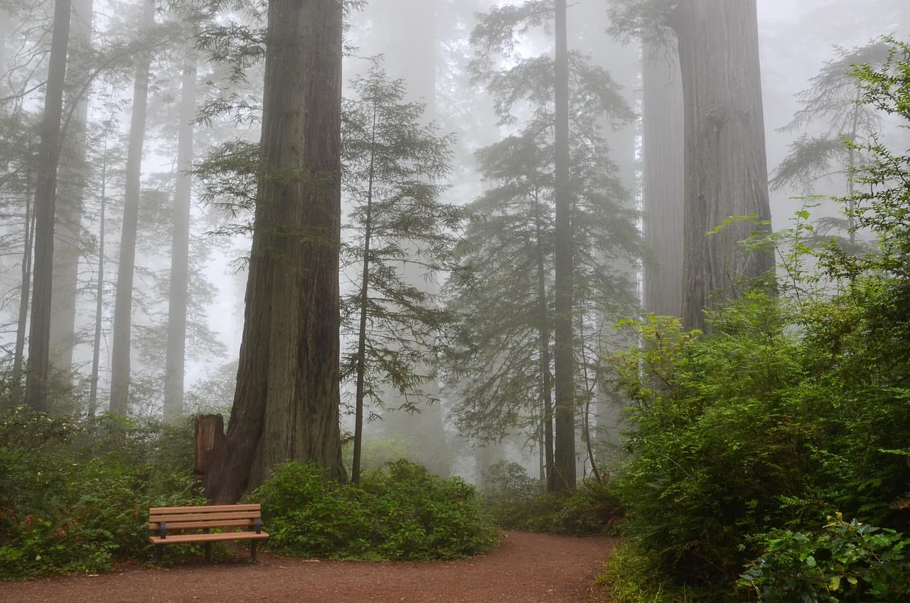
Redwood Creek Trail Loop (Muir Woods Extension)
Photo by USA-Reiseblogger on Pixabay
The main bridge over Redwood Creek is the classic shot โ€” try it just after 10am when light starts breaking through the canopy.
Flat sections of the main loop are wheelchair-friendly with benches roughly every 200m.
25 min drive โ€” A winding descent on Panoramic Highway with glimpses of the coastline appearing and disappearing through the trees.
12:30 PM - 3:30 PM
Stinson Beach ยท afternoon ยท 180 min ยท Marin Headlands & Mount Tamalpais

After the hush of the redwoods, Stinson hits like a reset button โ€” wide open sky, Pacific-sized swells crashing in, and enough sand to actually spread out. Let teens have some unsupervised wandering time toward the rocky north end where tide pools and sea stacks make for good exploring, while adults claim a spot for sandwiches. Water's cold for swimming most of spring, but wading and beachcombing are easy wins.
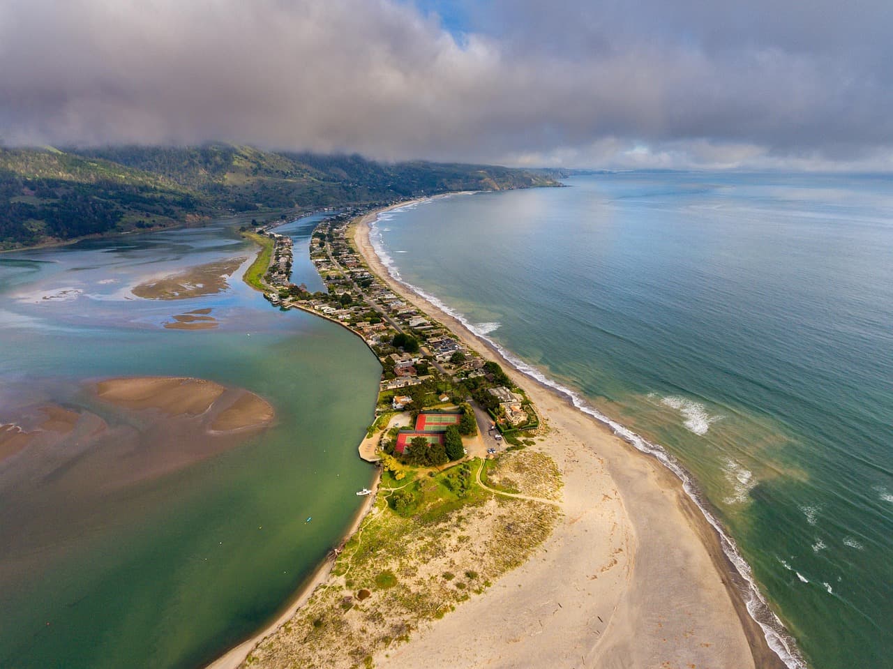
Stinson Beach
Photo by derwiki on Pixabay
Golden hour hits the southern end of the beach looking north toward the bluffs โ€” worth lingering for if your evening plans allow.
Beach access is flat and wheelchair-friendly near the main lot, though sand itself is loose underfoot.
If it rains: If rain moves in, skip Stinson Beach's exposed shoreline and instead spend the afternoon in Mill Valley's covered downtown shops and cafes, or extend time in Muir Woods โ€” the grove is genuinely more atmospheric in a light drizzle, just bring waterproof layers.

The day starts early and quiet โ€” an 8am reservation slot at Muir Woods means the grove still belongs mostly to the birds and a scattering of other early risers. Cool, damp air settles between trunks wider than a car, and the Main Trail's boardwalk makes for easy, flat walking that even reluctant teens find themselves slowing down for. From there, the Redwood Creek Trail Loop extends the morning with a gentler, creekside stretch โ€” benches every couple hundred meters, a fern grotto tucked into the upper loop, and enough space for teens to walk a bit ahead on their own without losing sight of the group.

A short, scenic drive over Panoramic Highway trades forest shadow for open coastal light at Stinson Beach, where the mood shifts entirely โ€” wide sand, real Pacific swell, and room to spread out. This is the built-in autonomy moment: teens can wander toward the tide pools at the north end while the rest of the group settles in with lunch and a book. Three hours here covers beachcombing, wading, and simply decompressing after a full morning of walking.

As the light softens, Stinson's village strip along Highway 1 offers a low-key wind-down โ€” a short walk from the sand into small shops and casual eateries before the short drive back toward your base for the night. Keep dinner easy and unstructured; day one is about settling into Bay Area rhythm, not packing in more sightseeing.

Alpine panoramas, big sky

Day 2: Ridgelines and Wide Bay Views

A moderate-energy day centered on Mount Tamalpais's summit views, covering roughly 3-4 miles of walking across short trail sections and overlooks.

Wear
Full layering system essential โ€” it can be 15 degrees colder and windier at the summit than at the trailhead. Windproof jacket, warm hat, sturdy hiking shoes with ankle support, and sunscreen even on cloudy days (UV is strong at elevation).
Budget
$70-100 for a family of four (mostly food, since Mount Tam access itself is largely free)
8:00 AM - 11:00 AM
Mount Tamalpais ยท morning ยท 180 min ยท Marin Headlands & Mount Tamalpais

Arrive at the East Peak parking area by 8am and the summit is close to yours alone โ€” by 10am, tour buses and weekend crowds fill the lot. The short walk to the top rewards with a 360-degree view stretching from the Sierra Nevada on clear days to San Francisco's skyline across the water, fog sometimes pooling in the valleys below like a second ocean. Stick to the shorter loop trails from Pantoll Ranger Station for a family-friendly version of the mountain's drama, with plenty of natural rest stops along the way.

Mount Tamalpais
Banks, Charles Eugene, 1852-1932 Read, Opie Percival, 1852-1939 / wikimedia (Public domain)
East Peak summit at sunrise is the money shot, but even mid-morning light works well for the wide bay panorama โ€” just get there before the haze thickens.
Paved overlooks near the East Peak parking area are accessible; deeper trail sections have uneven terrain and no wheelchair access.
30 min drive โ€” Panoramic Highway's switchbacks descend through shifting microclimates โ€” cool mountain air giving way to salt-tinged coastal breeze.
1:00 PM - 3:00 PM
Stinson Beach ยท afternoon ยท 120 min ยท Marin Headlands & Mount Tamalpais

Coming down off the ridge to sea level again is its own kind of relief โ€” muscles loosen, the wind softens, and Stinson's sand feels different after a morning of trail. This is a shorter, lighter visit than yesterday's, more about decompressing than exploring; good for teens who want a bit more beach time and parents who want to sit still for an hour.

Stinson Beach
Photo by derwiki on Pixabay
The rocky outcrop north of the lifeguard tower has good tide pools if timed with low tide โ€” check tide charts before heading out.
Flat, wheelchair-accessible sand access near the main parking area.
Optional detour: Redwood Creek Trail Loop (Muir Woods Extension) โ€” After Mount Tamalpais and before Stinson Beach
If the family wants one more shaded, easy walk to break up the drive down, this gentle loop offers a cool contrast to the mountain's exposed ridgelines. Skip if: Skip if you visited it on Day 1 โ€” repeating the same trail back-to-back with similar scenery risks feeling redundant, especially for teens.
If it rains: Heavy rain or thick fog at the summit erases the views that make Mount Tam worth the trip โ€” if conditions are poor, pivot the morning to Muir Woods instead (redwoods hold up beautifully in mist) or spend it exploring Sausalito's waterfront galleries and shops.

The drive up to Mount Tamalpais's East Peak trailhead is itself part of the experience โ€” switchbacks climbing through eucalyptus and chaparral before opening onto grassy ridgelines. Early arrival is the whole game here: by 8am the parking area is calm and the short summit walk feels like having the mountain to yourself, cool wind cutting across exposed granite as the entire Bay unfolds below. Shorter loop trails from Pantoll Ranger Station keep the pace family-friendly, with enough natural overlooks and rest stops to make three hours feel unhurried rather than grueling.

Descending back toward sea level, the mood shifts from alpine drama to coastal ease at Stinson Beach โ€” a shorter visit than Day 1's, more about resetting tired legs than deep exploring. Tide pools near the rocky outcrop offer a built-in scavenger-hunt feel for teens, while the wide beach gives everyone room to simply sit and let the ocean noise do its work after a morning of trail switchbacks.

With the physical peak of the trip behind you, keep the evening unstructured โ€” a relaxed dinner near your base, an early night if legs are tired from the day's elevation gain, and a chance to dry out any damp layers from summit wind before tomorrow's push out to Point Reyes.

Coastal drama, wide horizons

Day 3: Wild Edges of the Peninsula

A full but moderate-energy day exploring Point Reyes' dramatic bluffs and elk-roamed grasslands, with roughly 3-4 miles of walking across two trail sections.

Wear
Windproof shell is non-negotiable โ€” Point Reyes is one of the windiest spots in the region. Layers underneath, sturdy trail shoes, and a hat that won't blow away. Bring water and snacks since options thin out significantly once you're on the peninsula.
Budget
$70-100 for a family of four (park access is free; budget covers food and any gift shop stops)
8:30 AM - 10:30 AM
Point Reyes (Chimney Rock, Tomales Point) ยท morning ยท 120 min ยท Point Reyes National Seashore

Arrive early and the light is doing something special here โ€” golden grasslands rolling toward cliffs that drop straight into the Pacific, wind carrying the smell of sage and salt. Chimney Rock's overlook is a quick, high-reward stop: dramatic sea stacks and a good chance of spotting elephant seals or migrating whales depending on season. This is an easy win before the more demanding trail ahead.

Point Reyes (Chimney Rock, Tomales Point)
Golden Gate Audubon Society.; Audubon Association of the Pacific.; Audubon Society of the Pacific. / wikimedia (Public domain)
Chimney Rock overlook is best in morning light before onshore haze thickens โ€” the white-sand beach and sea stacks pop against blue water.
Overlook areas near parking are relatively flat; deeper trail sections are uneven and exposed to wind.
20 min drive โ€” A quiet backroad past old dairy ranches, cattle grazing in fog-softened pastures on either side.
10:45 AM - 1:15 PM
Tomales Point Trail ยท midday ยท 150 min ยท Point Reyes National Seashore

This ridgeline trail is the day's real adventure โ€” wild tule elk grazing against a backdrop where Tomales Bay's calm water meets the churning open ocean on the opposite side. For teens who want the 'we actually did something' story, this delivers: real wind, real distance, real wildlife, without technical difficulty. A shortened out-and-back (turning around at the first major overlook around mile 1.5) keeps it manageable for a family pace.
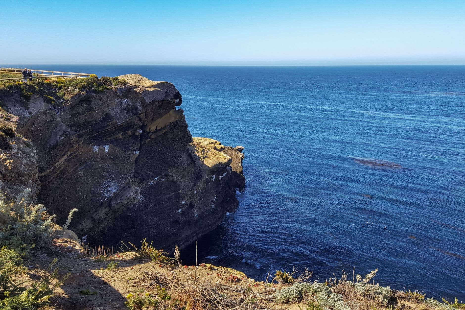
Tomales Point Trail
Photo by dh tang on Pexels
The overlook at mile 1.5 captures both bay and ocean in a single frame โ€” arrive before midday crowds thicken the trail.
Not wheelchair accessible; trail is unpaved with some uneven, exposed sections.
Optional detour: Alamere Falls Trail โ€” After Point Reyes (Chimney Rock) and before Tomales Point Trail
For families with strong hikers wanting a bigger payoff โ€” a rare waterfall that spills directly onto the beach, with wildflowers lining much of the route this time of year. Skip if: At 4+ hours round trip with a steep, sometimes treacherous final descent, it's too long and demanding to pair with Tomales Point in the same day โ€” pick one or the other.
If it rains: Point Reyes' exposed trails become genuinely hazardous in heavy rain โ€” muddy, slippery, and low-visibility. If the forecast turns, stick to short loops near the Point Reyes Visitor Center and skip Tomales Point entirely, saving it for a clearer day.

The drive out to Point Reyes trades forested switchbacks for wide-open ranchland, fog often clinging to the hills before burning off by mid-morning. Chimney Rock delivers an immediate payoff โ€” dramatic cliffs, sea stacks, and often wildlife sightings โ€” without demanding much physical effort, making it a good warm-up before the day's main trail. Arriving early keeps both the parking lot and the overlook blessedly uncrowded.

Tomales Point Trail is where the day earns its adventure credentials โ€” a windswept ridge walk with tule elk grazing in the near distance and two very different bodies of water visible from the same vantage point. Turning back around the mile 1.5 overlook keeps the round trip reasonable for a family pace while still delivering the full sensory payoff: wind, wildlife, and views that make the whole trip feel worth the drive.

With legs tired and cameras full, the drive back toward San Francisco is a good time to decompress and let the day settle โ€” Point Reyes tends to leave a lasting impression precisely because it feels so far removed from the city, wild and unmanicured in a way the rest of the trip only hints at. Wrap the trip with an easy, unhurried dinner back in the city, swapping trail stories and photos from three very different days.

Want to tweak this trip?

Our AI planner can customize this itinerary to your exact dates, interests, and travel style.

Customize This Itinerary
Good to Know

Restaurant details (hours, menus, availability) change frequently. Check current hours before visiting, especially in seasonal destinations.

Dietary compatibility tags are general guidance. If you have severe allergies, confirm directly with the restaurant.

Travel tips are general guidance, not professional safety advice. Check government advisories for latest information.

All prices are approximate and may vary seasonally.
We use cookies to improve your experience and analyze site usage. Essential cookies are always active. You can customize your preferences or accept all cookies. Cookie Policy