3 DaysSolo Traveler6 Stops

Red River Gorge (Slade area), Kentucky

3-Day Itinerary for Solo Traveler

Sandstone Solitude: Three Days Alone with Kentucky's Wild Arches

Sandstone Solitude: Three Days Alone with Kentucky's Wild Arches

The gorge wakes up slow, mist pooling in the hollows while sandstone cliffs catch the first amber light. Here, alone on a ridge line with nothing but birdsong and the distant hush of the Red River, the noise of everywhere else finally drops away.

At a Glance

Climate & Weather
Summer means warm-to-hot days (75–90°F), high humidity, and a real chance of afternoon thunderstorms. Pack moisture-wicking layers, a light rain shell, sun protection, and sturdy trail shoes with grip for sandstone. Start hikes early to beat both heat and storms.
Getting Around
A car is essential — there's no public transit in the Slade area. Trailheads are connected by winding forest roads (KY-15, Nada Tunnel Road, KY-77); expect 15-30 minute drives between clusters. Cell-based GPS can be unreliable, so download offline maps in advance.
Budget
Budget roughly $45-70/day for a solo traveler covering trail snacks, two sit-down meals, and minor gear or permit costs — lodging not included.
Safety
Solo hikers should tell someone their planned route and expected return time — cell coverage is spotty in the gorge's hollows. Watch footing on wet or loose sandstone, especially near cliff edges without railings. Black bears and copperheads are present but rarely encountered; make noise on trails and store food properly. Flash flooding is a real risk after storms, so check forecasts before committing to river-adjacent trails.
Connectivity
Cell signal is thin to nonexistent in the gorge itself, improving near Slade village and Natural Bridge State Park's lodge area. Download maps, trail apps, and any reservations offline before setting out each day.
Local Tips
Arrive at trailheads by 7:30-8am in summer; parking lots at Auxier Ridge and Sky Bridge fill by mid-morning on any day, not just weekends. Pack more water than feels necessary — humidity accelerates dehydration. Solo travelers often find easy conversation at trailhead parking lots and at communal-style local diners, where regulars are used to swapping trail intel with strangers.

Highlights

  • Standing beneath Natural Bridge as morning light pours through the arch
  • Solo scramble to Sky Bridge's underside before the day-trippers arrive
  • Windswept panoramas along Auxier Ridge with nobody in sight
  • Chimney Top Rock's 360-degree canyon views at golden hour
  • Appalachian comfort food after a long day on the trail
  • Early-start strategy that keeps you ahead of summer crowds
  • Quiet, contemplative solo hiking through 100+ natural arches

Day-by-Day Plan

Arrival & Orientation

Day 1: First Light Through the Arch

A gentle introduction to the gorge's most accessible wonders, roughly 3-4 miles of walking at a relaxed pace.

Wear
Breathable hiking layers, moisture-wicking shirt, trail shoes with good grip, sun hat, and a light rain shell for possible afternoon storms.
Budget
$40-55
7:30 AM - 9:30 AM
Natural Bridge SP · morning · 120 min · Natural Bridge & Sky Bridge Loop

Arrive while the gorge still holds its overnight cool and the arch glows pale amber against a waking sky. By 7:30am you'll likely have the viewpoint to yourself — a rare gift at one of the gorge's most photographed spots. Sound carries strangely here: water echoes up from the gorge floor, and the wind tunnels through the arch opening with a low hum that feels almost ceremonial.

Natural Bridge SP
Alfred William Howitt / wikimedia (Public domain)
Shoot from the trail approach in early morning light, when mist often still lingers in the gorge below the arch.
Trail to the main viewpoint involves uneven, sometimes steep sections; not wheelchair accessible.
20 min driveA winding forest road with glimpses of cliff line through the trees — roll the windows down for the cool morning air.
10:15 AM - 11:45 AM
Sky Bridge · midday · 90 min · Natural Bridge & Sky Bridge Loop

A short scramble brings you underneath this 78-foot sandstone span, where cool canyon air rises from the Middle Fork below and the rock face glows rust and amber even in midday light. Standing beneath the arch looking up is disorienting in the best way — scale and stillness compress into one held breath. Crowds start arriving by late morning, so this window still offers relative quiet.

Sky Bridge
Stella Blu / openverse (by)
Get low and shoot up through the arch's underside for the most dramatic perspective; the visitor platform gives the full-span context shot.
Uneven trail terrain; rim viewing area offers a shorter, easier option for those wanting limited walking.
If it rains: If storms roll in, both Natural Bridge and Sky Bridge trails become slippery — consider postponing the Sky Bridge scramble and instead viewing the arch from the accessible overlook areas, or wait out the rain at the Natural Bridge State Park lodge area.

The day begins deliberately slow, easing into the gorge's rhythm rather than rushing it. Natural Bridge rewards the early riser with solitude and soft light — the kind of quiet that makes the whole trip feel like it's finally begun.

After Sky Bridge, the early heat and rising humidity make midday the natural time to retreat toward Slade for lunch and a slower pace, letting the body adjust to the trail conditions before tomorrow's longer push.

Settle into Slade village for the evening — an easy dinner, an early night, and a chance to review tomorrow's route while cell signal is still reliable near the lodge area.

High Ridge Adventure

Day 2: Ridge Line and Wind

The most demanding day of the trip — roughly 5-6 miles of ridge-line hiking with significant elevation change and high energy output.

Wear
Sturdy hiking boots with ankle support, moisture-wicking layers, a hat and sunscreen for exposed ridge sections, and a packable rain shell given summer's afternoon storm risk.
Budget
$35-50
25 min driveForest roads narrow and wind past dense tree cover — a good stretch to mentally shift into hiking mode.
7:00 AM - 7:45 AM
Chimney Top Rock · morning · 45 min · Auxier Ridge & Chimney Top

Arrive as the morning breeze is still cool and sharp, whipping across the bare sandstone cap. The 360-degree view stretches over rust-red cliffs and green canopy in every direction — a fitting overture before the longer ridge hike ahead. Weekday mornings like this one are notably quieter than the weekend crowds that build by midday.

Chimney Top Rock
Bjørn Christian Tørrissen / openverse (by-sa)
Shoot east-facing cliff walls just after sunrise, when the light rakes across the rock and deepens the rust-red tones.
Limited access due to exposed rock and uneven terrain; not suitable for those with mobility restrictions.
10 min walkA short connector trail links the two, the sandstone underfoot still cool from the night.
8:15 AM - 11:15 AM
Auxier Ridge · midday · 180 min · Auxier Ridge & Chimney Top

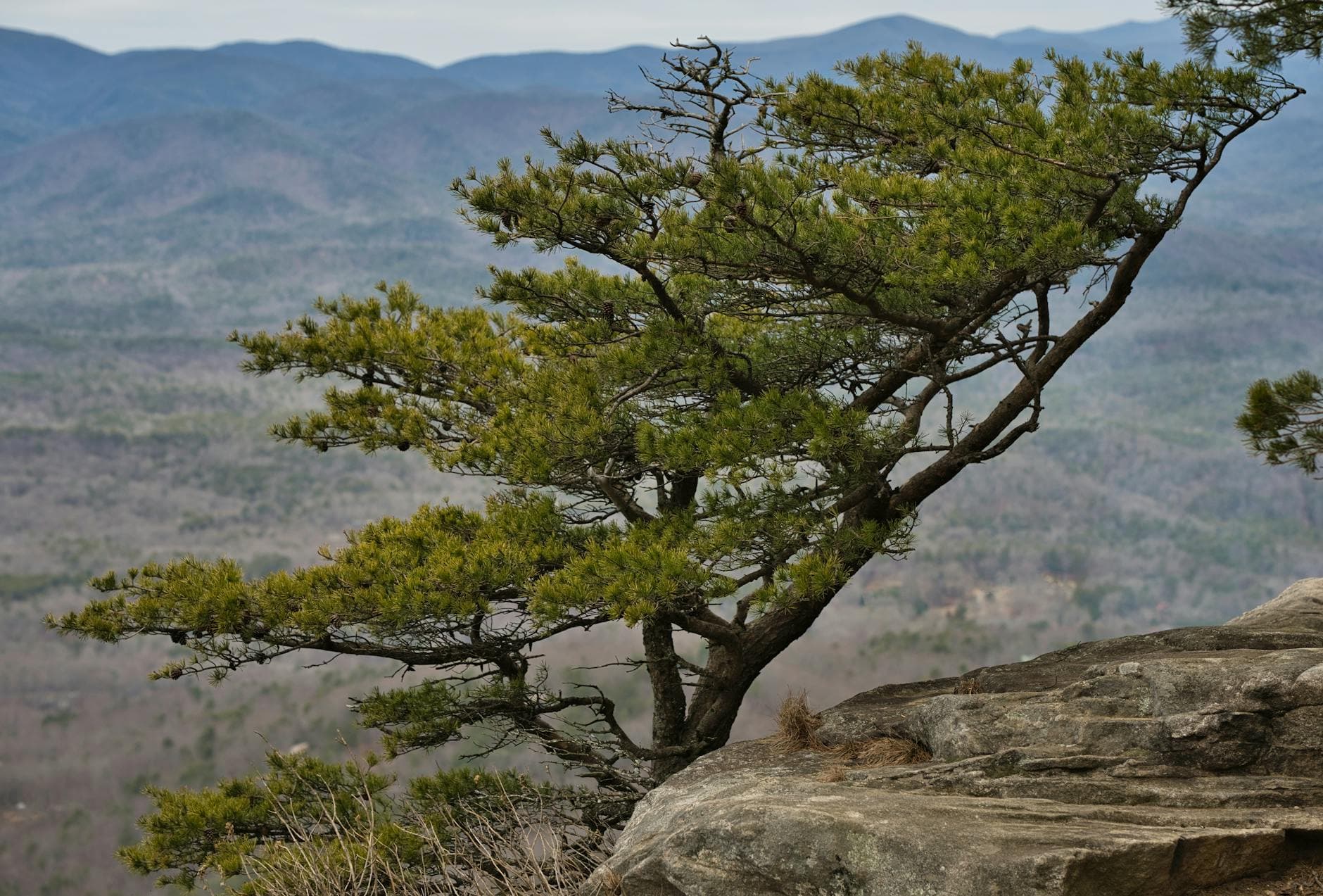
This is the heart of the day — a windswept spine of sandstone where the forest suddenly falls away to reveal layered ridgelines fading into blue haze. Hiking solo here means moving at your own rhythm, pausing as long as you like at each vista, letting silence do most of the talking. It's high-energy terrain, but the payoff is a sense of scale that's hard to describe secondhand.
Auxier Ridge
Thomas K / pexels (Pexels License)
The main ridge overlook facing south is best photographed mid-morning, when light hits the gorge without the harsh glare of midday.
Not recommended for those with mobility limitations — narrow ridge trail with exposed drop-offs.
Optional detour: Chimney Top RockAfter Auxier Ridge and before returning to Slade
A second pass at golden hour offers a completely different light show across the canyon. Skip if: After a long ridge hike, energy may be better spent resting; the morning visit already covers the essential experience.
If it rains: Wet sandstone on both Chimney Top and Auxier Ridge becomes dangerously slippery — if storms threaten, reroute to sheltered, lower-elevation trails near Double Arch or Gray's Arch, or postpone the ridge hike to the following morning if your schedule allows.

The day opens with a brisk climb to Chimney Top, wind cutting across exposed rock as the gorge reveals itself in full daylight for the first time. It's a short stop, but it sets the tone — remote, elevated, and entirely worth the early wake-up.

Auxier Ridge unfolds slowly through late morning into early afternoon, each vista point offering a reason to linger. By the time the ridge trail loops back, the humidity has usually built enough to make the return hike feel like a proper workout — a natural cue to head back toward Slade before afternoon thunderstorms typical of summer roll through.

Aching legs and dusty boots make for an easy excuse to find a hearty meal in Slade tonight — the kind of comfort food that pairs well with trading trail stories with fellow hikers at a shared table.

Reflection & Departure

Day 3: Slow Mornings and Last Views

A lighter final day revisiting favorite terrain at a relaxed pace, roughly 2-3 miles total, allowing time for reflection before departure.

Wear
Comfortable layers, trail shoes, and a light jacket for cooler early morning air; pack a rain shell just in case.
Budget
$25-40
7:30 AM - 9:00 AM
Natural Bridge SP · morning · 90 min · Natural Bridge & Sky Bridge Loop

One more early visit, this time slower and more contemplative — no rush to capture the perfect shot, just time to sit with the view and let the trip settle in. The gorge feels different on a return visit, familiar in a way that invites quiet reflection rather than discovery.

Natural Bridge SP
Alfred William Howitt / wikimedia (Public domain)
If skies are clear, the sunrise light through the arch is softer and warmer on a return visit than the first morning — worth one more frame.
Trail remains uneven and steep in sections; approach at a relaxed pace.
20 min driveThe same forest road as before, though it feels different now — familiar curves, a quieter kind of goodbye.
9:45 AM - 10:45 AM
Sky Bridge · midday · 60 min · Natural Bridge & Sky Bridge Loop

A shorter final visit — enough time to stand once more beneath the arch, listen to the river below, and take in the scale of the place before heading toward departure. This lighter pace matches the winding-down mood of a last day.

Sky Bridge
Stella Blu / openverse (by)
Late morning light on the visitor platform captures the full arch span with fewer shadows than earlier hours.
Rim viewing area offers a shorter option if energy is limited on the final day.
Optional detour: Chimney Top RockAfter Sky Bridge and before departure
A final panoramic view offers a strong closing moment if time and energy allow before driving out. Skip if: If departure timing is tight, this adds roughly 45 minutes plus drive time that may be better spent getting ahead of traffic.
If it rains: If rain moves in on the final morning, skip the Sky Bridge scramble and instead take a slower loop through Natural Bridge State Park's more sheltered, lower-grade paths near the lodge area.

The final morning moves gently — one last visit to Natural Bridge with no urgency, just the quiet satisfaction of familiar ground. The light through the arch feels like a proper send-off.

A short stop at Sky Bridge rounds out the trip before the drive out of the gorge begins, the pace intentionally unhurried to let the last impressions of sandstone and forest settle in before returning to the wider world.

Departure typically falls in the early afternoon, leaving time for a final easy meal in Slade or Stanton before the drive back toward the airport — a last taste of Appalachian comfort food to close out the trip.

Want to tweak this trip?

Our AI planner can customize this itinerary to your exact dates, interests, and travel style.

Customize This Itinerary
Good to Know

Restaurant details (hours, menus, availability) change frequently. Check current hours before visiting, especially in seasonal destinations.

Dietary compatibility tags are general guidance. If you have severe allergies, confirm directly with the restaurant.

Travel tips are general guidance, not professional safety advice. Check government advisories for latest information.

All prices are approximate and may vary seasonally.
We use cookies to improve your experience and analyze site usage. Essential cookies are always active. You can customize your preferences or accept all cookies. Cookie Policy