3 DaysSolo Traveler5 Stops

Red River Gorge (Slade area), Kentucky

3-Day Itinerary for Solo Traveler

Stone Arches & Solitude: 3 Winter Days in the Red River Gorge

Stone Arches & Solitude: 3 Winter Days in the Red River Gorge

In winter, the gorge empties out and goes quiet — bare sandstone catches low light instead of leaf canopy, and the trails you'd normally share with fifty people belong to you alone. This is a solo traveler's season here: crisp air, sharp views stripped of summer haze, and the particular satisfaction of standing on a windswept ridge with no one else in sight.

At a Glance

Climate & Weather
Winter days run cold — expect 25-45°F, biting wind on exposed ridgelines, and the real possibility of ice on rock surfaces even without much snowfall. Pack layers: a moisture-wicking base, insulated mid-layer, waterproof/windproof shell, wool socks, and trail boots with real tread. Days are short — plan to be off exposed terrain well before dusk, which arrives by 5:30 PM.
Getting Around
A car is essential — there's no public transit in the gorge. Roads like KY-15 and US-60 can develop icy patches in winter mornings, especially in shaded curves; drive slowly and allow extra time between clusters.
Budget
Budget roughly $50-75/day for a solo traveler covering meals and any park fees — dining here leans casual and affordable, and most trails are free to hike.
Safety
Solo hikers should tell someone their route and expected return time, carry a charged phone (though signal is patchy), and treat any wet or shaded rock as ice until proven otherwise. Flash flooding is less likely in winter but stream crossings can ice over. Bears are dormant this season, but stay alert regardless and avoid hiking after dark without a headlamp.
Connectivity
Cell service is spotty to nonexistent on trails and in the gorge itself; download offline maps beforehand. Lodging in Slade and Stanton typically has WiFi, but don't count on connectivity once you're on ridge trails.
Local Tips
Winter weekdays mean near-total solitude on trails that are packed in October — arrive at sunrise for light with zero foot traffic. Many small eateries keep shorter winter hours, so confirm before driving out. Layer for wind, not just cold — ridge exposure makes it feel 10-15 degrees colder than the forecast.

Highlights

  • Sky Bridge's 78-foot arch glowing amber in low winter light
  • Sunrise solitude atop Natural Bridge with the gorge to yourself
  • The wind-scoured spine of Auxier Ridge in near-total silence
  • Chimney Top Rock's 360-degree view stripped bare by winter light
  • Hearty Appalachian comfort food after cold-weather hiking
  • Quiet, safe solo hiking with minimal crowds
  • Farm-to-table and diner fare in Slade and Stanton

Day-by-Day Plan

Orientation & easy wonder

Day 1: Arrival and the Bridge of Amber Light

A gentle first day easing into the gorge with roughly 2-3 miles of moderate walking around the Natural Bridge & Sky Bridge Loop.

Wear
Insulated waterproof boots, wool socks, base layer plus fleece, windproof shell, gloves and a warm hat — winter wind cuts sharply on open overlooks.
Budget
$45-60 (meals, no major fees)
9:00 AM - 11:00 AM
Natural Bridge SP · morning · 120 min · Natural Bridge & Sky Bridge Loop

After a long drive in, this is the gentlest possible introduction — a well-trodden trail leading to a sandstone arch that frames a thousand-foot gorge view. Arrive by 9 AM and the cold keeps most visitors away; you'll likely have the overlook to yourself, just wind moving through the arch opening and pale winter light on damp rock. Take it slow — this is about settling into the place, not conquering it.

Natural Bridge SP
Alfred William Howitt / wikimedia (Public domain)
Late morning light comes in low and warm through the arch opening — good contrast against the gorge's grey winter palette.
Trail is uneven and unpaved in sections; sturdy footwear is essential, especially with possible ice.
20 min driveA winding forest road with occasional gorge glimpses through bare branches — go slow on shaded curves that may hold ice.
12:00 PM - 1:30 PM
Sky Bridge · midday · 90 min · Natural Bridge & Sky Bridge Loop

A short scenic drive brings you to a different arch entirely — Sky Bridge's 78-foot span feels more dramatic, more remote, cut into towering canyon walls. Winter strips the trees bare, opening up views into the gorge that summer foliage normally hides. The trail is quiet enough that you can hear the Middle Fork rushing far below.

Sky Bridge
Stella Blu / openverse (by)
Shoot from beneath the arch looking up for the most dramatic perspective — best light is midday when the sun clears the canyon walls.
Uneven trail with some rock scrambling near the arch; not wheelchair accessible.
If it rains: If ice or heavy rain makes trails unsafe, the historic lodge at Natural Bridge State Park offers a warm, covered space to wait out weather and reset plans for the following day.

Ease into the gorge slowly. Natural Bridge's trail is forgiving and well-marked, and the cold keeps the usual crowds thin — a good first taste of the region's scale without overwhelming a travel-weary body. Take breaks, breathe the cold air, and let the arch reveal itself gradually as you approach.

A short, scenic drive delivers you to Sky Bridge, where the terrain feels a touch wilder and the views open dramatically once you're beneath the arch. This is still moderate effort — a good second stop that builds confidence without exhausting you on day one.

With dining options near these trailheads limited this time of year, plan to head into Slade or Stanton for a proper dinner rather than expecting food at the trailhead itself — pack a snack for the drive just in case. Settle in early; tomorrow's ridge hike calls for rested legs.

High effort & solitude

Day 2: Ridge Line, Wind, and Wide Kentucky Sky

The most demanding day — roughly 5-6 miles across Auxier Ridge and Chimney Top Rock, with sustained ridge exposure and high energy output.

Wear
Full winter layering system: base layer, insulating mid-layer, windproof/waterproof shell, gloves, hat, and gaiters if snow is present — ridge wind will be the defining discomfort of the day.
Budget
$40-55 (meals only)
25 min driveA quiet backroad drive westward, mist still clinging to the hollows in the early morning cold.
8:00 AM - 8:45 AM
Chimney Top Rock · morning · 45 min · Auxier Ridge & Chimney Top

Start here at first light — arrive by 8 AM and the weathered rock cap is entirely yours, wind whipping around bare stone as the sun catches rust-red cliffs across the canyon. It's a short, sharp payoff: minimal effort for a 360-degree view that sets the tone for the bigger hike ahead.

Chimney Top Rock
Bjørn Christian Tørrissen / openverse (by-sa)
Shoot east into the rising sun for cliffs lit gold — get there before 8:30 AM before the light flattens out.
Rock scrambling required near the summit; not suitable for limited mobility.
15 min walkA connector trail through quiet forest, the transition from summit views to ridge walking.
9:15 AM - 12:15 PM
Auxier Ridge · midday · 180 min · Auxier Ridge & Chimney Top

This is the centerpiece of the trip — a windswept spine of trail with sudden, breath-catching vistas where the forest simply drops away. In winter, without leaf cover, the views stretch further and the solitude runs deeper; you may not see another hiker for hours. Take it at a careful, deliberate pace on the exposed sections, and budget real time for the overlooks — this is where the gorge shows its full scale.
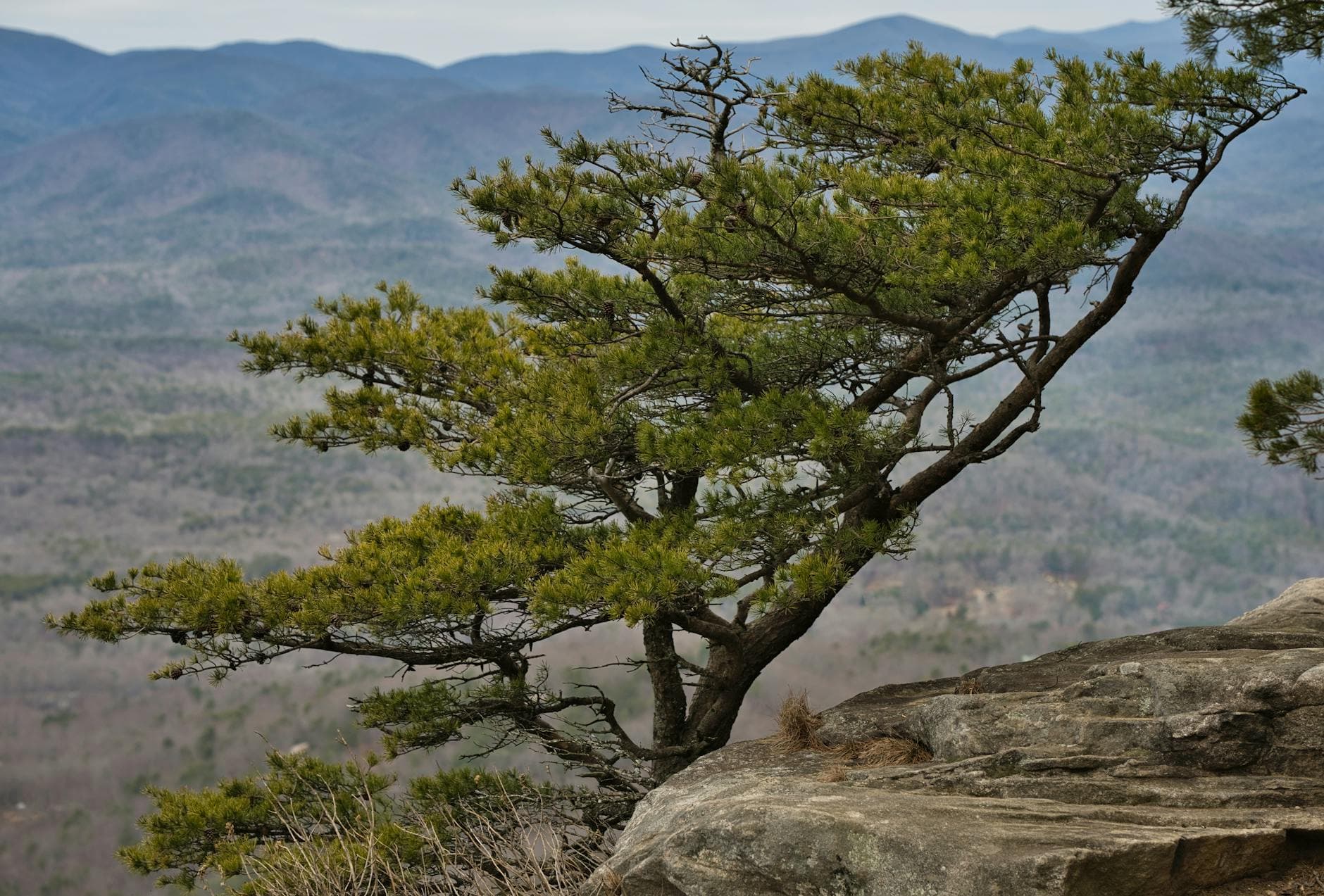
Auxier Ridge
Thomas K / pexels (Pexels License)
The main ridge overlook facing south is best around midday when the winter sun is highest and shadows are shortest across the gorge.
Strenuous, exposed terrain with narrow sections — not recommended for anyone with mobility concerns, and solo hikers should watch footing closely on any icy patches.
Optional detour: Double ArchAfter Auxier Ridge and before returning to lodging
A worthwhile shelter-adjacent detour if energy and daylight remain, offering a quieter arch away from the ridge crowds. Skip if: Skip if daylight is fading or legs are spent — winter's short days don't forgive lingering, and the ridge itself was already the day's main reward.
If it rains: If rock turns icy or rain moves in, retreat to Natural Bridge State Park's paved and covered viewing areas from yesterday's cluster rather than risking exposed ridge terrain.

Begin in the dark-edged cold of early morning, climbing quickly to Chimney Top Rock for a short, rewarding payoff before the sun is fully up. The rock cap is bracing and open — a good warm-up for the bigger effort ahead on Auxier Ridge.

The ridge hike is the physical and emotional peak of the trip: sustained exposure, big views, and a kind of solitude that's rare to find in a place this scenic. Move deliberately on narrow or icy sections, and let the overlooks slow you down — there's no rush when the trail is this empty.

With no dining data near the trailhead, plan your evening meal back in Slade or Stanton rather than expecting anything at the ridge itself. After a demanding day, an early dinner and an early bedtime will serve you far better than pushing into the evening.

Wind-down & reflection

Day 3: Slow Farewell to the Arches

A lighter closing day revisiting the Natural Bridge & Sky Bridge Loop at a slower pace, roughly 2 miles total, before departure.

Wear
Similar winter layering to Day 1, though slightly less technical — sturdy boots, warm layers, and gloves for a relaxed final outing.
Budget
$35-50 (meals only)
8:30 AM - 10:00 AM
Natural Bridge SP · morning · 90 min · Natural Bridge & Sky Bridge Loop

Return to the bridge one more time, but slower — this visit is about closure, not discovery. Arrive early enough to catch the last of the morning mist rising through the arch, and take the extra time you skipped on day one to sit, breathe, and notice details missed the first pass.

Natural Bridge SP
Alfred William Howitt / wikimedia (Public domain)
Early morning mist rising through the arch is a distinct shot from the golden-hour version you may have caught on Day 1 — come before 9 AM for the best chance of fog.
Same uneven, unpaved trail conditions as before — watch for lingering ice in shaded patches.
Optional detour: Sky BridgeAfter Natural Bridge SP and before departure
A calmer, shorter return visit if you have extra time before hitting the road and want one more look at the arch in different light. Skip if: Skip if you're pressed for departure time — you've already experienced this stop fully on Day 1, and the marginal value is lower on a travel day.
If it rains: If conditions are poor, spend the remaining time at the historic lodge area, warm and covered, before making the drive out.

Close the trip gently with one more slow pass through Natural Bridge, this time without the urgency of a first visit — just quiet observation, mist in the gorge, and a last look at the arch that opened the trip three days ago.

With the main hiking behind you, afternoon is really about logistics — packing up, settling into the drive out, and perhaps a last coffee or meal in Slade or Stanton before hitting the road.

Depending on departure timing, evening may simply be travel — but if there's a window, a final unhurried meal in town is a fitting, low-key send-off from a trip built on solitude and quiet stone.

Want to tweak this trip?

Our AI planner can customize this itinerary to your exact dates, interests, and travel style.

Customize This Itinerary
Good to Know

Restaurant details (hours, menus, availability) change frequently, especially in winter when small-town establishments may reduce hours. Check current hours before visiting.

Dietary compatibility tags are general guidance. If you have severe allergies, confirm directly with the restaurant.

Travel tips are general guidance, not professional safety advice. Check current trail and road conditions before heading out, especially in icy winter weather.

All prices are approximate and may vary seasonally.
We use cookies to improve your experience and analyze site usage. Essential cookies are always active. You can customize your preferences or accept all cookies. Cookie Policy