Driftless Area (Southwest), Wisconsin
2-Day Itinerary for Solo Traveler
“Limestone Silence: Two Winter Days in the Driftless”
In winter, the Driftless Area empties out into something rarer than its summer self — bluffs rimed in frost, trails you'll have entirely to yourself, and a stillness that makes the region's ancient, glacier-spared geology feel even older. This is a trip for solo travelers who want their landscapes uncrowded and their evenings spent at a tavern bar where the bartender remembers regulars by name.
At a Glance
Highlights
- Sunrise-quiet trails at Governor Dodge with nobody else on the bluff rim
- A 50-degree underground world at Cave of the Mounds, immune to winter entirely
- Frost-rimmed cliffs along the Kickapoo River with zero summer crowds
- Small-town Dodgeville taverns where solo diners pull up a stool and talk to strangers
- Golden hour on limestone bluffs turning pink over snow-dusted valleys
- Genuine off-season solitude in a region built for slow, deliberate travel
Day-by-Day Plan
Day 1: Settling Into Stone and Silence
A gentle first day mixing an easy, well-groomed park walk with a fully indoor cave tour — about 2 miles of walking total, low-to-moderate energy, ideal for easing into the region's rhythms.
Arrive right after sunrise and the park belongs to you — snow-quiet trails, limestone cliffs catching the first pale light, and maybe a pileated woodpecker's knock echoing off frozen bluffs. Winter strips the crowds entirely; where summer brings hikers shoulder to shoulder by 10am, a January weekday morning here is just you, the cold air, and the crunch of packed snow underfoot. Stick to the lower loop trails near Cox Hollow Lake, which stay more manageable in ice and snow than the steeper bluff routes.

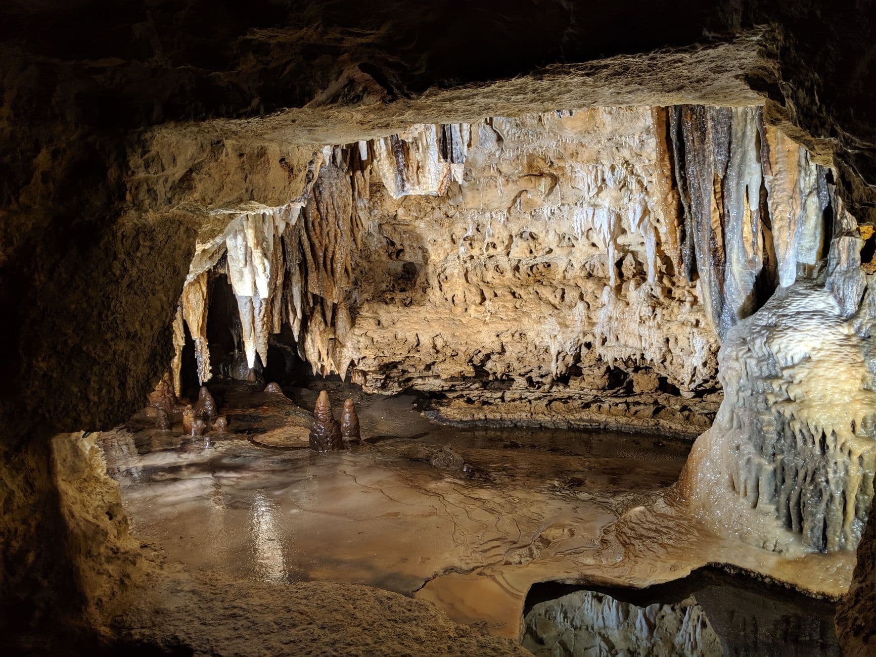
Descend from the cold into a constant 50 degrees, where calcite crystals glint under soft lighting and your footsteps echo off stone corridors untouched by season. This is the perfect winter counterpoint to a frosty morning outside — no weather to fight, no crowds to navigate, just quiet mineral chambers and a still black reflection pool that mirrors the formations above it perfectly. Solo travelers often find cave tours a natural place to chat with the small guided group, since everyone's marveling at the same crystal ceiling.
The day begins slow and quiet, easing you into the Driftless rhythm with a short walk at Governor Dodge State Park. Snow muffles the trail sounds, cold air sharpens the smell of pine, and the lake sits still and half-frozen below limestone cliffs. This isn't a full hiking day — just enough movement to get your bearings and feel the scale of this glacier-spared landscape before heading somewhere warmer.
From the cold, open bluffs you'll drop underground at Cave of the Mounds, trading frost for a steady 50-degree world of crystal formations and still water. It's a deliberate contrast — outdoor cold followed by indoor stillness — and a good rhythm for a first day when you're still finding your pace. The tour groups here tend to be small in winter, making it easy to strike up conversation with fellow visitors.
Head into Dodgeville as the light fades early — winter sunsets here arrive by late afternoon — and settle into one of the town's local taverns for a hearty dinner. Bar seating is the move for solo travelers: pull up a stool, order something warm and Midwestern, and let the evening unwind slowly, the way locals do it here, often wrapping up by 8pm.
Day 2: River Ghosts and Confluence Light
A full day tracing the Kickapoo River valley before finishing at the dramatic Mississippi-Wisconsin confluence at Wyalusing — roughly 3 miles of walking across two outdoor clusters, moderate energy with real cold-weather exposure.
In summer this valley fills with kayakers and tubers; in winter it's a hushed, rust-and-white world of ice-fringed banks and towering cliffs rising abruptly from snow-dusted forest. Arrive early and you may have the bridge overlooks entirely to yourself, watching mist curl off any open water while a bald eagle works the thermals overhead. This is prime solitude territory — bundle up, walk the accessible overlooks near the boat launches, and let the quiet do the work.
By afternoon the light turns long and gold over the confluence of the Mississippi and Wisconsin Rivers, visible from 500-foot bluffs that feel almost otherworldly in their winter silence — no summer crowds, no boat traffic, just two vast rivers meeting far below and ancient effigy mounds resting under snow. Winter visitation here drops to nearly nothing between November and March, meaning solo travelers get the rare gift of a major overlook entirely to themselves. Budget real time at Tower Hill for sunset, since this is one of the region's defining views.

The morning belongs to the Kickapoo — a slow drive into bohemian river-valley towns followed by a quiet walk along ice-edged banks beneath towering cliffs. Winter has emptied this valley of its usual paddlers and tubers, leaving just the sound of wind through bare branches and maybe an eagle's cry overhead. It's contemplative, unhurried, and a good reminder of how differently this landscape reads without summer's crowds.
The drive south toward Wyalusing trades intimate river corridor for sweeping scale, culminating in bluff-top views over the meeting point of two major rivers. Afternoon light softens gradually into gold, and with almost no winter visitors on the trails, the overlooks feel like a private discovery rather than a tourist stop. This is the day's physical and emotional high point — worth lingering through sunset if the cold allows.
With the light gone early, head into Prairie du Chien for dinner and a slower wind-down — a fitting close to a trip built around solitude and geological drama. Solo travelers will find the town's local dining scene welcoming to a single diner at the bar, and an early night suits the region's rhythm, where most restaurants and the day itself wrap up well before 9pm.
Want to tweak this trip?
Our AI planner can customize this itinerary to your exact dates, interests, and travel style.
Customize This ItineraryRestaurant details (hours, menus, availability) change frequently, and specific dining recommendations were limited for these POIs — always check current hours before visiting, especially in a rural winter destination where some spots close seasonally or on Mondays.
Dietary compatibility tags are general guidance. If you have severe allergies, confirm directly with the restaurant.
Travel tips are general guidance, not professional safety advice. Check road condition reports and government advisories for the latest winter driving information.
All prices are approximate and may vary seasonally.