2 DaysTeen Families7 Stops

San Francisco Bay Area (day trips), California

2-Day Itinerary for Teen Families

“Redwoods, Ridgelines & Rocky Shores: A Bay Area Weekend for Teens and Parents Alike”
Redwoods, Ridgelines & Rocky Shores: A Bay Area Weekend for Teens and Parents Alike

Fog curls through two-thousand-year-old redwoods while, an hour south, waves crash against pumpkin-dotted bluffs — this is the Bay Area's day-trip magic, where cathedral groves and wind-scoured ridgelines sit improbably close to the city. Fall strips away the summer crowds and softens the light, leaving trails quieter and golden hour earlier. This weekend is built for families navigating the tricky middle ground between a teen's need for independence and a parent's need for a good view.

At a Glance

Climate & Weather
Fall brings cooling temperatures (50s–60s°F), thinning fog, and some of the year's clearest hiking weather, though mornings stay damp and chilly. Pack layers — a warm base layer, a waterproof windbreaker, and sturdy closed-toe shoes are non-negotiable for both redwood groves and coastal bluffs.
Getting Around
A rental car is essential — these are all drive-to destinations with no meaningful transit link. Expect 30–90 minute drives between clusters, and budget extra time for parking at popular trailheads, which fill by mid-morning on clear days.
Budget
Plan roughly $90–140 per day per family of four for meals and incidentals; Muir Woods requires a timed-entry reservation (~$9–15/person) and parking fees apply at most trailheads.
Safety
Coastal cliffs and bluff-top trails have real drop-offs; keep teens on marked paths, especially at Point Reyes and Pescadero. Fog can roll in fast and cut visibility on headland roads, so drive cautiously and don't rush sunset photo stops.
Connectivity
Cell coverage is spotty to nonexistent in Muir Woods, on Mount Tam's back trails, and along stretches of coastal Highway 1 — download offline maps before leaving the city. Wi-Fi is reliable in town centers like Half Moon Bay and Mill Valley.
Local Tips
Arrive at Muir Woods and Mount Tamalpais before 9am — both fill parking and permit slots quickly even in the quieter fall season. Half Moon Bay's pumpkin season (through late October) means weekend crowds downtown, so aim for a weekday or early arrival. Give teens 20–30 minutes of unstructured time at beaches or town centers — it noticeably improves group mood for the rest of the day.

Highlights

  • Stand beneath 2,000-year-old redwoods on the accessible Redwood Creek Trail Loop
  • Catch sunrise solitude at Mount Tamalpais before the parking lot fills
  • Walk Stinson Beach's tide pools and let teens explore the rocky outcrops solo
  • Wander Half Moon Bay's fog-laced Main Street and harbor at golden hour
  • Hunt tide pools and watch for migrating whales at Pescadero State Beach
  • Photograph California's tallest lighthouse at Pigeon Point
  • Eat sushi, pizza, or Thai — something for every picky or adventurous teen palate

Day-by-Day Plan

Forest and summit

Day 1: Redwood Hush and Ridgeline Light

A gentle-to-moderate day covering roughly 3 miles of walking, easing the group into the trip with a flat redwood loop before a short climb for sweeping Bay views and a late-afternoon beach wind-down.

Wear
Layered clothing — a warm base layer under a waterproof jacket, long pants, and sturdy sneakers or light hiking shoes; bring a hat for Mount Tam's wind.
Budget
$110–150 for a family of four, including Muir Woods entry/parking, lunch, and dinner
8:00 AM - 9:30 AM
Muir Woods (early reservation) · morning · 90 min · Muir Woods & Mill Valley

Book the earliest reservation slot you can get — by 8am the grove still holds its overnight hush, fog threading between trunks wide enough to hide a car. The 2,000-year-old redwoods don't need a hard sell to teens; the scale alone does the work, and the cool, earthy air feels like stepping into another century. Peak crowds hit 10am–2pm, so this early window is the difference between quiet reverence and shoulder-to-shoulder shuffling.

Muir Woods (early reservation)
Ontario. Royal Commission on Forest Reservation and National Park / wikimedia (Public domain)
The twin redwoods near the entrance photograph best in the soft, diffused light of early morning before direct sun breaks through the canopy.
Main boardwalk sections are accessible, but side trails have roots and uneven footing.
5 min walk — A short walk deeper into the grove, the crowd thinning as the main trail splits off.
9:30 AM - 10:30 AM
Redwood Creek Trail Loop (Muir Woods Extension) · morning · 60 min · Muir Woods & Mill Valley

This flat, well-benched extension loop lets the family spread out a little — older kids can range ahead to the creek crossings while parents linger at Cathedral Grove, the densest, most photogenic cluster of ancient trees on the whole route. The creek's gentle murmur and frequent benches make this the easiest stretch of the day, a good warm-up before the climb ahead.
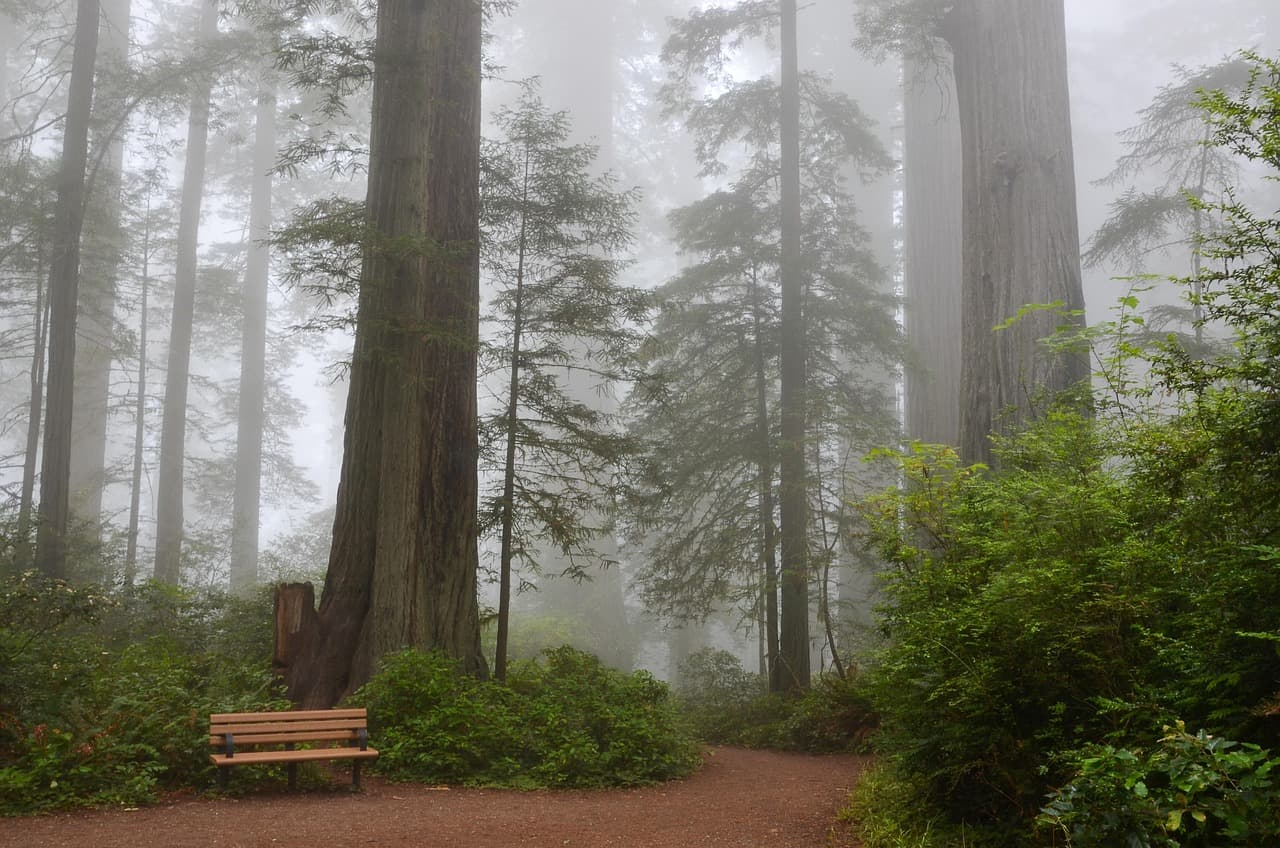
Redwood Creek Trail Loop (Muir Woods Extension)
Photo by USA-Reiseblogger on Pixabay
The main bridge over Redwood Creek offers the classic reflected-tree shot — best around 10am as light starts filtering through the canopy.
Flat path with benches roughly every 200 meters, the most wheelchair-friendly stretch of the cluster.
25 min drive — A winding ascent through Mill Valley's eucalyptus-lined streets before the road climbs into open ridgeline.
11:15 AM - 1:30 PM
Mount Tamalpais · midday · 135 min · Marin Headlands & Mount Tamalpais

The drive up delivers switchback after switchback until the trees fall away and the whole Bay unfurls below — on a clear fall day, visibility stretches to the Sierra Nevada. Stick to the shorter loop trails near Pantoll Ranger Station rather than a full summit push; teens get a real sense of achievement from the East Peak lookout without the group running out of steam. Midday brings more visitors than dawn, but fall's thinner crowds keep it manageable.

Mount Tamalpais
Banks, Charles Eugene, 1852-1932 Read, Opie Percival, 1852-1939 / wikimedia (Public domain)
The Pantoll Ranger Station overlook catches dramatic light in early afternoon, with fog banks sometimes visible rolling over the ridgelines below.
Paved overlooks near the main parking area are accessible; the summit loop trails are not.
20 min drive — A descent down Panoramic Highway with ocean glimpses breaking through the trees at every curve.
2:30 PM - 4:30 PM
Stinson Beach · afternoon · 120 min · Marin Headlands & Mount Tamalpais

After the ridgeline's wind and elevation, the beach feels like a reward — wide, sandy, and easy, with a rocky outcrop near the lifeguard tower that's tide-pool gold for curious teens. Give them 30 minutes to wander the rocks alone while parents claim a spot on the sand; the Pacific swells here are genuinely impressive, a good contrast to the morning's forest hush. Fall afternoons stay mild enough for bare feet in the sand, even if the water's too cold for swimming.
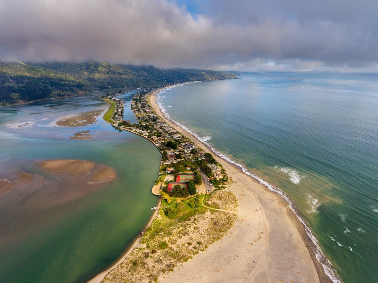
Stinson Beach
Photo by derwiki on Pixabay
The southern end of the beach looking north toward the bluffs is best around 4pm, as the light turns warm and low.
Flat, wheelchair-accessible sand path near the main entrance; tide pool rocks require careful footing.
Optional detour: Stinson Beach — After Mount Tamalpais and as the day's closing stop
Offers a low-key, flat-terrain finish after a morning of forest and ridgeline walking, with built-in teen autonomy at the tide pools. Skip if: Skip if the group is running late or fog has rolled in thick, since the beach loses its appeal without visibility or sun.
If it rains: If rain moves in, shift the day toward Muir Woods and Sausalito's waterfront — the redwoods are atmospheric in light rain, and Sausalito's galleries and covered walkways offer a dry pivot from the exposed, slippery trails of Mount Tam.

The day opens in near-silence, redwood fog settling over an empty boardwalk as the family's early reservation beats the crowds by a full two hours. The Redwood Creek Trail Loop extends that calm, its flat, bench-lined path giving everyone room to roam at their own pace along the creek before the climb ahead.

The pace shifts dramatically at Mount Tamalpais, where a winding drive trades forest shade for open ridgeline and wind — the Bay spreads out below in a view that earns every switchback. From there, the group drops back down to sea level at Stinson Beach, swapping summit wind for sand underfoot and a slower, more social rhythm.

Dinner options should be planned in town rather than at the beach itself, since no mapped dining data exists for this cluster — Mill Valley's main strip, a short drive back toward the highway, is the practical choice for a relaxed first-night meal before the family settles in for the night.

Coastal village and cliffs

Day 2: Fog, Pumpkins, and the Edge of the Continent

A moderate day of roughly 3.5 miles total walking across three coastal stops, balancing small-town wandering with dramatic bluff-top scenery and a lighthouse finale before sunset.

Wear
Windproof layers, a warm hat, and closed-toe shoes with grip for uneven cliff paths; sunglasses for the exposed coastal light.
Budget
$100–140 for a family of four, including lunch, snacks, and minor shopping along Main Street
55 min drive — A coastal highway drive south, Highway 1 tracing cliffs with ocean flashing into view at every rise.
9:00 AM - 11:30 AM
Half Moon Bay · morning · 150 min · Half Moon Bay & Coastal Bluffs

Arrive before 9:30am and Main Street still belongs to locals — fishing boats bob quietly in Pillar Point Harbor while fog hangs low over the crescent shoreline. Fall means pumpkin season is winding down but still visible in farm-stand displays, and teens get real freedom here, browsing shops solo while parents linger over coffee. By late morning the town fills with weekend visitors, so this early window is worth protecting.

Half Moon Bay
Elliot, G. F. Scott (George Francis Scott), 1862-1934 / wikimedia (Public domain)
The harbor overlook catches fishing boats silhouetted against fog in soft morning light — return at sunset for the same view in gold.
Main Street and harbor walk are flat and wheelchair-accessible with frequent benches.
15 min drive — A short hop further down Highway 1, farm stands and artichoke fields rolling past the windows.
12:15 PM - 2:00 PM
Pescadero State Beach & Marsh Natural Preserve · midday · 105 min · Half Moon Bay & Coastal Bluffs

The sandstone cliffs here feel wilder and less manicured than Half Moon Bay's town beach — cormorants wheel overhead while the marsh's boardwalks offer a quieter counterpoint to the pounding surf on the sand side. Fall is whale migration season, so scan the horizon; teens with binoculars or a good phone zoom have a real shot at a sighting. Keep everyone back from the cliff edges, which drop off more sharply than they appear.

Pescadero State Beach & Marsh Natural Preserve
Photo by Edwardo Calles on Pexels
The main beach overlook frames sandstone cliffs against the ocean best in early afternoon light, before the fog thickens.
Uneven, unpaved terrain throughout; not suited to wheelchairs or strollers.
10 min drive — A quick coastal hop, the lighthouse visible from the road well before the turnoff.
2:45 PM - 4:15 PM
Pigeon Point Lighthouse · afternoon · 90 min · Half Moon Bay & Coastal Bluffs

California's tallest lighthouse rises stark and striped against the sky, waves hammering the rocks below in a rhythm that's almost hypnotic. This is the trip's best photo opportunity — cypress trees frame the tower from the north overlook, and tide pools at the base reward a slow, careful look. With fall's shorter days, this timing catches the light turning gold without pushing dinner too late.

Pigeon Point Lighthouse
Photo by Olzheim on Pixabay
The keeper's house and red tower catch a striking reflection at golden hour, roughly 4pm in fall.
Trails are uneven and not wheelchair accessible; the viewing area near the parking lot offers a decent vantage for those with mobility limits.
Lunch
Sushi Main Street $$
japanese · Near Half Moon Bay
A trendy, teen-approved option with fresh rolls and a lively atmosphere right on Half Moon Bay's main strip.
Thai Cuisine $$
thai · Near Half Moon Bay
Flavorful, varied menu that's easy on picky eaters and adventurous ones alike.
Dinner
The Flying Fish Grill $$
seafood · Near Half Moon Bay
Fresh, no-frills seafood that captures the coastal day's spirit without the markup of a fancier harbor spot.
Straw Hat Pizza $
pizza · Near Half Moon Bay
A reliable, casual crowd-pleaser if teens are craving something familiar after a day of cliffs and wind.
Optional detour: Point Reyes (Chimney Rock, Tomales Point) — Could replace Pescadero State Beach if the family prefers a longer, wilder detour
Offers dramatic sea-cliff views and a real chance to spot tule elk, a bigger payoff for families craving more adventure. Skip if: Adds significant drive time (over an hour each way from Half Moon Bay) that would compress the rest of the day's plans.
If it rains: If rain sets in, pivot to Half Moon Bay's indoor galleries and covered Main Street shops, or drive to Pescadero's small village center — the cliffs and lighthouse trails become slippery and visibility drops too much for safe bluff walking.

Half Moon Bay greets the family in fog and quiet, fishing boats barely visible in the harbor as the town wakes up slowly around them. Teens peel off to browse shops while parents settle into a harborside coffee, the whole morning moving at an unhurried, small-town pace.

The mood shifts toward wilder terrain at Pescadero, where sandstone cliffs and marsh boardwalks replace Main Street's storefronts, and the group scans the horizon for migrating whales between bites of a packed lunch. From there, it's a short drive to Pigeon Point, where the lighthouse's striped tower and pounding surf provide the day's most dramatic backdrop.

Dinner lands back in Half Moon Bay, where the choice between fresh seafood at The Flying Fish Grill and the easy comfort of Straw Hat Pizza lets the group end the weekend exactly how they'd like — fog settling back over the harbor as the lights of Main Street flicker on.

Want to tweak this trip?

Our AI planner can customize this itinerary to your exact dates, interests, and travel style.

Customize This Itinerary
Good to Know

Restaurant details (hours, menus, availability) change frequently. Check current hours before visiting, especially in seasonal destinations.

Dietary compatibility tags are general guidance. If you have severe allergies, confirm directly with the restaurant.

Travel tips are general guidance, not professional safety advice. Check government advisories for latest information.

All prices are approximate and may vary seasonally.
We use cookies to improve your experience and analyze site usage. Essential cookies are always active. You can customize your preferences or accept all cookies. Cookie Policy