2 DaysSolo Traveler5 Stops

Rocky Mountain NP (Trail Ridge Road), Colorado

2-Day Itinerary for Solo Traveler

Tundra Light and Alpine Water: 2 Days on Trail Ridge Road

Tundra Light and Alpine Water: 2 Days on Trail Ridge Road

The road climbs until the trees give up and the sky takes over — tundra rolling gold-green under wind that never quite stops, wildflowers pushing through snowmelt at 11,000 feet. Spring here is a negotiation between seasons: pack for both winter and summer in the same afternoon, and arrive early enough to have the Continental Divide practically to yourself.

At a Glance

Climate & Weather
Spring on Trail Ridge Road means mild valley temps but genuine winter conditions above 11,000 feet — expect 30-50°F swings in a single day, sudden rain or snow squalls, and the road itself may have restricted hours or late openings depending on snowpack. Pack a waterproof shell, insulated layers, gloves, and sun protection; the alpine sun is fierce even when the air is cold.
Getting Around
A personal vehicle is essential — there's no public transit on Trail Ridge Road itself. Free park shuttles run seasonally near Bear Lake to ease parking pressure; check current shuttle schedules before driving into that corridor.
Budget
Budget roughly $60-90/day for a solo traveler covering park entrance fees, coffee and trail snacks, one sit-down meal in Estes Park, and incidentals — lodging not included.
Safety
You're solo at high altitude, where oxygen runs about 30% thinner than sea level — pace yourself, hydrate constantly, and turn back at any sign of headache, nausea, or dizziness. Tell someone your rough plan for the day since cell service is unreliable above treeline, and never linger on exposed tundra if you hear thunder or see building clouds.
Connectivity
Cell coverage is spotty to nonexistent along most of Trail Ridge Road and in the Bear Lake corridor; download offline maps before you go and expect to be unreachable for hours at a time — part of the appeal, honestly.
Local Tips
Arrive at Trail Ridge Road overlooks before 8am for solitude and the softest light; by mid-morning, shoulder-season crowds still bunch up at the marquee stops. Spring snowpack can delay the road's full opening to late May or even June, so verify current road status before finalizing plans, and always carry a printed park map since the tundra swallows phone signal whole.

Highlights

  • Sunrise silence at Rock Cut's tundra boardwalk
  • Standing at 11,796 feet inside the Alpine Visitor Center
  • Hallett Peak mirrored in Bear Lake's still water
  • The hairpin drama of Many Parks Curve
  • An easy, accessible lap around Sprague Lake
  • Wildflowers pushing through late snow along the tundra trails

Day-by-Day Plan

Alpine orientation

Day 1: First Light Above Treeline

A gentle-but-awe-filled introduction to high-altitude terrain covering roughly 1.5 miles of easy walking with a moderate energy level, focused entirely on the Trail Ridge Road Scenic Corridor.

Wear
Layered clothing is non-negotiable: a moisture-wicking base, a warm mid-layer, and a windproof/waterproof shell, plus sturdy shoes, sunglasses, and a hat that won't blow away in the wind.
Budget
$45-65 (park entrance fee if not already covered, cafe breakfast, trail snacks, casual lunch)
7:30 AM - 8:30 AM
Rock Cut · morning · 60 min · Trail Ridge Road Scenic Corridor

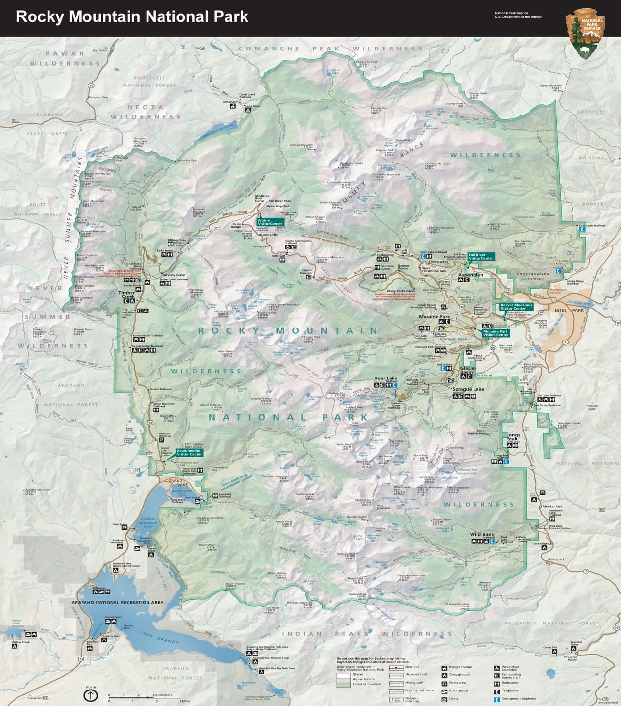
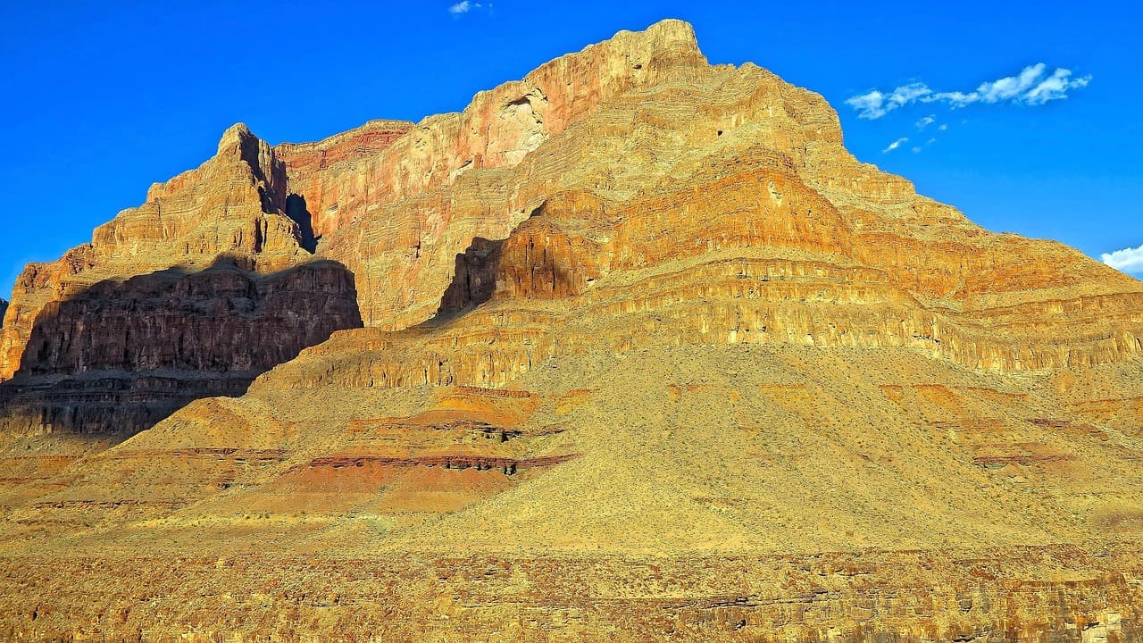
Arrive while the tundra is still catching first light and the boardwalk is yours alone — by 10am this same overlook fills with midday traffic. The air up here is thin and sharp, carrying the mineral scent of alpine soil, and if you're patient and quiet you'll likely hear a marmot whistle somewhere in the rockfield below. This is the easiest full immersion into tundra ecology on the entire drive, with interpretive signs worth lingering over for a solo traveler unhurried by anyone else's pace.
Rock Cut
Photo by nextvoyage on Pixabay
Shoot the boardwalk curving through tundra vegetation in the low morning light — the long shadows make the low-growing plants pop with texture.
Flat boardwalk with frequent benches; fully wheelchair accessible.
15 min driveA short climb north along Trail Ridge Road itself, switchbacks tightening as the trees thin out around you.
8:50 AM - 9:15 AM
Many Parks Curve · morning · 20 min · Trail Ridge Road Scenic Corridor

A short, sharp hairpin stop where the Continental Divide suddenly reveals itself across Forest Canyon — the kind of view that makes solo travelers stop mid-sentence, except there's no one to talk to but the wind. It's quick, low-effort, and worth every minute for the north-facing overlook alone.

Many Parks Curve
inkknife_2000 (7.5 million views +) / wikimedia (CC BY-SA 2.0)
The north-facing overlook across Forest Canyon toward the Divide is strongest in morning light before haze builds.
Not wheelchair accessible; uneven ground with no formal path and no benches.
5 min driveBarely a few minutes south, though the elevation gain is enough to make your ears pop again.
9:35 AM - 10:35 AM
Alpine Visitor Center · midday · 60 min · Trail Ridge Road Scenic Corridor

Step inside the highest visitor center of its kind, at 11,796 feet, where exhibits explain the tundra ecosystem you've just been walking through and rangers are usually happy to chat with a solo traveler about trail conditions or wildlife sightings — a good low-key social touchpoint for the day. The gift shop's bell and warm indoor air feel almost novel after the wind outside, and this is your fallback shelter if weather turns.

Alpine Visitor Center
inkknife_2000 (7.5 million views +) / wikimedia (CC BY-SA 2.0)
The west-facing overlook just outside the center is best saved for golden hour on your way back down, but midday still delivers striking long-distance clarity.
Fully wheelchair accessible with flat paths and frequent benches; most exhibits are indoors.
Breakfast
Trail Ridge Cafe $
Cafe/Coffee · Near Alpine Visitor Center
Grab a hot coffee and a quick pastry before heading up to Rock Cut — it's the only reliable indoor option this high on the mountain, so plan around it rather than expecting more elaborate fare.
Lunch
Trail Ridge Cafe $
Cafe/Coffee · Near Alpine Visitor Center
A simple, warm lunch spot at altitude — sandwiches and soup that hit the spot after a cold morning outside; options up here are limited, so consider packing extra trail snacks as backup.
If it rains: If thunderstorms or fog roll in, retreat immediately to the Alpine Visitor Center for indoor exhibits and shelter — lingering on exposed tundra during lightning is genuinely dangerous. Trail Ridge Road itself can close without warning in shoulder season; check NPS alerts before heading up.

The day begins in near-solitude at Rock Cut, where sunrise light rakes across the tundra boardwalk and the only sounds are wind and the occasional marmot whistle. From there, a quick hop north to Many Parks Curve delivers one of the most dramatic Continental Divide views on the drive, low-effort and high-reward for a solo traveler moving at their own pace.

By late morning, the Alpine Visitor Center offers both shelter and context — this is where the ecosystem you've been walking through gets explained, and where a chat with a ranger can turn a solo day into a slightly more social one. Grab something simple at the Trail Ridge Cafe before the midday crowds start filling the parking areas.

With the high-altitude portion of the day behind you, descend toward Estes Park for dinner and a proper thaw-out; the town's casual bar seating and communal tables make for easy solo dining, a good place to swap trail notes with fellow travelers before an early night ahead of tomorrow's lake hike.

Alpine lakes and reflection

Day 2: Mirror Lakes and Mountain Reflections

A moderately active day covering roughly 3-4 miles of walking across two lake-focused clusters, balancing an early strenuous option with an easy, accessible finish.

Wear
Sturdy hiking shoes with good tread, moisture-wicking layers, a waterproof shell for likely afternoon showers, and trekking poles if you have them for the uneven lake-loop terrain.
Budget
$50-70 (trailhead parking/shuttle if applicable, packed lunch or cafe stop in Estes Park, dinner)
7:00 AM - 9:00 AM
Bear Lake · morning · 120 min · Bear Lake & Emerald Lake Corridor

Arrive by 7am and the lake is glass-still, Hallett Peak's reflection unbroken by wind or ripples — by 9am the parking area fills and the trail gains company fast. The full loop plus a short spur toward Nymph Lake offers a solo traveler a satisfying two hours of quiet, dramatic scenery without committing to a full-day trek, and the exposed granite faces rising straight up from the shoreline are genuinely humbling at this hour.

Bear Lake
inkknife_2000 (7.5 million views +) / wikimedia (CC BY-SA 2.0)
Shoot the shoreline with Hallett Peak's reflection in the first hour after sunrise, before any wind disturbs the water's surface.
Not wheelchair accessible; unpaved and uneven terrain around the lake loop.
25 min driveA short backtrack along the park road, passing through lodgepole pine forest that thickens as elevation drops.
12:30 PM - 1:30 PM
Sprague Lake · afternoon · 60 min · Sprague Lake Loop

A deliberate pace-shift after the morning's more strenuous terrain — Sprague Lake's flat boardwalk loop is gentle on tired legs and delivers the same Hallett Peak grandeur with a fraction of the effort. The boardwalk midpoint facing Flattop and Hallett Peak is the classic postcard shot, and the quieter far shore near the old dam site offers a peaceful, less-trafficked spot to simply sit for a while.

Sprague Lake
U.S. National Park Service, restoration/cleanup by National Park Maps (https://npmaps.com) / wikimedia (Public domain)
Midday light flattens the reflection somewhat, but the boardwalk midpoint view of Flattop and Hallett Peak still delivers a strong, classic composition.
Fully wheelchair accessible boardwalk loop with frequent benches — the easiest lake experience in the park.
Optional detour: Sky Pond TrailCould replace Bear Lake as an all-day option for experienced solo hikers
The turquoise glacial water and dramatic upper basin scenery are unmatched for a serious hiker seeking the park's crown-jewel trail. Skip if: At 8+ hours round-trip with intense exertion and real lightning exposure risk, it overwhelms a 2-day standard-pace itinerary and isn't recommended solo without prior high-altitude hiking experience and an early-morning start well before dawn.
If it rains: If storms build, abandon any exposed trail immediately and head to the flat, low-elevation Sprague Lake boardwalk, which remains passable in light rain — or shorten the visit to just the main overlook section if downpours intensify.

The day opens with an early arrival at Bear Lake, where stillness and solitude reward anyone willing to beat the crowds — Hallett Peak's reflection sits undisturbed in the cold morning air, and the short loop trail feels earned rather than rushed. This is the day's physical high point, both literally and in terms of exertion.

After the morning's climb and descent, Sprague Lake offers a deliberate change of pace: flat, accessible, and easy on legs that have already done real work today. The boardwalk loop is short enough to feel restorative rather than like another task, and the mountain backdrop doesn't lose any of its power just because the walk is gentler.

With both lake experiences behind you, head back toward Estes Park for a relaxed final evening — pack a picnic or plan your meal in town since trailhead dining options are limited, and consider settling into a spot with bar seating or communal tables where solo travelers often end up trading trail stories with strangers before calling it a night well before 11pm.

Want to tweak this trip?

Our AI planner can customize this itinerary to your exact dates, interests, and travel style.

Customize This Itinerary
Good to Know

Restaurant details (hours, menus, availability) change frequently, especially in seasonal mountain towns. Check current hours before visiting.

Dietary compatibility tags are general guidance. If you have severe allergies, confirm directly with the restaurant or cafe.

Travel tips are general guidance, not professional safety advice. Altitude, weather, and road conditions change rapidly on Trail Ridge Road — check NPS alerts and government advisories before your trip.

All prices are approximate and may vary seasonally, particularly around park entrance fees and shoulder-season road access.

We use cookies to improve your experience and analyze site usage. Essential cookies are always active. You can customize your preferences or accept all cookies. Cookie Policy