3 DaysSolo Traveler8 Stops

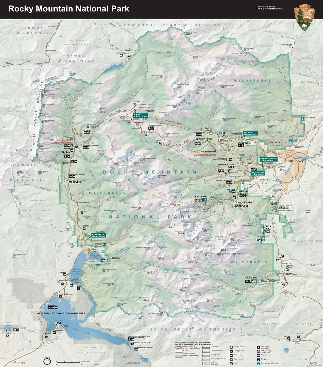
Rocky Mountain NP (Trail Ridge Road), Colorado

3-Day Itinerary for Solo Traveler

Tundra Light: 3 Days Solo on Trail Ridge Road

Tundra Light: 3 Days Solo on Trail Ridge Road

Above 11,000 feet, the road runs out of trees and hands you the whole sky — tundra grasses trembling in a wind that never quite stops. Spring means wildflowers pushing through retreating snowbanks, thinner crowds than summer, and weather that can flip from sun to sideways sleet in the time it takes to zip a jacket. Come alone and the silence up here feels less like solitude and more like company.

At a Glance

Climate & Weather
Spring in the high country is a moody, layered affair — expect mild days near 45°F at elevation, sudden rain or even snow squalls above 11,000 feet, and blooming wildflowers at lower elevations. Pack a waterproof shell, warm layers, gloves, and sun protection; conditions can shift within an hour.
Getting Around
A personal vehicle is essential — there's no public transit on Trail Ridge Road itself. Base in Estes Park for the most restaurant and social variety, and expect the road itself to demand full attention: no shoulder-checking texts, no distracted driving on the switchbacks.
Budget
Budget roughly $60–90/day for a solo traveler — park entrance fees, casual lodge or cafe meals, and the odd gift shop souvenir. Gas for the mountain driving adds a bit on top.
Safety
Solo travelers should tell someone their route and expected return time before any hike, especially on Trail Ridge Road where cell service disappears. Altitude affects everyone differently — go slow, hydrate constantly, and descend immediately at any sign of headache, nausea, or dizziness. Afternoon thunderstorms are a serious lightning risk above treeline; plan to be off high alpine terrain by early afternoon, and always give elk and marmots wide berth.
Connectivity
Cell coverage is unreliable to nonexistent along most of Trail Ridge Road and in the Bear Lake corridor; download offline maps before heading up. Estes Park and Grand Lake have reliable WiFi and signal in town.
Local Tips
Arrive at trailheads and overlooks by 7:30 AM — by 9 AM, parking lots fill and the tundra's silence gives way to chatter. Spring's shoulder-season crowds are gentler than summer's, but the road can still close without warning after a late snowfall, so check NPS alerts the morning of. Solo diners will find easy camaraderie at bar seating in Estes Park's brewpubs, where fellow hikers swap trail notes over a pint.

Highlights

  • Sunrise at Rock Cut with the tundra entirely to yourself
  • Hairpin views of the Continental Divide at Many Parks Curve
  • Hallett Peak mirrored in the still water of Bear Lake
  • The accessible boardwalk loop at Sprague Lake for easy solo miles
  • Thin-air exhibits and pika-spotting at the Alpine Visitor Center
  • Shoulder-season quiet on trails that are shoulder-to-shoulder by July

Day-by-Day Plan

Orientation and altitude

Day 1: Arrival and the Long Climb Into Sky

A gentle first day acclimating to elevation with an easy scenic drive and short walks — about 2 miles total, low-to-moderate energy.

Wear
Layers are non-negotiable: a base layer, warm mid-layer, and waterproof shell, plus sturdy walking shoes and a hat for wind.
Budget
$50–70 (park entrance fee, casual lunch, coffee stops)
9:00 AM - 9:20 AM
Many Parks Curve · morning · 20 min · Trail Ridge Road Scenic Corridor

This hairpin turn is where the road first reveals what it's climbing toward — the Continental Divide laid out across Forest Canyon, jagged and improbably close. Thin air catches you off guard even this early in the drive; take it slow getting out of the car. Arrive before 10 AM and you'll likely have the pullout to yourself, watching your breath fog in June air.

Many Parks Curve
inkknife_2000 (7.5 million views +) / wikimedia (CC BY-SA 2.0)
Shoot north across Forest Canyon toward the Divide; morning light is soft and even here, before the midday haze sets in.
No paved path and no benches — footing is uneven gravel, so wear supportive shoes.
15 min driveA slow, deliberate climb along switchbacks — every bend opens a new slice of horizon.
9:45 AM - 10:30 AM
Alpine Visitor Center · midday · 45 min · Trail Ridge Road Scenic Corridor

At 11,796 feet, the visitor center feels like a small outpost at the edge of the world — tundra stretching in every direction, pikas chirping somewhere in the rocks. Indoors, exhibits explain how anything survives up here; it's a good gentle re-set for lungs working harder than usual. The gift shop and restrooms make this a natural first full stop of the trip.

Alpine Visitor Center
inkknife_2000 (7.5 million views +) / wikimedia (CC BY-SA 2.0)
The west-facing overlook outside the center is best around midday for clear, high-contrast peak shots.
Fully wheelchair accessible with flat paths and frequent benches — the easiest stop of the day.
10 min driveA short hop south along the ridge — radio off, windows cracked to feel the cold thin air.
11:00 AM - 11:45 AM
Rock Cut · afternoon · 45 min · Trail Ridge Road Scenic Corridor

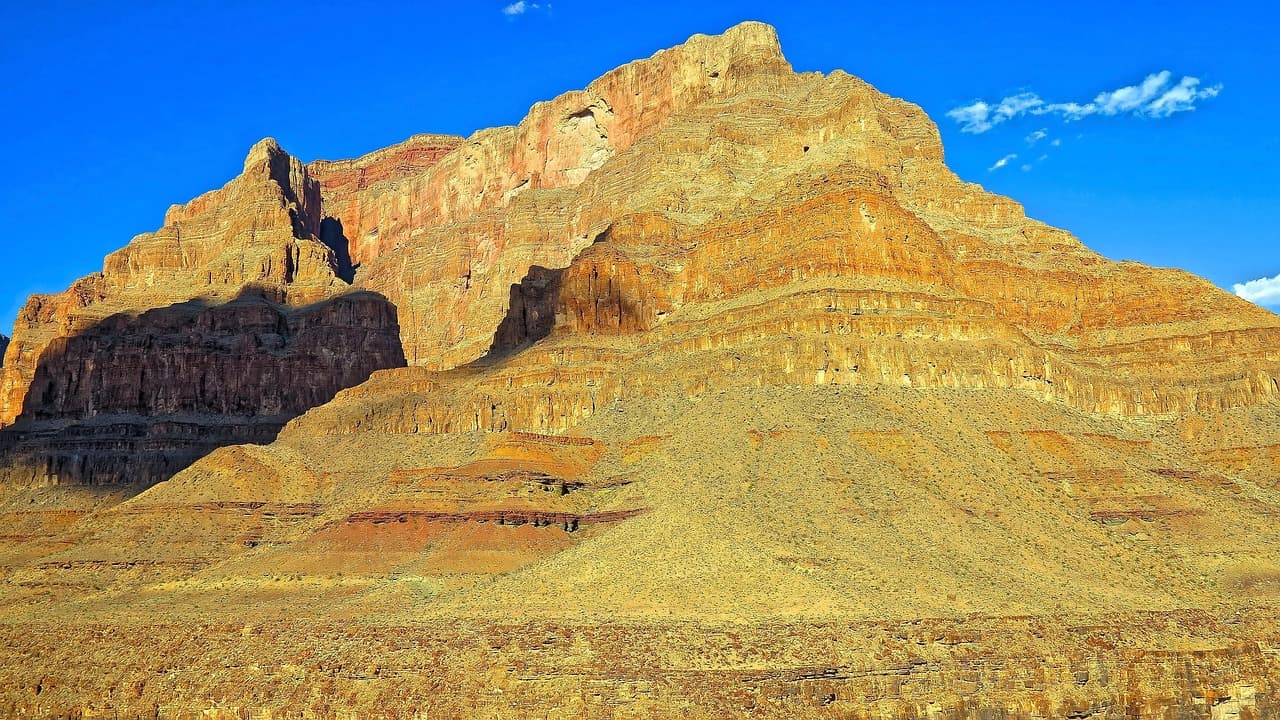
A short boardwalk here threads directly through living tundra — miniature wildflowers, wind-flattened grasses, and 360-degree granite horizons. It's an easy, flat walk that rewards patience: sit on a bench, let your eyes adjust to the scale, and watch for marmots sunning on the rocks. This is the kind of solitude that's rare come July, so treasure the quiet.
Rock Cut
Photo by nextvoyage on Pixabay
Late morning light flattens shadows nicely on the boardwalk; return at golden hour on a future day for deeper contrast.
Fully accessible boardwalk with frequent rest benches — ideal if altitude is making you feel winded.
Lunch
Trail Ridge Cafe $
Cafe/Coffee · Alpine Visitor Center
A simple, no-frills spot to refuel with soup or a sandwich after the morning's altitude gain — solo-friendly counter seating makes it easy to strike up conversation with fellow travelers comparing notes on the drive up.
If it rains: If thunderstorms roll in, retreat into the Alpine Visitor Center for exhibits and gift shop browsing, or descend to lower elevation immediately — lightning risk on the open tundra is serious and not worth waiting out.

The day begins with the long, deliberate climb up Trail Ridge Road, elevation ticking upward with each switchback. Many Parks Curve is the first jolt of scale — the Divide suddenly visible, vast and close, air noticeably thinner than it was in Estes Park. This is a day for pacing yourself; the altitude asks for patience, not ambition.

Midday brings a settling-in at the Alpine Visitor Center, equal parts rest stop and outdoor classroom, before the short tundra walk at Rock Cut. Both stops stay easy on the legs and lungs, letting the body adjust before tomorrow's longer hikes. The boardwalk at Rock Cut, in particular, offers a rare kind of quiet — wind, distant marmots, nothing else.

Head back down to Estes Park as afternoon light softens, settling into town for an early dinner and a slow evening. This is the night to hydrate deliberately, review tomorrow's trail notes, and let the body fully acclimate before more demanding terrain.

Alpine lakes and endurance

Day 2: Lakes, Reflection, and the Long Climb to Sky Pond

A full, active day in the Bear Lake corridor with a challenging option for strong hikers — up to 9 miles round trip if tackling Sky Pond, moderate to intense energy.

Wear
Sturdy hiking boots, moisture-wicking layers, waterproof shell, gloves, and a sun hat; carry poles if attempting Sky Pond.
Budget
$40–60 (trail snacks, packed lunch, any gear rental)
7:00 AM - 9:00 AM
Bear Lake · morning · 120 min · Bear Lake & Emerald Lake Corridor

Arrive by 7 AM and the lake is glass-still, Hallett Peak's reflection unbroken by ripples or crowds. This is the golden window solo travelers should claim — by 9 AM the parking lot fills and the shoreline gets busy with families and tour groups. Walk the full loop slowly, then decide: an easy morning, or the first steps of something much longer.

Bear Lake
inkknife_2000 (7.5 million views +) / wikimedia (CC BY-SA 2.0)
Shoot the shoreline reflection of Hallett Peak in the first hour of light, before wind ripples the water.
Unpaved and uneven in sections — not wheelchair accessible, but manageable for most walking abilities.
15 min walkThe trailhead splits off near Bear Lake's edge — a quiet moment before the real climb begins.
9:15 AM - 5:15 PM
Sky Pond Trail · midday · 480 min · Bear Lake & Emerald Lake Corridor

This is the day's centerpiece for anyone with the legs and lungs for it — a demanding, all-day ascent to turquoise glacial water ringed by permanent snow. The trail tests you in stages: forest, waterfalls, then bare granite fields where marmots whistle and the air turns razor-thin. Solo hikers should start early, tell someone the plan, and turn back at any sign of afternoon storm clouds — this terrain offers zero shelter from lightning.

The switchback traverse around mile 3.5 gives the best wide-angle vista; save summit shots at Sky Pond itself for midday sun on the water.
Not feasible for mobility-impaired visitors — steep, rocky, and technical in sections.
Optional detour: Bear Lake (short loop only)Between arrival and departure for Sky Pond Trail
For those not attempting Sky Pond, the Bear Lake loop alone makes a satisfying, easy-to-moderate half-day with strong photo payoff. Skip if: Skip the extended loop if you're saving energy for the full Sky Pond ascent — no need to double up on similar terrain.
If it rains: If storms threaten above treeline, descend immediately — there is no indoor shelter on Sky Pond Trail. Those not attempting the full hike should treat Bear Lake's shorter loop as the day's fallback, since it stays lower and safer in shifting weather.

Early light on Bear Lake is the reward for rising before dawn — cold air, mirror-still water, and Hallett Peak looming without a single other hiker in frame. From here, the day forks: a relaxed lake walk, or the first steps toward Sky Pond's demanding 8-hour round trip.

For those pressing on, the climb toward Sky Pond stretches through changing terrain — forest giving way to waterfalls, then bare granite basins where the air feels almost solid with cold. Every hour brings a wider view and a harder-earned one; this is not a hike to rush, and turning back early is always the right call if weather shifts.

Whichever version of the day unfolds, evening calls for rest — sore legs, an early dinner back in town, and an easy night. Tomorrow's pace is gentler, which after a day like this feels like its own kind of reward.

Gentle wandering and departure

Day 3: Easy Miles and Last Light on the Peaks

A lighter final day with accessible walking and reflective time — about 1.5 miles total, low energy, ideal for savoring rather than pushing.

Wear
Comfortable layers, light rain jacket just in case, and easy walking shoes — no technical gear needed today.
Budget
$30–50 (casual meals, any last souvenirs)
7:30 AM - 8:30 AM
Sprague Lake · morning · 60 min · Sprague Lake Loop

After yesterday's exertion, this half-mile boardwalk loop feels like a gift — flat, easy, and quietly beautiful, with Hallett and Flattop Peak framed perfectly across still water. Early arrival means Clark's nutcrackers calling and almost no one else on the boardwalk; by mid-morning, families and casual visitors start to arrive. It's a good, low-effort stop for a solo traveler wanting to slow down and simply look.

Sprague Lake
U.S. National Park Service, restoration/cleanup by National Park Maps (https://npmaps.com) / wikimedia (Public domain)
Midpoint on the boardwalk facing Flattop and Hallett Peak gives the classic postcard shot — best in the first hour after sunrise.
Fully wheelchair accessible boardwalk with frequent benches — the easiest, most restful stop of the trip.
35 min driveThe climb back up Trail Ridge Road, retracing familiar switchbacks that feel less intimidating the second time.
11:00 AM - 11:45 AM
Rock Cut · afternoon · 45 min · Trail Ridge Road Scenic Corridor

One last pass through the tundra before heading down — this time with the wildflowers likely more open than on day one, and a slower, more reflective pace. Standing at 12,000 feet on your final day gives a natural sense of closure: the same wind, the same wide light, but a body that's more used to the thin air by now.

Rock Cut
Photo by nextvoyage on Pixabay
Late morning light works well here; if time allows, this is also a strong spot for a final wide-angle panorama before departure.
Fully accessible boardwalk with frequent benches, ideal for an easy final outdoor stop.
Optional detour: Many Parks CurveAfter Sprague Lake and before Rock Cut
A quick five-minute pullover for one last hairpin view of the Divide on the way back up the mountain. Skip if: Skip if you've already lingered here on day one and want to preserve time for a slower goodbye at Rock Cut instead.
If it rains: If rain moves in, shorten the Sprague Lake walk to the main overlook section and skip the return trip up to Rock Cut — the lower-elevation boardwalk stays safer and more pleasant in wet weather.

The final morning eases in gently at Sprague Lake, where flat boardwalks and mirror-still water make for an unhurried start. This is the kind of stop that rewards slowness — no climb, no altitude strain, just peaks reflected in calm water and birdsong.

One last climb up Trail Ridge Road brings a final look at the tundra from Rock Cut, wildflowers a little further along than they were on arrival day. It's a fitting bookend — the same landscape, but a traveler more attuned to its scale and quiet by now.

With the drive back down complete, the evening is free for a relaxed final dinner in Estes Park before departure — a good time to trade trail stories with fellow travelers at a bar seat, or simply sit with the quiet satisfaction of three days spent above the treeline.

Want to tweak this trip?

Our AI planner can customize this itinerary to your exact dates, interests, and travel style.

Customize This Itinerary
Good to Know

Restaurant details (hours, menus, availability) change frequently. Check current hours before visiting, especially in seasonal destinations.

Dietary compatibility tags are general guidance. If you have severe allergies, confirm directly with the restaurant.

Travel tips are general guidance, not professional safety advice. Check government advisories and NPS alerts for the latest road and weather conditions before heading out.

All prices are approximate and may vary seasonally.
We use cookies to improve your experience and analyze site usage. Essential cookies are always active. You can customize your preferences or accept all cookies. Cookie Policy