3 DaysSolo Traveler8 Stops

Daniel Boone NF (Stearns, London), Kentucky

3-Day Itinerary for Solo Traveler

โ€œFalls, Fog, and Firelight: A Solo Wander Through Daniel Boone National Forestโ€

Falls, Fog, and Firelight: A Solo Wander Through Daniel Boone National Forest

Mist rises off the Cumberland before sunrise, wildflowers crowd the trail edges, and the only footsteps on the Laurel River Trail this early are your own. This is spring in Daniel Boone National Forest โ€” quiet, green, and made for a traveler with no one to keep pace with but themselves.

At a Glance

Climate & Weather
Spring days run mild, 56โ€“63ยฐF, with cooler mornings and evenings โ€” pack a rain jacket, a warm layer for dawn hikes, and quick-dry clothing since spring showers arrive without much warning. Trails can be muddy; waterproof footwear is worth the extra weight in your pack.
Getting Around
A car is essential; distances between clusters run 30โ€“45 minutes on winding mountain roads. Cumberland Falls and Big South Fork's north end sit far enough apart that they're best tackled on separate days rather than combined.
Budget
Budget roughly $50โ€“75/day for a solo traveler covering meals, the scenic railway ticket, and incidentals โ€” dining is affordable and portions are generous, so you won't need to spend much to eat well.
Safety
Very safe for solo travelers, but let someone know your trail plan and expected return time, especially before longer hikes like the Laurel River Loop. Stay on marked paths, respect river currents near Big South Fork, carry a paper map or offline GPS since cell service is patchy, and store food properly โ€” black bears are present, though encounters are rare if you're not careless with food.
Connectivity
Cell coverage is inconsistent throughout the forest, especially in gorge areas and along trails โ€” download offline maps before heading out. WiFi is generally reliable at lodges and in Stearns/London town centers.
Local Tips
Weekday mornings mean you'll often have overlooks entirely to yourself โ€” arrive before 8am whenever possible. Check the lunar calendar before your trip; moonbow viewing only happens on clear nights around the full moon. Businesses close early here, so plan dinner by 7-8pm rather than assuming late-night options.

Highlights

  • Standing alone at the rim as Cumberland Falls roars into its 68-foot drop
  • Chasing the rare moonbow on a clear spring night
  • Six solitary miles along the Laurel River's cascades and creek crossings
  • A vintage rail journey through the sandstone walls of Big South Fork gorge
  • Appalachian comfort food at family-run tables where conversation comes easy
  • Wildflower season carpeting the forest floor in April and May

Day-by-Day Plan

Arrival & orientation

Day 1: Settling In at the Falls

A gentle first day centered entirely on the Cumberland Falls Area, with light walking (around 2 miles) and plenty of rest between stops to ease into forest time.

Wear
Layered clothing with a light rain jacket, sturdy walking shoes (not necessarily hiking boots yet), and a hat for sun and mist protection near the falls.
Budget
$45-60 for meals and incidentals
8:00 AM - 9:30 AM
Cumberland Falls (moonbow) ยท morning ยท 90 min ยท Cumberland Falls Area

Arrive by 8am and the overlook is yours โ€” no shuffling crowds, just the deafening roar of 3,600 gallons a second plunging 68 feet into the gorge below. Mist drifts up and settles cool on your skin; the air smells of wet stone and dark forest soil. Take the lower trail toward the base for a closer, louder encounter with the spray before the day-trippers arrive.

Cumberland Falls (moonbow)
Bernice Chmarouski / pexels (Pexels License)
Shoot from the upper rim trail just after sunrise, when soft light catches the full cascade without harsh shadows.
Paths are uneven and unpaved in sections; sturdy footwear recommended, and benches are sparse along the route.
15 min walk โ€” A short walk along the park road connects the falls overlook to the Laurel River trailhead, with wildflowers already crowding the verges in April.
10:15 AM - 12:15 PM
Laurel River Trail Loop ยท midday ยท 120 min ยท Cumberland Falls Area

Rather than the full six-mile loop on day one, ease in with the first stretch โ€” about two miles out and back to the first cascade junction. The trail is quiet even on weekends, just the percussion of falling water and the occasional songbird cutting through the rush of the Laurel River. It's an easy, low-pressure way to get your legs under you before the longer stretches later in the trip.

Laurel River Trail Loop
Photo by Deb Hayes on Pexels
The first cascade junction offers a clean foreground-to-background shot โ€” water in front, forest layered behind.
Trail is not wheelchair accessible; uneven terrain and occasional creek crossings.
10 min drive โ€” A short evening drive back to the falls area, headlights catching moths and the occasional deer at the roadside.
8:30 PM - 10:00 PM
Cumberland Falls (moonbow) ยท evening ยท 90 min ยท Cumberland Falls Area

If tonight lands near a clear full moon, return after dark for one of nature's rarest sights: moonlight bending through the falling water into a silver arc few people ever witness. Photographers and astronomy enthusiasts tend to cluster near the main overlook on these nights, making it an easy, low-key way to strike up conversation with fellow solo travelers waiting for the same shot. Bring a headlamp for the walk back and dress warmer than you think you'll need โ€” the gorge holds a chill after sundown.

Cumberland Falls (moonbow)
Bernice Chmarouski / pexels (Pexels License)
Use a tripod and long exposure; the moonbow is faint to the naked eye but often more vivid on camera.
Uneven terrain in low light โ€” bring a headlamp and use caution near the gorge edge.
If it rains: Heavy rain and fog will obscure the falls and cancel any moonbow viewing entirely โ€” if this happens, treat day one as a lighter orientation day, and shift outdoor exploration to daylight hours only, keeping to the lower falls trail in light rain if conditions allow.

The forest wakes up slowly, and so should you. Arrive at Cumberland Falls while the light is still soft and the overlook empty, letting the sheer scale and sound of the water settle in before anyone else arrives. It's the kind of quiet that makes solo travel feel less like being alone and more like having the whole place handed to you.

After the falls, ease into the Laurel River Trail for an unhurried few miles โ€” no rush, no itinerary pressure, just creek crossings and cascades and the particular kind of solitude this trail is known for. This is a light day by design, giving your legs and your nervous system time to adjust to forest pace.

If the moon cooperates, return after dinner for the moonbow โ€” a genuinely rare phenomenon and a quietly social moment, since the handful of people gathered at the overlook after dark tend to be there for the same reason you are. If clouds roll in, a quiet dinner in Stearns or London and an early night sets you up well for the more active days ahead.

Solitude & trail immersion

Day 2: Deep Into the Laurel River

A full hiking day covering the remainder of the Laurel River Trail Loop, totaling roughly 5-6 miles of moderate walking with a strong emphasis on solo trail time and photography.

Wear
Proper hiking boots (expect creek crossings and mud), moisture-wicking layers, a rain shell, and a daypack with water and snacks since options near the trailhead are limited.
Budget
$35-50 for meals and trail snacks
10 min drive โ€” A quick morning drive through low fog still clinging to the gorge road.
7:30 AM - 10:30 AM
Laurel River Trail Loop ยท morning ยท 180 min ยท Cumberland Falls Area

Start early โ€” by 7:30am the trail is nearly silent, just the white-noise rush of the Laurel River and the occasional splash of an ankle-deep crossing. This is the trail's full loop, six miles of cascades, limestone-echoed water sounds, and soft forest floor underfoot. It rarely feels crowded even at peak season, making it an ideal solo hike where you can move at your own rhythm without apology.

Laurel River Trail Loop
Photo by Deb Hayes on Pexels
The main Laurel River crossing at mile 2.5 offers wide, still pools perfect for reflection shots in early morning light.
Not wheelchair accessible; expect creek crossings, uneven footing, and limited benches.
15 min walk โ€” The trail loop naturally deposits you back near the falls parking area, legs tired but satisfied.
12:00 PM - 1:00 PM
Cumberland Falls (moonbow) ยท midday ยท 60 min ยท Cumberland Falls Area

After the long morning hike, loop back to the falls for a shorter, calmer visit โ€” enough time to rest legs on the overlook benches and watch the water from a fresh angle now that the morning mist has burned off. Midday brings more visitors, but after a solitary morning on the trail, a little shared awe at the railing feels welcome rather than crowded.

Cumberland Falls (moonbow)
Bernice Chmarouski / pexels (Pexels License)
By midday the sun is higher and harsher โ€” aim for the lower trail viewpoint where the gorge walls offer some shade and mist-softened light.
Paths are uneven; benches are sparse but available near the main overlook.
Optional detour: Laurel River Trail Loop (extended photography loop) โ€” After the morning hike and before returning to the falls
Photographers may want an extra hour at the second cascade area for mist and layered rock formations in changing light. Skip if: If your legs are already tired from the six-mile loop, this add-on isn't worth pushing your daily mileage past the 6-mile comfort threshold.
If it rains: If rain is heavy, hike only the first 1.5 miles of the Laurel River Trail rather than the full loop โ€” creek crossings rise quickly and the trail becomes slippery underfoot, so err toward caution and save the full loop for a drier day.

This is the day the forest really opens up. Setting out early on the Laurel River Trail Loop means having six miles of cascades, creek crossings, and quiet hardwood forest almost entirely to yourself โ€” the kind of immersive solo hiking that reminds you why you came without a companion in the first place.

By midday, tired legs and a satisfied kind of quiet settle in. A short return visit to Cumberland Falls offers a chance to rest, refuel, and watch the water again with fresh eyes โ€” busier now, but companionable rather than crowded after a solitary morning.

Keep the evening simple. A relaxed dinner in town, feet up, maybe a short walk to stretch out the day's mileage โ€” tomorrow's gorge-country day asks for fresh legs and a rested mind.

Scenic drama & departure

Day 3: Gorge Country and the Rails

A shift north to Big South Fork's gorge landscapes, combining a moderate scenic hike with a relaxed scenic railway journey, totaling around 3-4 miles of walking.

Wear
Layered clothing for temperature swings between the open gorge overlooks and the covered train cars, sturdy shoes, and a light jacket for the breeze through open train windows.
Budget
$60-80 including the railway ticket and meals
45 min drive โ€” A winding 45-minute mountain drive north toward Stearns, with a worthwhile pullover at any roadside overlook where the ridgelines first come into view.
8:00 AM - 10:00 AM
Big South Fork (north end) ยท morning ยท 120 min ยท Big South Fork North End

Arrive early and the gorge opens before you almost without warning โ€” cool mountain air, the distant rush of whitewater bouncing off sandstone cliffs, the smell of damp earth and hemlock. By 8am the overlooks are still quiet, giving you room to sit with the scale of the canyon before the day's foot traffic picks up. The elevated ridge viewpoint near the trail terminus offers the best sense of the gorge's full depth.

Big South Fork (north end)
United States. Soil Conservation Service / wikimedia (Public domain)
Morning light rakes across the gorge walls from the north rim overlook โ€” arrive before 9am for the clearest, least hazy shots.
Limited accessible trails; terrain is uneven with minimal benches along the route.
15 min drive โ€” A short drive back toward Stearns station, gorge views receding in the rearview mirror.
11:00 AM - 2:00 PM
Big South Fork Scenic Railway ยท midday ยท 180 min ยท Big South Fork North End

Trade hiking boots for a train seat and let the gorge come to you instead. The rhythmic clack of steel wheels, cool air rushing through open windows, and sheer sandstone bluffs rising from the emerald river below make this an easy, restful counterpoint to two days of hiking. It's also a naturally social ride โ€” shared benches and open-air cars make conversation with fellow solo travelers easy, especially around the mile 3-4 gorge vista when everyone leans toward the same window.
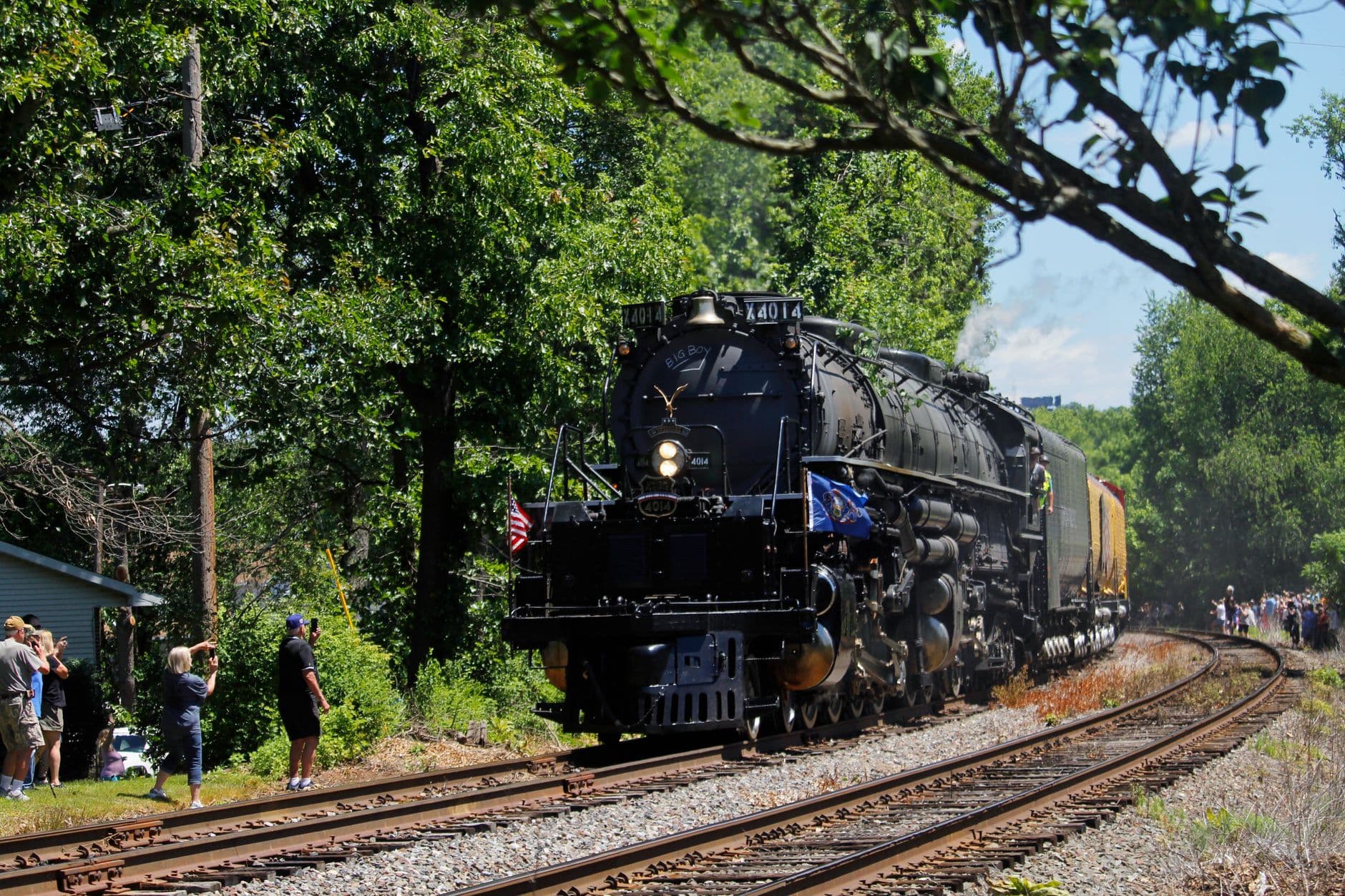
Big South Fork Scenic Railway
Photo by Sephina Cornwall on Pexels
The best gorge vista comes around mile 3-4 aboard the train โ€” sit on the river side for unobstructed shots.
Boarding accommodations are available; speak with station staff in advance for accessibility needs.
Optional detour: Big South Fork (north end) โ€” ridge viewpoint extension โ€” After the morning gorge visit and before boarding the scenic railway
An extra 30 minutes at the elevated ridge viewpoint rewards photographers with the canyon's full depth in clearer late-morning light. Skip if: If you want to arrive early for railway boarding and avoid the midday crowd rush, skip the extension and head straight to the station.
If it rains: Trails around Big South Fork become slippery in wet weather โ€” if rain sets in, the railway itself often still operates in light rain, so shift the day's emphasis toward the train ride and treat the gorge hike as optional; check departure status 48 hours ahead if rain is heavier.

The final day trades misty waterfalls for dramatic gorge country. Arriving early at Big South Fork's north end means the overlooks are still hushed, giving you space to take in the sheer scale of the canyon before it fills in with midday visitors.

The pace shifts entirely for the afternoon โ€” instead of another hike, settle into a seat aboard the Big South Fork Scenic Railway and let the gorge scroll past the window. It's a fitting, low-effort finale that still delivers the same dramatic sandstone views, just from a slower, more social vantage point.

With the railway excursion wrapping by mid-afternoon, the evening opens up for an easy dinner in Stearns or London and a final quiet walk to close out the trip โ€” no need to rush the goodbye to a forest that rewards exactly this kind of unhurried departure.

Want to tweak this trip?

Our AI planner can customize this itinerary to your exact dates, interests, and travel style.

Customize This Itinerary
Good to Know

Restaurant details (hours, menus, availability) change frequently. Check current hours before visiting, especially in seasonal destinations.

Dietary compatibility tags are general guidance. If you have severe allergies, confirm directly with the restaurant.

Travel tips are general guidance, not professional safety advice. Check government advisories for latest information.

All prices are approximate and may vary seasonally.

We use cookies to improve your experience and analyze site usage. Essential cookies are always active. You can customize your preferences or accept all cookies. Cookie Policy