3 DaysTeen Families8 Stops

Daniel Boone NF (Stearns, London), Kentucky

3-Day Itinerary for Teen Families

โ€œFalls, Rails & Firelight: 3 Days in Daniel Boone National Forestโ€

Falls, Rails & Firelight: 3 Days in Daniel Boone National Forest

Mist rises off the Cumberland River before sunrise, and somewhere in the gorge a train whistle echoes off sandstone walls older than memory. This is a forest built for teenagers who roll their eyes at museums but lean forward at cliff edges โ€” three days of waterfalls, vintage rail cars, and enough autonomy to make it feel like their trip too.

At a Glance

Climate & Weather
Expect warm to hot days (upper 70sโ€“mid 80sยฐF) with high humidity and occasional afternoon thunderstorms typical of Kentucky summers. Pack lightweight moisture-wicking layers, a rain shell, sturdy hiking shoes that can get wet, and swimwear for creek crossings. Mornings can still feel cool near the water, so a light layer helps for early starts.
Getting Around
A car is essential โ€” the forest connects via winding mountain roads (US-27, KY-90) with no public transit between clusters. Plan extra time for narrow, curvy stretches, and fuel up in Stearns or London before heading into more remote sections.
Budget
Budget roughly $60โ€“100 per day per family member for food and activities, factoring in the scenic railway ticket, state park parking/access fees, and casual sit-down meals.
Safety
Stay on marked trails and respect posted river current warnings, especially near Big South Fork and the Laurel River crossings. Black bears live in the forest โ€” store snacks sealed and don't leave food unattended at overlooks or picnic stops. Cell service is spotty in gorge areas, so let teens know check-in points in advance if you allow independent exploring.
Connectivity
Cell coverage is inconsistent to nonexistent within gorge areas and along trails; expect reliable signal mainly in Stearns and London town centers. Download offline maps and let teens know where the last strong-signal point was before hiking.
Local Tips
Arrive at trailheads and overlooks by 7:30โ€“8am in summer โ€” both for cooler hiking temperatures and to beat the weekend crowd crush. Check the lunar calendar before your trip; moonbow viewing only happens on clear nights around the full moon, so it may require a reservation-style mindset even though it's free. Most local restaurants close early, so plan dinner by 7pm rather than counting on late-night options.

Highlights

  • Chase the rare moonbow at Cumberland Falls under a clear summer sky
  • Ride a vintage train through the Big South Fork gorge
  • Wade cool creek crossings on the Laurel River Trail
  • Stand at the north rim overlook as the gorge opens beneath you
  • Early starts that beat both the heat and the crowds
  • Casual Appalachian comfort food after long trail days

Day-by-Day Plan

Arrival & Orientation

Day 1: First Light on the Falls

A lighter day easing into the forest with roughly 2 miles of walking, centered on the dramatic payoff of Cumberland Falls and a gentler introduction to trail life.

Wear
Quick-dry shorts or leggings, moisture-wicking t-shirt, broken-in hiking shoes or trail sandals with grip, sun hat, and a light rain shell tucked in a daypack.
Budget
$70โ€“90 for the family (lunch, dinner, park parking, snacks)
7:30 AM - 9:00 AM
Cumberland Falls (moonbow) ยท morning ยท 75 min ยท Cumberland Falls Area

Arrive while the parking lot is still half-empty and the falls are doing their loudest, most theatrical performance of the day โ€” 3,600 gallons a second thundering 68 feet down, throwing cool mist that beads on sunglasses and skin alike. By 9am this overlook fills with shoulder-to-shoulder crowds, but the early window belongs almost entirely to you and whoever else got the same idea. Teens tend to underestimate waterfalls until they feel the ground vibrate underfoot โ€” this one delivers that moment.

Cumberland Falls (moonbow)
Bernice Chmarouski / pexels (Pexels License)
Shoot from the upper rim trail just after sunrise for full-cascade light with minimal crowd in frame; save the lower trail for detailed mist shots once the sun is higher.
Paths to the main overlook are paved but uneven in sections; the lower and rim trails involve stairs and roots, so not wheelchair accessible.
10 min walk โ€” A short walk along the park road connects the falls overlook to the Laurel River trailhead, past picnic tables where early risers are already unpacking coolers.
9:30 AM - 11:30 AM
Laurel River Trail Loop ยท midday ยท 120 min ยท Cumberland Falls Area

Rather than tackling the full six miles on day one, ease in with the first stretch to the initial cascade junction โ€” ankle-deep creek crossings, cool mineral-scented air, and a soundtrack of rushing water that makes conversation optional. This is where teens get a taste of real trail autonomy: let them scout ahead to the next bend while parents catch breath at a creek crossing. The forest floor here is soft and forgiving, a gentle warm-up for bigger hikes ahead.

Laurel River Trail Loop
Photo by Deb Hayes on Pexels
The first cascade junction offers a clean foreground-water, forest-backdrop shot โ€” best in the soft, diffused light of mid-morning before the sun gets harsh overhead.
Not wheelchair accessible; trail includes creek crossings and uneven, sometimes slick terrain.
Optional detour: Laurel River Trail Loop (extended segment) โ€” After the first cascade junction and before heading back to lodging
Pushing on to the mile 2.5 river crossing rewards hikers with wider pools and reflective water perfect for photos. Skip if: On arrival day, tired legs and travel fatigue make the full loop a lot to ask โ€” save the extended mileage for day two or three.
If it rains: If rain moves in, daytime falls viewing is still worthwhile despite reduced visibility โ€” plan to skip the Laurel River Trail extension since creek crossings rise quickly and become unsafe, and instead linger longer at the falls overlook under rain shells.

The day begins with the low, steady roar of Cumberland Falls rather than an alarm clock โ€” arriving before 8am means the overlook is nearly silent except for the water itself, mist settling on shoulders as early light catches the spray. It's a soft landing into the trip, dramatic enough to wake everyone up without demanding much physical effort yet.

By midday, the pace shifts from spectacle to sensation as the group wades into the Laurel River Trail's opening stretch โ€” cool creek water on tired feet, the forest closing in overhead, teens given loose rein to explore ahead while the trail remains easy and well-trodden. This is intentionally the lightest hiking of the trip, designed to build trail legs without building trail fatigue.

Evening settles in with dinner options best sourced locally in Stearns or London โ€” ask at your accommodation for the current family-run favorite, as options shift and this guide's sources don't map every seasonal spot. Depending on the lunar calendar, this could also be a moonbow night; check conditions before turning in, because a clear sky near the full moon means a rare, otherworldly show worth staying up for.

Scenic Railway & River Views

Day 2: Rails Through the Gorge

A moderate-energy day covering roughly 2.5 miles of walking combined with a seated scenic train excursion through Big South Fork's dramatic gorge country.

Wear
Layered clothing since the train can be breezy with open windows, closed-toe walking shoes, a hat for sun at overlooks, and a light jacket for cooler morning air.
Budget
$100โ€“140 for the family (railway tickets, lunch, dinner, snacks)
50 min drive โ€” A winding mountain drive from the Cumberland Falls area to Stearns โ€” worth a stop at a scenic pullover along US-27 if anyone needs a stretch break, since the road curves for the better part of an hour.
8:30 AM - 11:30 AM
Big South Fork Scenic Railway ยท morning ยท 180 min ยท Big South Fork North End

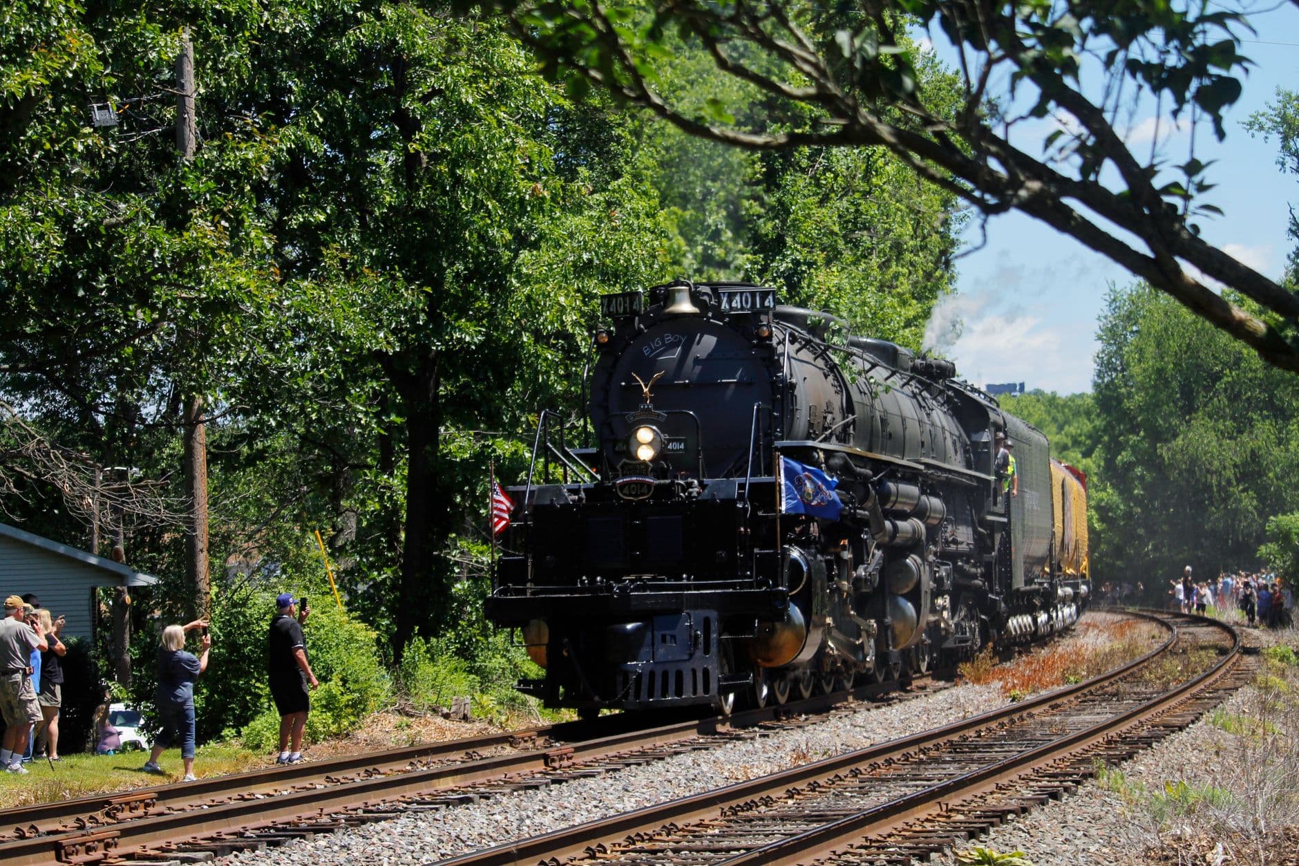
Book the earlier morning departure if possible โ€” it's quieter, cooler, and the light hits the gorge walls at a dramatic low angle around mile 3-4 where sheer sandstone bluffs rise straight from the emerald river below. The rhythmic clack of the vintage rail cars and rush of mountain air through open windows makes this the trip's highest-rated stop for teens who might otherwise resist a full day of hiking. Staff generally welcome questions about rail history, which can turn a scroll-through-phone teen into an engaged one.
Big South Fork Scenic Railway
Photo by Sephina Cornwall on Pexels
Position yourselves on the gorge-facing side of the car for the mile 3-4 vista, and catch the return approach to Stearns station in late-morning light for a classic depot shot.
Boarding accommodations are available with advance notice โ€” contact the railway office ahead of your visit if mobility assistance is needed.
15 min drive โ€” A short drive from the Stearns depot toward the gorge trailhead, winding past dense hemlock stands that shade the road.
1:00 PM - 3:00 PM
Big South Fork (north end) ยท afternoon ยท 120 min ยท Big South Fork North End

After the seated train ride, legs are ready to move again, and the north rim overlook delivers a payoff worth the walk โ€” the gorge opens suddenly and completely, cool air rising off the river far below while whitewater rush echoes faintly off the cliffs. This is a good stretch for teen independence: the trail to the terminus overlook is straightforward enough to let older kids range a bit ahead while adults take it slower. Midweek and morning hours are quietest; by mid-afternoon on summer weekends, expect more foot traffic at the main overlooks.

Big South Fork (north end)
United States. Soil Conservation Service / wikimedia (Public domain)
The north rim overlook at the trail terminus is the standout shot โ€” arrive in early afternoon light for the fullest sense of the canyon's depth.
Trails here are not wheelchair accessible and have limited benches; expect uneven terrain and no flat paved sections.
Optional detour: Big South Fork (north end) โ€” elevated ridge viewpoint โ€” After the main north rim overlook and before heading back to the car
The elevated ridge viewpoint shows the canyon's full depth and is a strong candidate for the trip's best group photo. Skip if: If the afternoon heat has worn everyone down or storm clouds are building, this extra push isn't essential to the day's experience.
If it rains: Trains generally still operate in light rain, so the railway excursion is fairly weather-resilient, but heavier rain may cancel departures โ€” check with the railway office 48 hours ahead. If the north end trails turn slippery, consider indoor alternatives such as regional museums in the Harlan/London area instead.

Morning starts with the low chug and clatter of the Big South Fork Scenic Railway pulling out of Stearns station, windows down and mountain air rushing through the car as the gorge reveals itself in dramatic increments โ€” sheer bluffs, glimpses of green river water, the occasional startled bird lifting off the canopy below.

After lunch, the pace shifts from seated wonder to walking exploration at the north end overlook, where the gorge opens wide and sudden underfoot, the roar of distant whitewater a low hum beneath conversation. This is a good stretch for teens to take the lead on the trail while parents catch the view at their own pace.

As the group heads back toward Stearns or London for the evening, dinner is best planned around whichever family-run spot is currently open in town โ€” this guide's dining sources are limited here, so it's worth asking locally rather than assuming a specific restaurant will be available. A quieter evening helps recover legs for the bigger hiking day ahead.

River Trails & Golden Hour

Day 3: Deep in the Laurel Gorge

The most physically active day, covering up to 4 miles on the extended Laurel River Trail loop with a return to Cumberland Falls for evening light or moonbow potential.

Wear
Sturdy trail shoes that can handle wet crossings, quick-dry clothing, sun protection, a swimsuit if wading is appealing, and a headlamp packed in case evening moonbow viewing extends after dark.
Budget
$70โ€“100 for the family (lunch, dinner, snacks, incidentals)
7:00 AM - 10:30 AM
Laurel River Trail Loop ยท morning ยท 210 min ยท Cumberland Falls Area

With trail legs built from the previous two days, this is the morning to push further into the Laurel River Trail โ€” past the first cascade junction toward the mile 2.5 river crossing, where wider pools throw back mirror-still reflections before the day's heat stirs the air. Starting at 7am means cooler temperatures and a trail that still feels like private territory; by late morning on a summer weekend, moderate foot traffic picks up. The rushing water and creek crossings make this section feel more like an adventure than a stroll โ€” ideal for teens who want more than a paved overlook.

Laurel River Trail Loop
Photo by Deb Hayes on Pexels
The mile 2.5 river crossing is the standout shot of the trip โ€” arrive before 9am for still water and soft light before wind picks up the surface.
Not accessible for wheelchairs; multiple creek crossings and root-covered terrain make sturdy footwear essential.
15 min drive โ€” A short return drive back toward the falls parking area, the road quieting down as day-trippers head home for the evening.
6:30 PM - 8:00 PM
Cumberland Falls (moonbow) ยท evening ยท 90 min ยท Cumberland Falls Area

Returning to the falls for golden hour offers a completely different mood than the first morning visit โ€” longer shadows, warmer light on the spray, and if conditions align with a clear sky near the full moon, the extraordinary chance to see the moonbow itself, the only reliably visible one in North America. Even without moonbow conditions, evening crowds thin out compared to midday, making this a calmer bookend to the trip. It's worth checking the lunar calendar before finalizing this evening's plan.

Cumberland Falls (moonbow)
Bernice Chmarouski / pexels (Pexels License)
The overlook platform facing the falls directly is best for golden hour shots around 6:30-7:30pm; if moonbow conditions are active, the lower trail viewpoint captures the arc most dramatically after dark.
Main overlook path is paved but uneven in places; evening visits require caution on unlit sections after dusk.
Optional detour: Laurel River Trail Loop (second cascade area) โ€” After the mile 2.5 river crossing and before turning back toward the trailhead
The second cascade area offers dramatic mist and layered rock formations that reward the extra half-mile push. Skip if: If the group is fatigued from three days of hiking or the midday heat has become intense, turning back at the main river crossing keeps the day comfortable.
If it rains: Heavy rain raises creek levels dangerously on the Laurel River Trail โ€” if conditions are wet, limit the hike to the first 1.5 miles only, and shift the evening plan away from moonbow viewing since fog and rain make the phenomenon impossible to see; daytime falls viewing remains an option even in lighter rain.

The final full day opens with the most ambitious hiking of the trip, deep into Laurel River Trail territory where creek crossings and cascades replace paved overlooks โ€” cool water underfoot, the forest thick and close, the sense of having earned this quieter, wilder corner of the park.

Midday is best spent resting and refueling after the morning's mileage, with plenty of downtime before the evening's return to the falls โ€” a natural pause point for tired legs and sun-warmed skin.

As the sun drops low, the group heads back to Cumberland Falls for a final look at the cascade in golden light, or โ€” if the moon cooperates โ€” the rare hush of standing before a moonbow arcing silently through the mist, a fitting, quietly spectacular close to three days in the forest.

Want to tweak this trip?

Our AI planner can customize this itinerary to your exact dates, interests, and travel style.

Customize This Itinerary
Good to Know

Restaurant details (hours, menus, availability) change frequently, and this guide's dining sources are limited for this region. Confirm current options locally before planning meals around a specific venue.

Dietary compatibility tags are general guidance. If you have severe allergies, confirm directly with the restaurant.

Travel tips are general guidance, not professional safety advice. Check government advisories and current park conditions before your trip.

All prices are approximate and may vary seasonally.

We use cookies to improve your experience and analyze site usage. Essential cookies are always active. You can customize your preferences or accept all cookies. Cookie Policy