3 DaysCouples8 Stops

White Mountains (North/South), New Hampshire

3-Day Itinerary for Couples

Notches, Waterfalls, and Alpine Wind: 3 Days Among the White Mountains

Notches, Waterfalls, and Alpine Wind: 3 Days Among the White Mountains

The White Mountains don't announce themselves gently—granite walls rise straight out of forest, rivers roar through notches barely wide enough for a road, and the air smells perpetually of balsam and cold stone. This is a landscape built for slow mornings and long, quiet drives together, where the reward for an early alarm is a summit or a waterfall with no one else in sight.

At a Glance

Climate & Weather
Summer in the White Mountains runs mild by lowland standards—around 68°F (20°C) in the valleys—but expect frequent afternoon showers and much colder, windier conditions at elevation, especially above treeline on Mount Washington. Pack breathable layers, a packable rain shell, and sturdy footwear even for 'easy' walks; summit conditions can swing 30+ degrees colder than the base.
Getting Around
A car is essential; distances between notches are significant and public transit is minimal. Roads are scenic but slow-going—budget extra time on the Kancamagus and through the notches, and treat drive time itself as part of the experience rather than a means to an end.
Budget
Budget roughly $150–220/day per couple for meals and activities, including one upscale dinner, park/attraction fees (Flume Gorge, Mount Washington Auto Road or Cog Railway if pursued), and casual lunches.
Safety
Mount Washington's summit weather can deteriorate in minutes regardless of the forecast at the trailhead—check the Mount Washington Observatory forecast the morning of any ascent and be willing to turn back. Black bears are present but rarely confrontational; keep food sealed in the car. Notch roads (Franconia, Crawford) are winding with limited shoulders—drive attentively, especially at dusk when wildlife crosses.
Connectivity
Cell coverage is spotty to nonexistent in the notches and on Mount Washington's lower slopes; download offline maps before heading out. Lodging in North Conway and Lincoln generally has reliable WiFi and signal.
Local Tips
Start every outdoor stop before 8:30am—by mid-morning in summer, the Flume, Kancamagus pullouts, and Franconia Notch overlooks fill with day-trippers. Locals treat the mountains as a daily ritual, not a spectacle, so dress and pace yourselves accordingly rather than rushing for photos. If Mount Washington's summit is socked in cloud, the Cog Railway or a rain-day pivot to Crawford Notch's waterfalls is a graceful backup, not a defeat.

Highlights

  • Sunrise light on Franconia Notch's granite walls with no traffic yet on the Parkway
  • Standing inside the cool, mist-cooled corridor of Flume Gorge
  • A full-day alpine pursuit of Mount Washington's summit, weather permitting
  • Cascading water and forest canopy along the Kancamagus Highway's hidden falls
  • Golden-hour photography at Echo Lake with Franconia Ridge reflected on still water
  • An upscale, unhurried dinner to close out a summit day
  • Waterfall-adjacent picnic pullouts made for two

Day-by-Day Plan

Settling in, alpine orientation

Day 1: Arrival & First Light in Franconia Notch

A gentle first day easing into the region's rhythm with a scenic notch drive, a waterfall gorge walk, and golden-hour lake views—roughly 2 miles of easy walking total.

Wear
Light layers, a light rain shell, comfortable walking shoes with good grip for damp gorge boardwalks.
Budget
$140–180 for two, including Flume Gorge admission and dinner
9:00 AM - 11:00 AM
Franconia Notch · morning · 120 min · Franconia Notch & The Flume

Ease into the trip with the Parkway itself—granite walls rising on either side like the mountains are holding their breath around you. Pull off at Profile Lake and Echo Lake for unhurried looks at the ridge doubling itself in still water; this is a drive best taken slowly, windows down, with no fixed itinerary pressure on day one.

Franconia Notch
Paleontological Research Institution (Ithaca, N.Y.) Columbia University / wikimedia (Public domain)
Echo Lake's east-facing overlook works best mid-morning to early afternoon when light hits the ridge directly; save the dramatic side lighting for another day's return trip.
Roadside pullouts are paved but uneven in places; no wheelchair-accessible path to the water's edge.
10 min driveA short hop along the Parkway itself, ridge walls sliding past the windshield the whole way
11:15 AM - 12:30 PM
Franconia Notch · midday · 75 min · Franconia Notch & The Flume

Continue along the Parkway toward Cannon Mountain's cliffs, where the vertical rock faces feel closest to the road—an easy, low-effort continuation of the morning rather than a separate exertion. This is intentionally light: let the scenery do the work today.

Franconia Notch
Paleontological Research Institution (Ithaca, N.Y.) Columbia University / wikimedia (Public domain)
Afternoon light rakes across the Cannon cliffs, deepening the shadows in the rock striations.
Pullouts are roadside and flat but not paved for wheelchairs in all spots.
8 min driveA brief backtrack along the Parkway, the notch walls now cast in long shadow
6:30 PM - 8:00 PM
Franconia Notch · evening · 90 min · Franconia Notch & The Flume

Return to Echo Lake as the light softens—fewer cars, a hush settling over the water, and the ridge catching the day's last warmth. It's a quiet, romantic close to a light first day, no itinerary pressure, just the sound of water and wind in balsam fir.

Franconia Notch
Paleontological Research Institution (Ithaca, N.Y.) Columbia University / wikimedia (Public domain)
Arrive by 7pm for the last hour of golden light on the ridge reflection; by dusk the lake stills into a mirror.
Same roadside overlook as morning visit; benches are sparse.
Optional detour: Cannon Mountain ski lodge visitor centerAfter the midday Cannon cliffs stop and before returning for evening lake views
A low-effort indoor pause with context on the notch's geology and history if energy is flagging after travel. Skip if: Skip if you'd rather maximize outdoor time on a rare clear afternoon.
If it rains: If rain moves in, the Franconia Notch Parkway itself stays open and driveable—visibility drops but the drive remains safe; consider ducking into the Cannon Mountain ski lodge visitor center for a dry, low-key orientation to the area instead of chasing viewpoints.

The first morning is deliberately unhurried: ease along the Franconia Notch Parkway with granite walls rising close on both sides, pulling off at Profile Lake and Echo Lake to let the scale of the place settle in before any real exertion begins.

Midday continues the same low-key thread further along the Parkway toward Cannon Mountain's cliffs—still scenic, still easy, giving both of you room to adjust to elevation and pace without a demanding agenda on arrival day.

As evening approaches, circle back to Echo Lake for the day's best light—the ridge reflected in glassy water, crowds thinned to almost nothing, a fitting quiet close before tackling more ambitious terrain tomorrow.

Waterfall intimacy, alpine ambition

Day 2: Into the Gorge and Onto the Mountain

A more demanding day pairing an early gorge walk with a full pursuit of Mount Washington's summit—expect roughly 3-4 miles total and a significant elevation gain if summiting on foot, or a lighter physical load via Auto Road/Cog Railway.

Wear
Layered clothing is critical—light hiking clothes at the base, but pack a warm layer, windproof shell, and gloves for the summit, where temperatures and wind differ drastically from the valley floor.
Budget
$180–260 for two, including Flume Gorge admission, Auto Road or Cog Railway fare, and an upscale dinner
45 min driveA winding cross-region drive from Franconia Notch, the road tightening as the mountains close in around Crawford Notch
7:30 AM - 8:15 AM
Crawford Notch · morning · 45 min · Crawford Notch & Mount Washington

Start early while the Saco River still carries the night's cool air—the notch narrows dramatically here, granite walls squeezing close around the road with white water threading below. Arrive by 7:30am and the overlook near Crawford Depot is yours alone; by mid-morning it fills with leaf-season regulars even in summer.

Crawford Notch
Shipp, John Edgar Dawson, 1858- [from old catalog] / wikimedia (Public domain)
The Crawford Depot overlook works best in the soft, low light just after sunrise, before haze builds over the ridge.
Roadside pulloffs only; uneven ground near the river viewpoints.
20 min driveA short drive from Crawford Notch toward the mountain's base, ridgelines growing more severe with every mile
9:00 AM - 5:00 PM
Mount Washington · midday · 480 min · Crawford Notch & Mount Washington

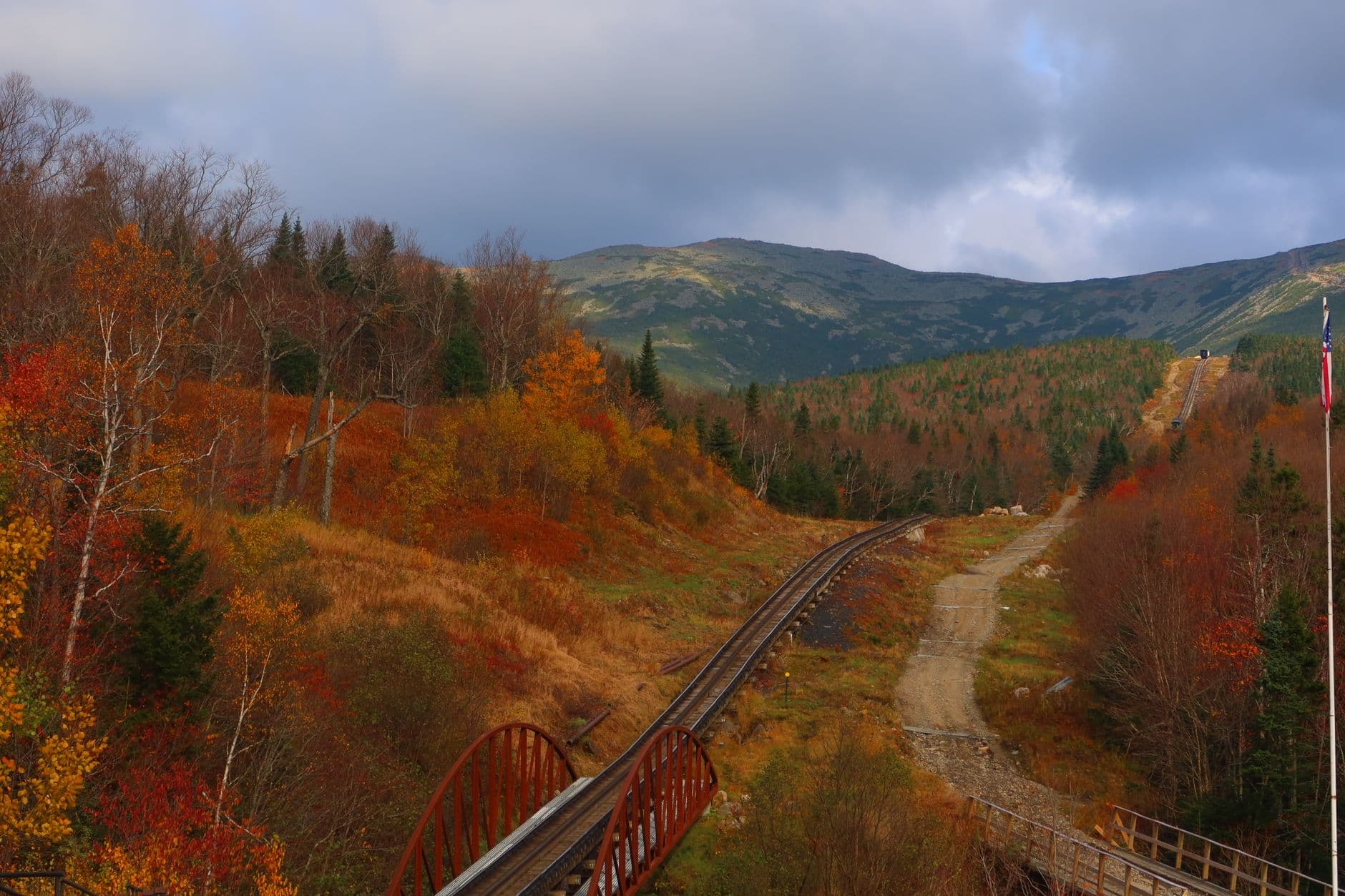
This is the day's centerpiece and its risk: check the Mount Washington Observatory forecast before committing to a full ascent, whether by trail, Auto Road, or Cog Railway. The reward at the summit—thin, cold air, wind that can knock you sideways, layered ridgelines fading into purple haze—is unlike anything else in the Northeast, but the mountain does not forgive complacency about weather. For couples, the Cog Railway offers a weather-safer, still-thrilling way to reach 6,288 feet without the physical toll of a full trail ascent, leaving more energy for the evening.

Mount Washington
Photo by Austin Sullivan on Pexels
If conditions allow a summit sunrise or clear midday visit, the summit cairn framed against layered ridgelines or a cloud inversion is the shot worth the effort; otherwise the Lakes of the Clouds plateau offers dramatic alpine scenery at lower risk.
Summit access via Auto Road or Cog Railway is far more accessible than trail hiking, though the summit itself has uneven terrain and no paved paths.
Optional detour: Sabbaday Falls overlookNot applicable today—reserve Kancamagus stops for Day 3
N/A Skip if: Save Kancamagus waterfalls for tomorrow to avoid cramming two heavy outdoor days together.
If it rains: If the summit forecast looks unstable, descend the ambition and instead spend the day exploring Crawford Notch's lower-elevation views and waterfalls, which intensify dramatically and beautifully in rain rather than becoming dangerous, unlike the summit itself.

Rise early to catch Crawford Notch in its quietest hour, the Saco River loud against smooth boulders and the granite walls still shadowed from the night—a brief, grounding stop before the day's real ambition begins.

The afternoon belongs entirely to Mount Washington: whichever route you choose—trail, Auto Road, or Cog Railway—expect the temperature and wind to shift dramatically as you climb, and treat the summit with the respect its reputation demands, turning back without hesitation if weather closes in.

Descend in the late afternoon light, legs pleasantly tired and adrenaline still humming, and let the evening settle into an upscale, unhurried dinner back in North Conway or Lincoln—the kind of reward a summit day deserves.

Waterfalls, slow drives, farewell light

Day 3: Forest Canopy and Hidden Water

A lighter closing day threading the Kancamagus Highway's forest and waterfalls, with roughly 2 miles of easy walking and a relaxed pace to unwind after yesterday's exertion.

Wear
Casual layers, waterproof footwear for waterfall-adjacent trails, a light jacket for shaded forest pullouts.
Budget
$130–170 for two, including lunch and a relaxed dinner
50 min driveA relaxed cross-region drive from the Mount Washington area, the road gradually narrowing into deep forest canopy
8:00 AM - 10:00 AM
Kancamagus Highway · morning · 120 min · Kancamagus Highway Loop

Arrive early while the pavement is still cool and the light filters low through birch and spruce—by 7:30-8am the Highway feels almost private, but by mid-morning pullouts fill with day-trippers. Stop at Sabbaday Falls, where the trail is short and the reward is an intimate, tucked-away cascade that feels made for two.

Kancamagus Highway
United States. Department of Agriculture. Office of Information / wikimedia (Public domain)
Sabbaday Falls' overlook is best photographed mid-morning when light angles down through the gorge without harsh overhead glare.
The Sabbaday Falls trail is short but includes uneven, sometimes wet footing; not wheelchair accessible.
20 min driveA slow, winding stretch of highway with the forest occasionally breaking open to reveal distant ridges
12:30 PM - 2:00 PM
Kancamagus Highway · afternoon · 90 min · Kancamagus Highway Loop

Continue east along the Highway to the scenic overlooks between mile 20 and 25, where the valley opens into wide, layered vistas—a gentler contrast to the morning's tighter waterfall trail. This stretch rewards patience: pull off, sit at the overlook, and let the ridgelines hold your attention without needing to rush to the next stop.

Kancamagus Highway
United States. Department of Agriculture. Office of Information / wikimedia (Public domain)
Early-to-mid afternoon light works well here, illuminating the valley without the flatness of midday overhead sun.
Overlooks are paved pullouts, relatively flat, though not formally wheelchair-designated.
Optional detour: Lower Falls areaAfter the mile 20–25 overlooks and before heading back toward lodging
A forest-framed waterfall with easy access, good for a final unhurried photo stop before the trip winds down. Skip if: If you're feeling waterfall fatigue after Sabbaday Falls, this is easy to skip without missing the day's core experience.
If it rains: The Kancamagus remains driveable in rain and its waterfalls actually swell and intensify, making it one of the more forgiving rainy-day options in the region—expect muted foliage and softened light rather than a ruined day.

Begin the final day early on the Kancamagus, when the forest is still and cool—the short walk to Sabbaday Falls delivers an intimate, secluded cascade that feels like a private discovery before the highway's other pullouts begin to fill.

The pace loosens further into the afternoon as you drift along the mile 20–25 overlooks, wide valley views opening up in contrast to the morning's tight gorge—an easy, contemplative stretch to close out the trip's physical demands.

Let the evening wind down gently—an unhurried dinner back in town, the day's forest air and waterfall mist still lingering in memory, a quiet, satisfying close to three days spent between granite walls and alpine wind.

Want to tweak this trip?

Our AI planner can customize this itinerary to your exact dates, interests, and travel style.

Customize This Itinerary
Good to Know

Restaurant details (hours, menus, availability) change frequently. Check current hours before visiting, especially in seasonal destinations.

Dietary compatibility tags are general guidance. If you have severe allergies, confirm directly with the restaurant.

Travel tips are general guidance, not professional safety advice. Check government advisories for latest information, especially regarding Mount Washington summit conditions.

All prices are approximate and may vary seasonally.
We use cookies to improve your experience and analyze site usage. Essential cookies are always active. You can customize your preferences or accept all cookies. Cookie Policy