3 DaysTeen Families5 Stops

White Mountains (North/South), New Hampshire

3-Day Itinerary for Teen Families

β€œNotch Light & Snowfall: 3 Days in the White Mountains”
Notch Light & Snowfall: 3 Days in the White Mountains

Snow settles into the granite folds of Franconia and Crawford Notch like powdered sugar on a held breath, and the whole range goes quiet enough to hear your own boots crunch. This is the White Mountains stripped of summer traffic β€” just cold light, steep rock walls, and three days built for a family that still wants a little adventure between hot chocolate breaks.

At a Glance

Climate & Weather
Expect harsh winter conditions: daytime highs often in the teens-to-30s Fahrenheit, heavy snow accumulation (70+ cm monthly Jan–Mar), and short daylight hours (sunset around 4:15–4:30 PM). Pack thermal base layers, waterproof insulated boots, hats, gloves, and a windproof outer shell β€” wind chill on notch roads and overlooks can be severe even when it's calm in town.
Getting Around
A car is essential β€” distances between notches run 30–60 minutes and public transit is virtually nonexistent in winter. Snow tires or all-season tires with good tread are strongly recommended; allow extra time on winding notch roads and check NH DOT road conditions each morning before setting out.
Budget
Budget roughly $120–180/day per family for meals and light activities (parking, hot drinks, one attraction fee); winter significantly reduces paid attraction costs since many trails and overlooks are free roadside stops.
Safety
Mount Washington and other high peaks are genuinely dangerous in winter due to extreme wind and whiteout conditions β€” this itinerary keeps teens at valley-floor and roadside viewpoints rather than summit attempts. Notch roads (Franconia, Crawford, Kancamagus) can turn icy fast; drive slowly, keep headlights on, and carry an emergency kit (blanket, snacks, water, ice scraper) in the car. Black bears are dormant this season, so wildlife risk is minimal.
Connectivity
Cell coverage is decent in North Conway, Lincoln, and along main routes (302, 3, 112) but drops out in notch interiors and higher elevations β€” download offline maps before heading into Franconia or Crawford Notch. Most lodges and cafes offer WiFi; don't count on signal at trailhead pullouts.
Local Tips
Arrive at scenic pullouts before 9 AM β€” winter light is low and gold much longer in the morning, and you'll often have iconic viewpoints entirely to yourselves. Many restaurants and shops in smaller notch-adjacent towns reduce hours or close weekdays November–April, so call ahead; North Conway and Lincoln stay the most reliably open. Let teens navigate one stop's photo composition or trail choice each day β€” it's a small autonomy win that keeps everyone engaged in the cold.

Highlights

  • Empty-feeling Franconia Notch pullouts with frost-rimmed Profile Lake
  • Snow-hushed drive through Crawford Notch's cliff-lined pass
  • Kancamagus Highway's forest tunnel dusted in white
  • Waterfall viewpoints half-frozen into blue-white sculpture
  • Golden-hour granite walls glowing pink at Cannon Mountain's base
  • Teen-friendly pockets of independence at scenic overlooks
  • Cozy lodge-style dining after a day in the cold

Day-by-Day Plan

Arrival & Easy Alpine Views

Day 1: Settling Into the Notch

A gentle half-day drive-and-stop introduction to Franconia Notch with under 1.5 miles of easy walking, easing everyone into cold-weather pacing.

Wear
Insulated waterproof boots, thermal base layers, windproof jacket, wool hat and gloves β€” most time is spent stepping out of a warm car into open, windy overlooks.
Budget
$90–130 for the day (lunch, hot drinks, minor parking fees)
9:30 AM - 11:30 AM
Franconia Notch Β· morning Β· 120 min Β· Franconia Notch & The Flume

The pass opens like a slow exhale between two granite shoulders, their walls dusted white and streaked with dark seams of exposed rock. Arrive by 9:30 and the Profile Lake pullout is yours alone β€” no cars threading the parkway yet, just the hush of snow-muffled air and the ghost-shape of the old Cannon cliffs looming overhead. Let teens pick which pullout to stop at longer; the drive rewards a little wandering, and each turn reveals a new angle on the ridge.

Franconia Notch
Paleontological Research Institution (Ithaca, N.Y.) Columbia University / wikimedia (Public domain)
Shoot the Cannon Mountain cliffs from the parkway pullouts in late morning, when low winter sun rakes sideways across the rock face and throws every crevice into relief.
Pullouts are roadside and paved, but can be icy β€” flat_path is limited, so wear grippy boots and expect some uneven, snow-packed ground.
If it rains: The Parkway stays open and drivable in light rain or snow, though views dim β€” if visibility drops sharply, use the extra time for a slower, more scenic drive with fewer stops rather than pushing through poor conditions.

Ease into the trip with a late-morning start β€” no alarm-clock urgency on day one. The drive into Franconia Notch feels like entering a hushed cathedral of stone, snow softening every hard edge and the road nearly empty this time of year. Rotate through two or three pullouts, letting the cold air and big views do the work of resetting everyone's internal clock after travel.

With the notch explored at an easy pace, spend the early afternoon settling into lodging and exploring on foot near town β€” a low-key wander through North Conway or Lincoln's main street, popping into a shop or two, no pressure to check off more sights today.

Dinner tonight is about warmth and simplicity β€” find a casual spot in whichever town you're based, order something hearty, and let the day's cold-air alertness fade into an early, easy night. Tomorrow's day is longer, so an 8 PM wind-down works in everyone's favor.

Notch Drama & Respectful Distance

Day 2: Crawford's Cliffs and the Mountain That Makes Weather

A moderate day driving through Crawford Notch with roadside stops totaling under 2 miles of walking, viewing Mount Washington from safe valley vantage points rather than ascending.

Wear
Full winter layering system β€” thermal base, fleece mid-layer, waterproof shell, insulated snow boots, plus hand warmers for extended outdoor viewing time.
Budget
$100–150 for the day (lunch, hot drinks, possible Cog Railway viewing fee if operating)
45 min drive β€” A quiet 45-minute drive south on Route 302, the road tracing the valley floor with glimpses of frozen streams flashing between the trees.
9:00 AM - 9:45 AM
Crawford Notch Β· morning Β· 45 min Β· Crawford Notch & Mount Washington

The road narrows and the mountains close ranks, granite walls rising steeply on either side while the Saco River β€” mostly ice-locked now, with dark open water threading through β€” mutters beneath snow-draped boulders. Get here by 9 AM and the overlook near Crawford Depot is silent except for wind and running water; by midday, even in winter's low season, a handful of other cars will have found it too. This is a short, high-impact stop β€” good for restless energy before a longer day ahead.

Crawford Notch
Shipp, John Edgar Dawson, 1858- [from old catalog] / wikimedia (Public domain)
The Saco Lake viewpoint offers a reflection shot of Mount Washington's flank when skies are clear β€” best in the flat light of mid-morning before haze builds.
Roadside pulloffs are accessible by car but uneven and often icy underfoot; sturdy boots with traction are essential.
15 min drive β€” A short, scenic 15-minute drive further along 302 toward the base area, mountain looming larger with every mile.
10:30 AM - 1:00 PM
Mount Washington Β· midday Β· 150 min Β· Crawford Notch & Mount Washington

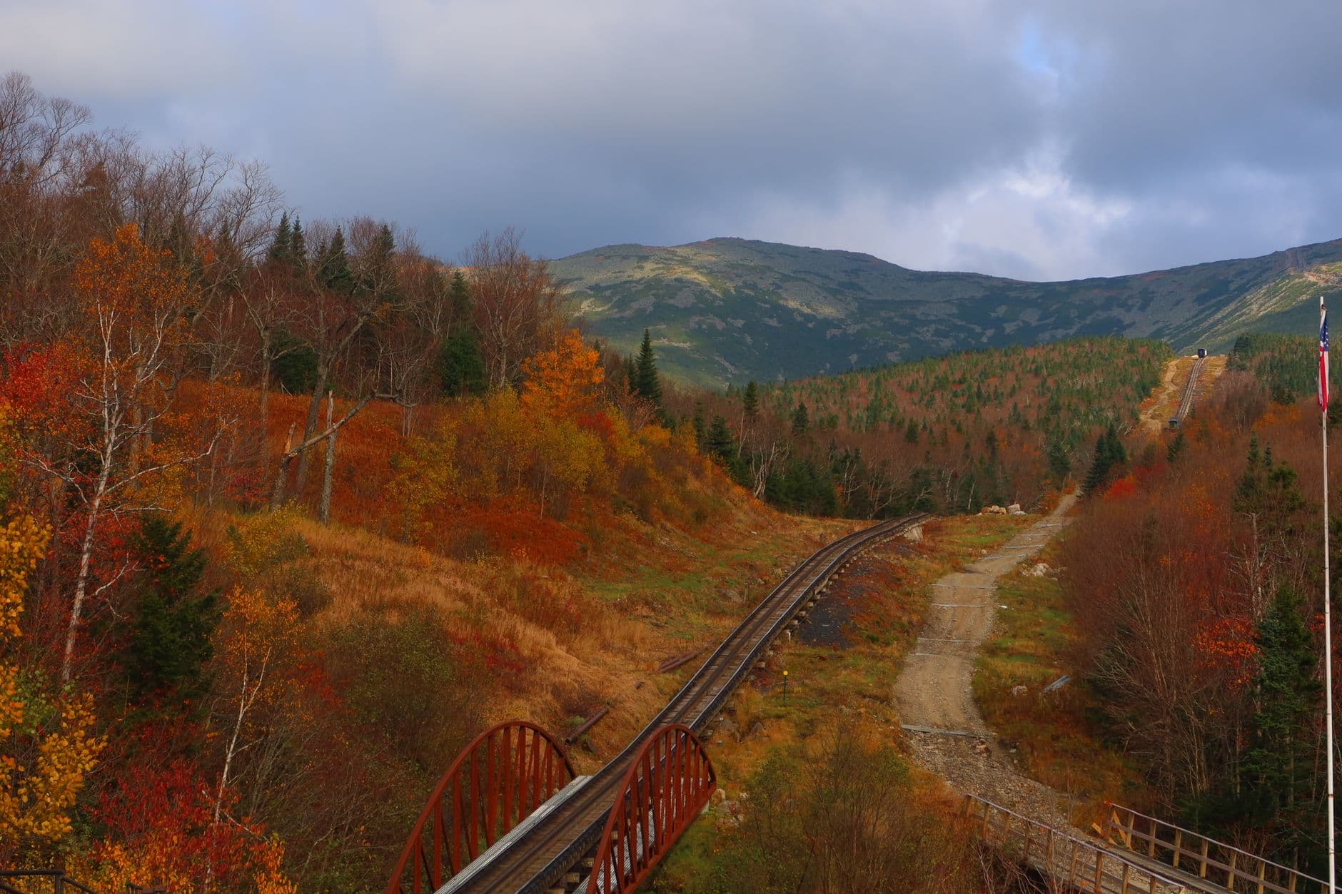
This isn't a summit day β€” not in winter, not with teens in tow β€” but the mountain's presence dominates the valley regardless, a pale, wind-scoured hulk that seems to generate its own weather. Viewing from safe lower elevations lets you appreciate the scale without the real danger the upper mountain poses this time of year; if the Cog Railway is running its limited winter schedule, it's a genuinely thrilling weather-safe way to get closer to the summit's drama. Otherwise, this block is about respectful distance β€” a valley-floor pause to take in New England's highest and most temperamental peak, with plenty of teen-friendly photo ops and storytelling about the mountain's infamous winds.

Mount Washington
Photo by Austin Sullivan on Pexels
Shoot the summit cone from the base area in early afternoon when clouds tend to lift briefly β€” patience pays off here, and a long lens helps capture the wind-scoured ridgeline.
Base-area viewing is roadside and manageable, but higher trail access is closed or hazardous in winter β€” do not attempt unmarked trails.
Optional detour: Mount Washington β€” After Crawford Notch and before returning to lodging
Even distant, wind-blasted views of the Northeast's highest peak are a genuine highlight and a great backdrop for family photos and mountain-lore storytelling. Skip if: Skip any thought of trail access or summit approach entirely in winter β€” conditions above treeline are lethal, and this stop should remain strictly a valley-floor viewing experience.
If it rains: If snow or rain intensifies, the notch drive remains passable at reduced speed β€” mist and swollen falls can actually make Crawford Notch more dramatic; if visibility becomes dangerous, retreat toward North Conway or Lincoln and treat the day as a driving-and-cafΓ© day instead.

Morning starts with purpose today β€” an early departure gets you to Crawford Notch while it's still hushed and near-empty, the road narrowing into a corridor of stone and snow-heavy pine. The Saco River's partial ice cover and the sheer scale of the cliffs make for an immediately gripping start to the day, a sharper contrast to yesterday's gentler pace.

By midday, the focus shifts toward Mount Washington itself β€” not as a hike, but as spectacle. Viewing the peak from respectful valley distance, perhaps catching the Cog Railway if it's running, gives teens the mountain's mythology (deadliest weather in North America, hurricane-force winds) without any of the real risk. This is a good stretch for letting teens ask questions, take the lead on photo composition, and absorb a little natural history.

Head back toward town as the light fails β€” winter sunsets arrive fast here, often by 4:15 PM β€” and settle into a warm, casual dinner. Legs will be tired from cold-weather walking even without long trails, so an unhurried meal and an early night suit the day's rhythm well.

Scenic Drive & Waterfall Wonder

Day 3: Forest Tunnel and Frozen Falls

A moderate final day cruising the Kancamagus Highway with short walks to waterfall viewpoints, totaling roughly 2 miles on packed or icy trails.

Wear
Insulated waterproof boots with solid tread (short walks to falls can be icy), warm layers, and a hat β€” wind picks up at higher pullouts along the Kanc.
Budget
$80–120 for the day (lunch, hot drinks, minor snacks)
50 min drive β€” A 50-minute drive west connecting from lodging into the start of the Kancamagus corridor, the road gradually climbing into thicker forest.
9:00 AM - 11:00 AM
Kancamagus Highway Β· morning Β· 120 min Β· Kancamagus Highway Loop

The Kanc in winter feels like driving through a hushed white tunnel β€” birch and spruce heavy with snow, the road clear but flanked by drifts, and almost no other cars this early. Arrive by 9 AM for a nearly private drive; by midday even winter's light traffic picks up around the popular pullouts. Stop at two or three overlooks and let teens choose which one to linger at longer β€” the valley vistas between miles 20–25 are the payoff shot, wide and layered with distant ridgelines fading into blue-white haze.

Kancamagus Highway
United States. Department of Agriculture. Office of Information / wikimedia (Public domain)
The mile 20–25 overlooks work best in mid-morning light, when the sun is high enough to illuminate the valley floor without harsh shadows across the ridgelines.
Pullouts are paved but often snow-packed or icy; use caution stepping out, and stick to cleared areas near the car.
10 min drive β€” A short 10-minute hop further along the highway, the road curving gently through denser forest toward the falls pullout.
11:15 AM - 12:30 PM
Kancamagus Highway Β· midday Β· 75 min Β· Kancamagus Highway Loop

Continue toward the Sabbaday Falls pullout, where a short, snow-packed path leads to a waterfall half-transformed into a sculpture of blue-white ice with just a ribbon of dark water still moving through the center. It's a striking, almost sci-fi sight β€” the kind of thing that gets phones out immediately β€” and short enough that even reluctant cold-weather walkers won't complain. This is a good spot to let teens set the pace and choose their own vantage points for photos.

Kancamagus Highway
United States. Department of Agriculture. Office of Information / wikimedia (Public domain)
Shoot the falls straight-on in flat midday light β€” the ice formations read best without harsh shadows, and a slight polarizing filter cuts glare off the ice.
The path to the falls overlook is short but can be icy and uneven; not wheelchair accessible in winter conditions β€” sturdy footwear with traction is a must.
Optional detour: Kancamagus Highway β€” Between the morning overlooks and the Sabbaday Falls stop
An additional pullout near the Lower Falls area offers forest-canopy framing of the river that's a nice contrast to the open valley vistas earlier in the drive. Skip if: If the morning is running long or the group's cold tolerance is wearing thin, this stop is easy to skip without losing the day's main highlights.
If it rains: If rain or heavy snow reduces visibility along the highway, the drive itself remains passable at reduced speed with headlights on; consider shortening the number of pullout stops and prioritizing Sabbaday Falls, which is dramatic in nearly any weather, then heading back to town early for a relaxed final afternoon.

The last full day starts with the Kancamagus at its quietest β€” winter strips away the leaf-peeper crowds entirely, leaving just forest, snow, and the occasional plume of exhaust from a distant car. The drive itself is the experience here: wide valley views, snow-laden trees pressing close to the road, and a sense of having the whole national forest to yourselves.

Midday shifts to a shorter, more textural stop β€” the short walk to Sabbaday Falls, where ice has reshaped the waterfall into something otherworldly. It's a manageable walk even in cold boots, and a satisfying way to close out the trip's outdoor stops with something visually striking and easy to swap camera duties on with teens.

Head back into town for a final relaxed dinner β€” nothing rushed, just a chance to decompress after three days of cold air and big views. Pack the car for tomorrow's departure tonight if possible, so the morning stays unhurried and the trip ends on the same easy note it began.

Want to tweak this trip?

Our AI planner can customize this itinerary to your exact dates, interests, and travel style.

Customize This Itinerary
Good to Know

Restaurant details (hours, menus, availability) change frequently, especially in winter when many establishments reduce hours or close entirely. Check current hours before visiting.

Dietary compatibility tags are general guidance. If you have severe allergies, confirm directly with the restaurant.

Travel tips are general guidance, not professional safety advice. Mount Washington and high-elevation terrain pose serious risks in winter β€” check current conditions and government advisories before any high-elevation activity.

All prices are approximate and may vary seasonally.
We use cookies to improve your experience and analyze site usage. Essential cookies are always active. You can customize your preferences or accept all cookies. Cookie Policy