3 DaysTeen Families6 Stops

Blue Ridge Highlands (Bristol, Abingdon), Virginia

3-Day Itinerary for Teen Families

ā€œRidgeline & Rail-Trail: 3 Days in the Blue Ridge Highlandsā€

Ridgeline & Rail-Trail: 3 Days in the Blue Ridge Highlands

Wild ponies graze windswept meadows below Virginia's highest peak, while a 34-mile rail-trail unspools through hemlock shade and creek crossings below. This is a highlands trip built for families with teens who want real adventure — hiking, biking, and open sky — without losing the casual, small-town evenings that make the region feel like home.

At a Glance

Climate & Weather
Summer days run mild-to-warm in the mid-70s°F at elevation, cooler than the valley floor, with afternoon thunderstorms a real possibility — pack a light rain shell, layers for early morning chill on the mountain, and sturdy hiking or biking shoes. Sun protection matters in open meadows where there's little shade.
Getting Around
A car is essential for reaching Grayson Highlands and the Creeper Trail access points; trailheads and shuttle services connect the trail corridor, and many outfitters in Damascus offer bike rentals and shuttle-back service.
Budget
Budget roughly $60-100/day per person for a teen family, covering casual meals, bike rental or shuttle fees, and trail snacks; state park and trail access itself is largely free.
Safety
Very safe overall; the main hazards are weather-related — lightning risk on exposed summits and slick trail sections after rain. Keep a respectful distance from wild ponies at Grayson Highlands and never feed them, both for safety and their wellbeing.
Connectivity
Cell coverage is spotty to nonexistent on the mountain and along wooded sections of the Creeper Trail — download maps and let someone know your plan before heading out. Coverage returns reliably in Damascus and other trail towns.
Local Tips
Start on the mountain by 7:30-8am in summer — both the ponies and the parking lots get crowded fast, and afternoon storms build reliably by early afternoon. Book bike shuttles in Damascus a day ahead in peak summer, and expect small-town kitchens to wind down by 8-9pm, so plan dinner accordingly.

Highlights

  • Wild ponies grazing free on Wilburn Ridge at dawn
  • Standing on Virginia's highest point above the tree line
  • Coasting downhill for miles on the Virginia Creeper Trail
  • Trestle bridges and creek crossings through deep Appalachian green
  • Early-morning meadows with almost no one else around
  • Casual small-town evenings in Damascus and the trail corridor
  • Teen-friendly independence on bike sections and trail stretches

Day-by-Day Plan

Arrival & Wild Ponies

Day 1: First Light on Wilburn Ridge

A gentler arrival day centered on one unforgettable morning hike among wild ponies, with an easy afternoon to settle in — roughly 3 miles of walking total.

Wear
Layers for cool morning mountain air warming to summer heat by midday, sturdy hiking shoes, sun hat, and a light rain shell just in case.
Budget
$70-90 for the family (trail snacks, casual lunch, dinner)
7:30 AM - 9:30 AM
Grayson Highlands (wild ponies) Ā· morning Ā· 120 min Ā· Mount Rogers & Grayson Highlands

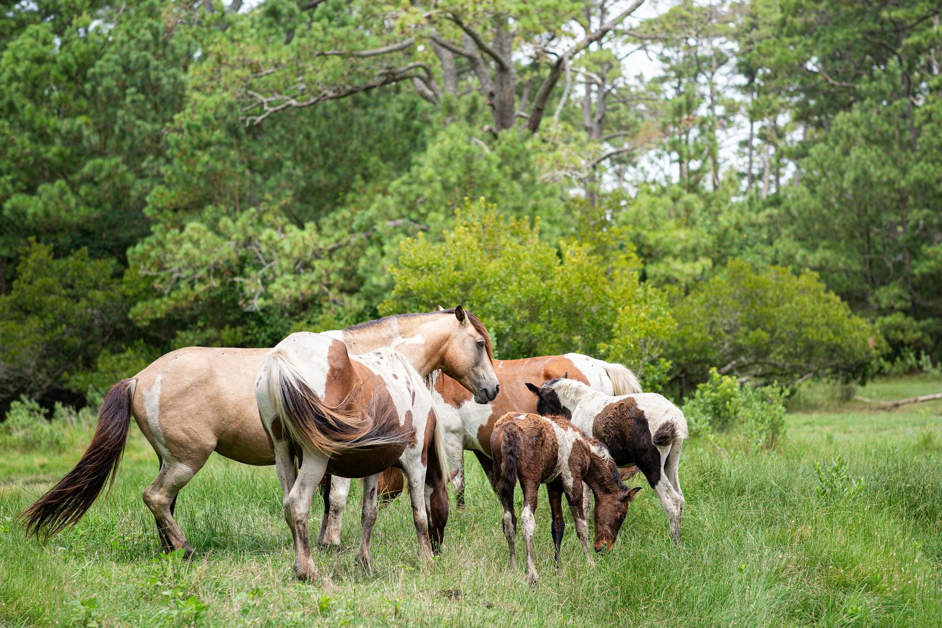
Arrive while the meadows are still cool and mist clings to the ridgelines — this is when the wild ponies are most active and the parking areas are still empty. Kids and teens alike light up at the first sighting: a shaggy pony grazing calmly against a backdrop of rolling highland grass and distant blue ridges. Keep a respectful distance and never feed them, but do let the moment stretch — this is the kind of encounter that doesn't need narration.

Grayson Highlands (wild ponies)
Boys in Bristol Photography / pexels (Pexels License)
Head toward the Stamped Ground Trail or lower meadows for pony sightings with the ridge line as backdrop; soft early light between 7:30-8:30am is best before haze sets in.
Trails here are uneven and unpaved with no wheelchair access; benches are sparse, so plan rest stops accordingly for younger walkers.
15 min walk — A short walk along connecting trail from the pony meadows, gently climbing as the grass gives way to forest.
9:45 AM - 12:00 PM
Mount Rogers Ā· midday Ā· 135 min Ā· Mount Rogers & Grayson Highlands

Rather than the full 8-hour summit push, take the shorter approach from Grayson Highlands into the lower reaches of the Mount Rogers approach trail — enough to feel the spruce-fir forest close in and catch a taste of the wind-scoured high country without exhausting younger legs. Teens will appreciate the sense of scale as the trees thin and views start opening toward Tennessee.

Mount Rogers
Famartin / wikimedia (CC BY-SA 4.0)
The point where the tree line breaks near Wilburn Ridge offers the best mid-morning shot, with layered ridges fading into the distance.
Not wheelchair accessible; the trail is rocky and moderately steep in sections — turn back at any point if kids tire.
Optional detour: Virginia Creeper Trail — After Mount Rogers and before evening rest
If energy allows, a short easy stretch near the trailhead offers a preview of tomorrow's ride with minimal commitment. Skip if: After a full highland morning, most teen families will want rest rather than another trail — save it fresh for Day 2.
If it rains: If storms roll in, descend from the highlands immediately (lightning risk on exposed terrain) and treat the afternoon as a rest day back at lodging, revisiting the ponies on a clearer morning if your schedule allows.

The day opens on Wilburn Ridge in gray-gold light, the kind of cool mountain air that makes breath visible for the first hour. Ponies drift across the meadows as if choreographed, unbothered by the small clusters of early hikers. It's unhurried, wide-open, and exactly the right register for a first day — no rush, just space to breathe and look.

By midday, the group eases into the edge of the Mount Rogers approach, trading meadow grass for shaded spruce-fir forest. It's enough exertion to feel earned without tipping into exhaustion — a taste of the mountain's scale before the legs get a proper rest.

Evening settles in slow, small-town style. Dinner options run casual and unhurried in the trail corridor towns, with kitchens typically closing by 8-9pm — plan to eat on the earlier side. Let the day's pony encounters replay over the meal; there's no need to fill the evening with more.

Mountain Ascent

Day 2: Above the Tree Line

A more ambitious day pushing further into the Mount Rogers high country, balancing intensity with plenty of pause for views — approximately 4-5 miles of hiking.

Wear
Warm layers for the exposed summit approach (temperatures drop noticeably above tree line even in summer), waterproof shell, broken-in hiking boots, and a hat for sun and wind.
Budget
$60-80 for the family (snacks, lunch, dinner)
7:00 AM - 12:00 PM
Mount Rogers Ā· morning Ā· 300 min Ā· Mount Rogers & Grayson Highlands

This is the day's centerpiece — a fuller push toward Virginia's highest point via the Grayson Highlands approach. Arrive by 7am and the trail is nearly silent, just wind moving through rhododendron thickets and the occasional flash of pink bloom if you're here in late June. The summit itself is quiet, wind-scoured, and unassuming — no dramatic marker, just a cairn and 360 degrees of ridge after ridge fading into haze. Teens tend to find real pride in this one; it's a legitimate accomplishment, not a paved overlook.

Mount Rogers
Famartin / wikimedia (CC BY-SA 4.0)
The summit cairn with northwestward ridge views is the money shot — aim for mid-morning before clouds build, and check the rhododendron thickets near Wilburn Ridge if blooming.
Strenuous, unpaved, and not wheelchair accessible; this is the most physically demanding stop of the trip — turn back if anyone in the group is struggling, especially before storm buildup in early afternoon.
20 min walk — A gradual descent back through forest and meadow, legs tired but the terrain easing with every step.
1:00 PM - 2:30 PM
Grayson Highlands (wild ponies) Ā· afternoon Ā· 90 min Ā· Mount Rogers & Grayson Highlands

Looping back through the highlands on the descent, the pace slows considerably. Afternoon light flattens the meadows into soft gold, and if the ponies have moved to new grazing ground, it's a good excuse to explore a different stretch of Wilburn Ridge than this morning. This is intentionally lower-intensity — a decompression stop after the summit push.

Grayson Highlands (wild ponies)
Boys in Bristol Photography / pexels (Pexels License)
Afternoon light around 1-2pm is flatter than dawn but still workable for wide meadow shots with ponies grazing in the mid-distance.
Uneven terrain throughout; benches are sparse, so this is a good spot to sit directly on rock outcrops or grass for a real break.
Optional detour: Virginia Creeper Trail — After Grayson Highlands afternoon stop and before evening
A short, flat preview walk near a trailhead can ease legs into tomorrow's rail-trail plan and offer a change of scenery. Skip if: After a demanding summit day, most families will want to head to lodging and rest rather than add another trail stop.
If it rains: Thunderstorms are a real risk at elevation — if weather turns, descend from the summit immediately and reroute the day toward lower Grayson Highlands trails or head back to town early; do not linger on exposed rock in a storm.

The trail up toward Mount Rogers starts in near-total quiet, just boots on rock and wind combing through spruce-fir. As the trees thin, the sky opens into something genuinely dramatic — ridge after ridge stacking into the haze, no crowds, no railings, just scale. Reaching the summit cairn feels less like a photo opportunity and more like an actual accomplishment, which lands well with teens looking for something real.

The descent loops back through the highlands at a much gentler pace, legs tired but grateful for softer ground. Afternoon light turns the meadows warm and hazy, and any ponies still grazing nearby make for an easy, low-key finish to a physically demanding day.

Dinner tonight should be simple and filling — legs earned it. Small-town kitchens in the area tend to wind down by 8-9pm, so aim for an earlier seating and let the evening stay quiet; tomorrow's rail-trail day calls for fresh legs.

Rail-Trail Adventure

Day 3: Downhill Through the Green

A lighter, rolling day biking a scenic stretch of the Virginia Creeper Trail — mostly flat-to-downhill terrain, roughly 8-12 miles by bike with minimal walking.

Wear
Breathable athletic wear, closed-toe shoes for biking, a light jacket for the cooler morning descent, and sunscreen for open meadow stretches.
Budget
$80-120 for the family (bike rental/shuttle, casual meals)
8:00 AM - 11:30 AM
Virginia Creeper Trail Ā· morning Ā· 210 min Ā· Virginia Creeper Trail Corridor

Book a shuttle-and-bike combo through a Damascus outfitter and start high, letting gravity do most of the work as the trail drops steadily through hemlock groves and open farmland. The trestle bridges are the highlight — wide wooden crossings suspended over Laurel Creek with views stretching down the valley. Arrive at the upper trailhead by 8am and the trail feels almost private; by mid-morning, cyclists and hikers fill in fast.

Virginia Creeper Trail
Kessler, Winifred B United States. Forest Service. Alaska Region / wikimedia (Public domain)
The restored trestles between the upper trail and Damascus are the standout shot — best light comes mid-morning when sun angles through the valley rather than glaring off the wood.
Not wheelchair accessible along most of the route; flatter sections near Abingdon are more manageable for anyone needing easier terrain, though this itinerary uses the more scenic upper stretch.
30 min bike — A gentle, mostly downhill roll through open meadow and creekside forest, the trail town's rooftops finally coming into view.
11:30 AM - 1:00 PM
Virginia Creeper Trail Ā· midday Ā· 90 min Ā· Virginia Creeper Trail Corridor

The final approach into Damascus flattens out, giving tired legs an easy coast alongside Laurel Creek before the trail spills into town. This last stretch is a good moment for teens to ride ahead a little and set their own pace — a small taste of independence within a clearly bounded, safe corridor.

Virginia Creeper Trail
Kessler, Winifred B United States. Forest Service. Alaska Region / wikimedia (Public domain)
Whitetop's open meadow stretch, if included in your route, offers wide ridge-line views best captured before midday haze sets in.
Terrain remains unpaved and uneven throughout; younger or less experienced riders should stick to the flatter lower sections.
Optional detour: Mount Rogers — Not applicable today — save for Day 2 pacing
N/A — this cluster is not revisited today to avoid backtracking across the destination. Skip if: Combining a strenuous summit hike with a full biking day would exceed reasonable pacing and walking limits for teens.
If it rains: If rain sets in, the trail becomes slick and mud-heavy — consider shortening the ride to the flatter, lower sections near town, or postpone biking and spend the time exploring Damascus's shops and casual eateries instead.

The morning starts with a shuttle ride up into cooler air, then a long, easy coast downhill as the trail drops through hemlock shade and past creek crossings. Trestle bridges arrive like punctuation marks — wide, open, and worth slowing down for. It's the kind of morning that feels like play rather than exertion, which makes it land well after two more demanding days.

As the trail nears Damascus, the terrain flattens and the pace relaxes further. Teens get room to ride slightly ahead within sight, a small taste of independence that tends to matter more than it sounds. The town arrives gradually — rooftops, then storefronts, then the low hum of a small trail town at midday.

With the ride complete, the rest of the evening is left open for winding down at a relaxed pace — small-town kitchens here tend to close early, so plan dinner on the earlier side and let the day's mileage settle in before an early night.

Want to tweak this trip?

Our AI planner can customize this itinerary to your exact dates, interests, and travel style.

Customize This Itinerary
Good to Know

Restaurant details (hours, menus, availability) change frequently. Check current hours before visiting, especially in seasonal destinations.

Dietary compatibility tags are general guidance. If you have severe allergies, confirm directly with the restaurant.

Travel tips are general guidance, not professional safety advice. Check government advisories for latest information.

All prices are approximate and may vary seasonally.
We use cookies to improve your experience and analyze site usage. Essential cookies are always active. You can customize your preferences or accept all cookies. Cookie Policy