2 DaysCouples5 Stops

Rocky Mountain NP (Trail Ridge Road), Colorado

2-Day Itinerary for Couples

Sky Road & Still Water: Two Days Above the Clouds

Sky Road & Still Water: Two Days Above the Clouds

Above 11,000 feet, the air thins to a whisper and the horizon unspools in every direction — this is a landscape built for slowing down together. Over two days, the road climbs from pine-shadowed lakes to windswept tundra, pairing sweeping vistas with the kind of quiet that makes couples stop talking just to listen.

At a Glance

Climate & Weather
Expect mild days near 45°F at elevation with clear skies most mornings, but afternoon thunderstorms are common July–September and snow is possible above 11,000 feet any month. Pack layers — a waterproof jacket, warm mid-layer, sun hat, and sunscreen are non-negotiable even in summer.
Getting Around
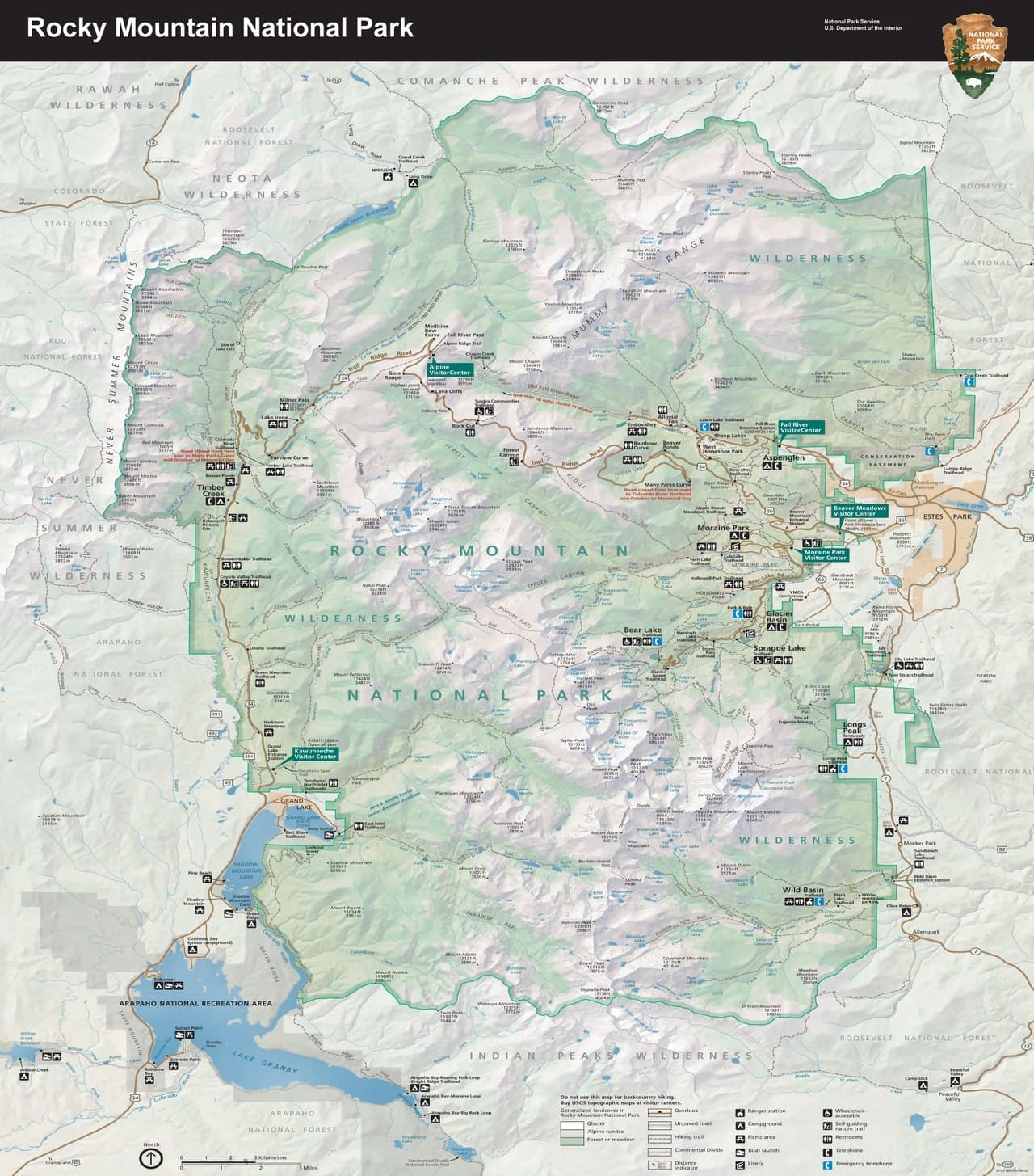
A personal vehicle is essential; there's no public transit on Trail Ridge Road itself. The 48-mile byway connects Estes Park (east) and Grand Lake (west) via US-34, with pullouts and visitor centers spaced along the route — plan for slow, scenic driving rather than point-to-point speed.
Budget
Budget roughly $120–180 per day per couple for meals, park entrance/timed-entry fees, and one splurge dinner in Estes Park.
Safety
The thin air at altitude (about 30% less oxygen) can bring on lightheadedness or nausea; move slowly, hydrate constantly, and descend if symptoms appear. Afternoon lightning is the real hazard above treeline, so plan high-elevation stops for morning and be off exposed ridges by early afternoon. Keep a respectful distance from elk and marmots — they're common but still wild.
Connectivity
Cell service is spotty to nonexistent above treeline and inside most of the park; download offline maps and let each other know your rough itinerary before losing signal. Estes Park and Grand Lake have reliable WiFi and cell coverage.
Local Tips
Arrive at Trail Ridge Road viewpoints by 7:30–8am for near-solitude and the softest light; by 10am, parking lots fill and the crowds thicken. Book a timed-entry permit in advance for summer visits — this park requires reservations during peak season. Reserve dinner in Estes Park a day or two ahead, especially for anything with a view.

Highlights

  • Sunrise light hitting the Continental Divide from Rock Cut
  • A hairpin curve at 12,000 feet with your breath visible in July
  • Still-water reflections of Hallett Peak on Bear Lake at dawn
  • An easy boardwalk loop around Sprague Lake for golden hour
  • Standing at 11,796 feet inside the Alpine Visitor Center
  • Thin-air quiet on the tundra with only a marmot's whistle for company

Day-by-Day Plan

Arrival & Alpine Lakes

Day 1: Lakeside Stillness and First Light

A gentle first day centered on two accessible lake walks, roughly 2.5 miles total, with low physical demand to ease into altitude.

Wear
Layered clothing — a light fleece and waterproof shell over a breathable base layer, sturdy walking shoes, sun hat, and sunglasses for glare off the water.
Budget
$90–130 for the couple, including park entry and a relaxed dinner in Estes Park.
7:30 AM - 9:30 AM
Bear Lake · morning · 120 min · Bear Lake & Emerald Lake Corridor

Arrive while the lake is still glass-flat and Hallett Peak's reflection hasn't yet been broken by wind or foot traffic. The lake loop is short and unhurried — just enough elevation gain to feel the air thin, but nothing strenuous, leaving plenty of energy for conversation and photographs. By 9am the parking lot fills fast, so this early window is the couple's best shot at having the shoreline nearly to themselves.

Bear Lake
inkknife_2000 (7.5 million views +) / wikimedia (CC BY-SA 2.0)
Shoot the shoreline reflection of Hallett Peak in the first hour after sunrise, before wind ripples the water.
Trail is unpaved and uneven in places, not fully wheelchair accessible, but manageable at a relaxed pace.
15 min driveA short descent on the park road, pines closing in around the car after the openness of Bear Lake.
10:15 AM - 11:15 AM
Sprague Lake · midday · 60 min · Sprague Lake Loop

A short drive down in elevation brings a softer, easier loop — a half-mile boardwalk that circles the lake with Flattop and Hallett Peak looming behind still water. This is the low-key counterpart to the morning's hike, ideal for couples who want scenery without more climbing, and the boardwalk means wandering hand-in-hand without watching your footing.

Sprague Lake
U.S. National Park Service, restoration/cleanup by National Park Maps (https://npmaps.com) / wikimedia (Public domain)
Midpoint of the boardwalk facing Flattop and Hallett Peak is the classic postcard shot — good light most of the morning.
Fully wheelchair accessible boardwalk loop with frequent benches, the most accessible stop of the trip.
Optional detour: Sky Pond TrailAfter Bear Lake and before Sprague Lake
For couples craving a serious alpine challenge, this trail delivers turquoise glacial water and dramatic granite scenery unmatched elsewhere in the park. Skip if: At 8+ hours round-trip with intense exertion, it overwhelms a couples-paced, low-key first day and risks afternoon lightning exposure — better saved for a dedicated full day if attempted at all.
If it rains: If storms roll in, retreat to the car and head toward Estes Park early; the exposed alpine terrain around Bear Lake is dangerous in lightning, and shorter lake loops are safer than any higher trail in bad weather.

The day opens gently at Bear Lake, arriving early enough that the water holds its mirror-stillness and the only sound is wind moving through lodgepole pine. Couples can take the full loop unhurried, pausing often — this is a day built for lingering, not covering ground.

After a short, scenic drop in elevation, the pace eases further at Sprague Lake, where a flat boardwalk circles calm water beneath the same peaks seen earlier from a different angle. It's a soft landing for a first day, giving both of you time to adjust to the altitude before the more demanding tundra exploration of day two.

As afternoon light softens over Estes Park, settle into the town's Victorian-era main street for an intimate dinner — reserve ahead, as summer evenings fill quickly. Wind down early; tomorrow's high-altitude drive rewards those who beat the sunrise crowds.

Alpine Tundra & Grandeur

Day 2: Into the Sky: Trail Ridge Road

A dramatic, higher-elevation day along Trail Ridge Road with about 1.5 miles of easy walking across three iconic viewpoints, moderate energy due to altitude.

Wear
Warm layers are essential even in July — expect near-45°F temperatures at elevation, biting wind, and possible sudden rain; bring a waterproof shell, gloves, and a warm hat.
Budget
$100–150 for the couple, including a splurge dinner back in Estes Park.
7:00 AM - 8:00 AM
Rock Cut · morning · 60 min · Trail Ridge Road Scenic Corridor

At 12,000 feet, the tundra stretches in every direction beneath a sky so blue it looks over-saturated. Arriving at dawn means the boardwalk is nearly empty and the light rakes low across the granite peaks of the Continental Divide — a rare, hushed moment before the midday crowds arrive between 10am and 3pm. The thin air makes even a leisurely stroll feel a little breathless, so take it slow and let the view do the work.
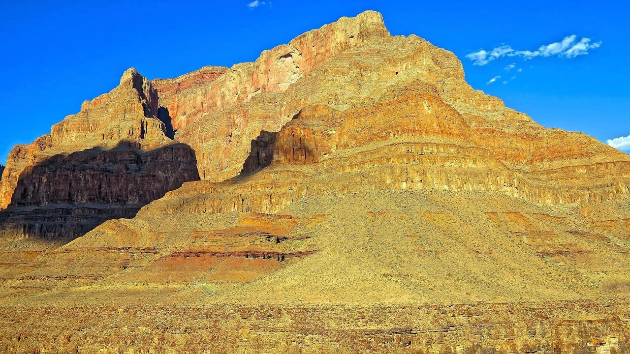
Rock Cut
Photo by nextvoyage on Pixabay
The main boardwalk overlook facing the Continental Divide is best in early morning light, when shadows carve deep relief into the peaks.
Flat boardwalk with frequent benches, fully accessible even at altitude.
20 min driveClimbing higher along the byway's curves, evergreen forest thinning into open tundra as the road narrows and views widen.
9:00 AM - 9:30 AM
Many Parks Curve · midday · 30 min · Trail Ridge Road Scenic Corridor

A hairpin curve delivers one of the most dramatic panoramas of the drive — the Continental Divide unfurling beyond Forest Canyon, with your breath visibly clouding the alpine air even in summer. It's a brief stop, but the kind that stops conversation entirely for a moment; couples often find this the most photographed five minutes of the whole trip.

Many Parks Curve
inkknife_2000 (7.5 million views +) / wikimedia (CC BY-SA 2.0)
Late-morning light works well here — try the north-facing overlook across Forest Canyon toward the Divide.
No paved path and no benches; footing is uneven, so sturdy shoes are recommended.
10 min driveA short climb further up the byway, past pullouts where marmots often sun themselves on roadside rocks.
10:00 AM - 10:45 AM
Alpine Visitor Center · afternoon · 45 min · Trail Ridge Road Scenic Corridor

The highest visitor center of its kind sits at 11,796 feet, where indoor exhibits offer a welcome respite from the wind and a chance to warm up over coffee at the on-site cafe. It's also the practical last stop before afternoon thunderstorms typically build — plan to be here by late morning and begin descending shortly after, since storms roll in with little warning at this elevation.

Alpine Visitor Center
inkknife_2000 (7.5 million views +) / wikimedia (CC BY-SA 2.0)
The west-facing overlook is stunning at sunset, but for a morning visit, capture the tundra boardwalk section with soft, even light.
Fully wheelchair accessible with flat paths and frequent benches — the most accommodating stop at this elevation.
Breakfast
Trail Ridge Cafe $
Cafe/Coffee · At Alpine Visitor Center
A simple, warming stop for coffee and light bites at nearly 12,000 feet — worth it just for the novelty of breakfast this high up.
If it rains: If fog or thunderstorms move in, retreat immediately to the Alpine Visitor Center for indoor exhibits and the gift shop, or descend to lower elevations — Trail Ridge Road can close without warning in bad weather, so don't linger at exposed overlooks once storms build.

The day begins in near-darkness with a drive up into the clouds, arriving at Rock Cut just as the sun clears the peaks. The tundra here feels otherworldly — treeless, windswept, and utterly quiet except for the occasional pika call — and the early hour means you'll likely have the boardwalk to yourselves.

From there, the road curves higher still to Many Parks Curve, a brief but breathtaking pause before reaching the Alpine Visitor Center, the literal high point of the trip at nearly 11,800 feet. A warm drink at the cafe here feels earned, and it's the natural place to watch the sky for building storm clouds before starting the descent.

Heading back down toward Estes Park in the early afternoon avoids the worst of the thunderstorm risk and leaves the evening free for a well-earned splurge dinner — reserve a table with a mountain view, order something local, and toast to two days spent closer to the sky than most people ever get.

Want to tweak this trip?

Our AI planner can customize this itinerary to your exact dates, interests, and travel style.

Customize This Itinerary
Good to Know

Restaurant details (hours, menus, availability) change frequently. Check current hours before visiting, especially in seasonal destinations.

Dietary compatibility tags are general guidance. If you have severe allergies, confirm directly with the restaurant.

Travel tips are general guidance, not professional safety advice. Check government advisories for latest information.

All prices are approximate and may vary seasonally.
We use cookies to improve your experience and analyze site usage. Essential cookies are always active. You can customize your preferences or accept all cookies. Cookie Policy