2 DaysCouples5 Stops

Blue Ridge Parkway (NC sections), North Carolina

2-Day Itinerary for Couples

ā€œRidgeline Romance: Two Days Above the Clouds on the Blue Ridge Parkwayā€

Ridgeline Romance: Two Days Above the Clouds on the Blue Ridge Parkway

Mist curls off the ridgelines like slow breath, and the road unspools ahead in long, patient curves. This is a trip measured in overlooks and held hands at the rail — two days where the pace slows to match the mountains.

At a Glance

Climate & Weather
Spring on the Parkway swings fast — mornings can start near 40°F at elevation with fog burning off by mid-morning, afternoons mild in the 50s–60s°F, and rain showers arriving with little warning. Pack waterproof layers, a warm fleece, sturdy waterproof footwear, and gloves for early starts; wildflowers begin appearing on the balds by late April into May.
Getting Around
A car is essential — the Parkway itself is the route, with pull-offs and overlooks connecting each cluster. Distances between clusters can be 45–90 minutes, so plan driving as part of the experience, not just transit.
Budget
Expect roughly $80–130/day per couple for food and activities — modest park/attraction fees, a mix of casual and one upscale dinner, and coffee or picnic supplies picked up in gateway towns since dining directly on the Parkway is limited.
Safety
Fog and sudden rain can drop visibility to near zero at elevations like Craggy Gardens and Mount Mitchell — check road and weather conditions before setting out each morning. Black bears are active in spring; keep food secured in the car, and avoid exposed ridgelines like Rough Ridge if thunderstorms are forecast.
Connectivity
Cell coverage is spotty to nonexistent along most of the Parkway, especially near Craggy Gardens and Mount Mitchell; download offline maps and let accommodations know your route before setting out.
Local Tips
Arrive at overlooks before 8 AM for solitude and the softest light — by mid-morning, tour buses and weekend crowds fill the pull-offs. Since dining options directly on the Parkway are sparse, stock up on picnic supplies in Asheville, Blowing Rock, or Boone before heading up, and treat trailside meals as part of the romance rather than an inconvenience.

Highlights

  • Sunrise solitude on Craggy Gardens' wildflower-studded ridge
  • A one-mile ridge walk with 360° views on Rough Ridge Trail
  • Standing atop Mount Mitchell, the highest point east of the Mississippi
  • The thunder and spray of Linville Falls plunging into its gorge
  • Golden-hour photos on the Gilded Age lawns of Moses H. Cone Memorial Park
  • Quiet, uncrowded overlooks if you time the early hours right

Day-by-Day Plan

Alpine meadows & summit awe

Day 1: Wildflowers, Wind, and the Roof of the East

A gentle-to-moderate day of about 2.5 miles walking total, moving from misty wildflower balds to the highest peak east of the Mississippi.

Wear
Layered clothing with a waterproof outer shell, warm hat and gloves for early morning chill, sturdy hiking shoes with good tread for uneven ridge trails.
Budget
$70–100 for the couple (park fees are free on the Parkway itself; Mount Mitchell State Park museum is free; budget for coffee, snacks, and dinner)
7:30 AM - 9:00 AM
Craggy Gardens Ā· morning Ā· 90 min Ā· Craggy Gardens & High Peaks

Arrive by 7:30 and the ridge is yours alone — cool air thick with the green scent of high-altitude growth, purple rhododendron blooms (in season) surging across rocky outcrops, wind hissing through wind-bent trees. By 9 AM, tour buses start arriving; you'll have already claimed the stone wall at the overlook for quiet, unhurried photos.

Craggy Gardens
Santhosh Adiga / pexels (Pexels License)
Shoot toward the Craggy Pinnacle Overlook stone wall in the first hour of light, when mist is still lifting off the lower valleys.
Trail is unpaved and uneven with no wheelchair access; benches are sparse, so plan rest stops accordingly.
50 min drive — A winding Parkway drive south with ridge after ridge unfurling through the windshield — worth stopping at any pull-off that catches your eye.
10:00 AM - 12:30 PM
Moses H. Cone Memorial Park & Craft Center Ā· midday Ā· 150 min Ā· Craggy Gardens & High Peaks

The pace shifts here from wild ridge to cultivated estate — a 3,600-acre Gilded Age sanctuary where wooden looms clack softly and quilts drape over period furnishings under cathedral-high ceilings. Wander the flat, easy grounds hand in hand, browse the craft center's woven textiles, and let the morning's exertion settle into something slower and more intimate.

Moses H. Cone Memorial Park & Craft Center
Photo by Jared Brotman on Pexels
The Manor House facade faces west; if you loop back near golden hour, the light on the front porch is soft and warm.
Fully wheelchair accessible with flat paths and frequent benches — the most accessible stop of the day.
40 min drive — Backtrack briefly on the Parkway before climbing steadily toward the Black Mountains — the temperature noticeably drops as elevation climbs.
2:00 PM - 5:00 PM
Mount Mitchell Ā· afternoon Ā· 180 min Ā· Mount Mitchell & Black Mountains

The air thins as you climb, wind buffeting your jacket at the summit observation tower, 6,684 feet above sea level and the highest point east of the Mississippi. Ridge lines fade to blue horizon in every direction — a fitting splurge of a view for a couple willing to catch their breath together at the top. Crowds peak 9–11 AM and 1–3 PM, so a slightly later afternoon arrival threads the gap before the golden light settles in.
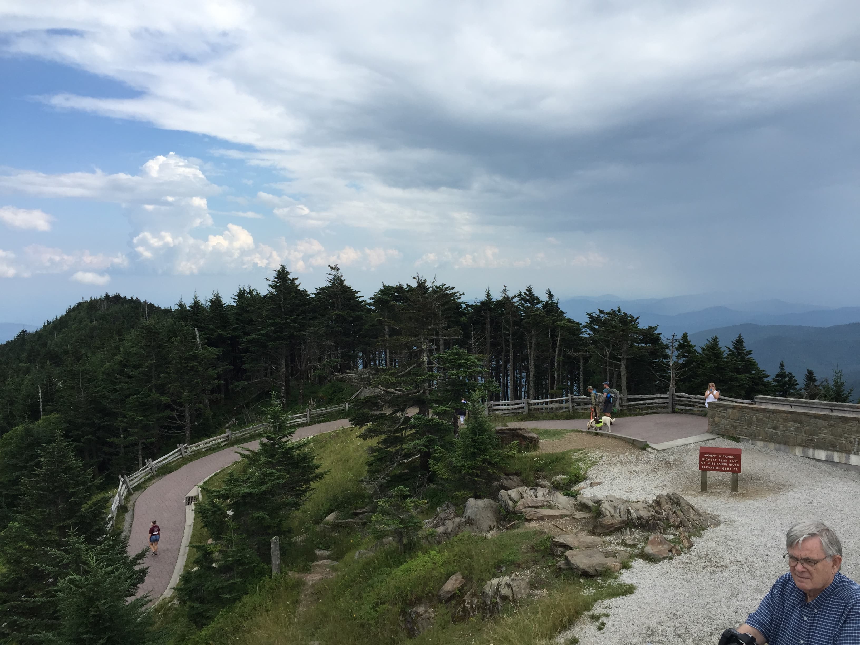
Mount Mitchell
Famartin / openverse (by-sa)
The observation tower's 360-degree platform is best around 4 PM, when long shadows carve the ridgelines into sharp relief.
Summit trail is unpaved and steep in sections; not wheelchair accessible, and benches are sparse near the tower.
Optional detour: Rough Ridge Trail — After Craggy Gardens and before Moses H. Cone Memorial Park
A breezy one-mile ridge-top loop with rare wildflowers and sweeping views into Linville Gorge — ideal if you want one more moderate hike before the estate's easier pace. Skip if: Skip it if fog or storms are rolling in, since the exposed ridge offers zero shelter and the views vanish in poor visibility — or if you'd rather conserve energy for Mount Mitchell's summit push later.
If it rains: If weather turns, shift indoors at Moses H. Cone Memorial Park — the Manor House and craft center are fully operational in rain, with artisans at work and misty mountain views adding atmosphere through the windows. Delay or skip Mount Mitchell if thunderstorms are forecast; lightning risk at that elevation is extreme.

The day begins in soft, cool light at Craggy Gardens, where the couple has the wildflower ridge nearly to themselves before the crowds stir. Purple blooms and wind-bent trees frame a slow, contemplative start — no rush, just the sound of wind and distant birds.

After the quiet drama of the gardens, the pace eases into the cultivated calm of Moses H. Cone's estate, then builds again toward the day's centerpiece: the climb to Mount Mitchell's summit, where thinning air and endless views reward the effort.

With no on-Parkway dining data for this stretch, plan to descend toward Asheville or Blowing Rock for dinner — the mountain towns keep an early rhythm, so aim to be seated by 7 or 8 PM, and let the day's big views settle over a relaxed, unhurried meal.

Wild gorge & waterfall wonder

Day 2: Gorge, Falls, and the Long Golden Drive Home

A moderate day of roughly 2 miles walking, centered on the roar of Linville Falls and a quiet historic viaduct before the drive concludes.

Wear
Waterproof hiking shoes for slick, root-worn trails near the falls, a rain shell in case of spray or showers, and a light layer for the viaduct's open, breezy overlook.
Budget
$60–90 for the couple (Linville Falls and the Viaduct are free to visit; budget for coffee, snacks, and one sit-down meal)
8:00 AM - 9:30 AM
Linville Gorge (Linville Falls) Ā· morning Ā· 90 min Ā· Linville Gorge & Falls

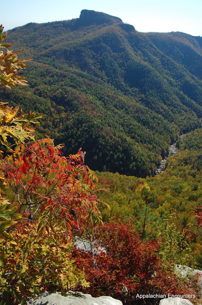
Arrive by 8 AM and the trail is hushed, the roar of the falls echoing off stone walls with no one else in earshot — cool spray on your face, the mineral smell of wet rock, white water exploding against dark granite two thousand feet down. By 10 AM the upper overlook fills with weekend hikers; this early hour is the intimate version of the gorge.

Linville Gorge (Linville Falls)
Appalachian Encounters / openverse (by)
The upper falls overlook offers the full cascade view — come early for soft light and no crowds in frame.
Trails are unpaved and root-worn with steep sections; only the lower observation deck offers limited accessible viewing.
15 min drive — A short hop along the Parkway, gorge views still visible in the rearview mirror as the road curves toward the viaduct.
10:15 AM - 11:00 AM
Viaduct at High Bridge Ā· midday Ā· 45 min Ā· Linville Gorge & Falls

A short, easy contrast after the falls' drama — cool stone underfoot, the distant rush of the river far below, mountain laurel scenting the air. The viaduct's flat, accessible overlook is a place to slow down and simply stand together, watching Victorian-era engineering anchor itself into the forested slopes.

Viaduct at High Bridge
Photo by K on Pexels
The main overlook platform captures the full span of the viaduct; visit before midday tour buses arrive for a clear, quiet shot.
Fully wheelchair accessible with a flat path and frequent benches — the easiest stop of the trip.
Optional detour: Craggy Gardens — Before Linville Gorge (Linville Falls), if driving up from the north on Day 2
A second pass through the wildflower balds catches different light and bloom stages if timing allows, especially if Day 1 was foggy. Skip if: Skip if you already had clear views on Day 1 — repeating a similar high-meadow experience risks overlap fatigue before the gorge's very different, waterfall-driven mood.
If it rains: If rain moves in, the Viaduct at High Bridge remains a reasonable stop from its covered overlook even in light rain, though heavy fog will obscure photography. Linville Falls is dramatic during or just after rain, but trails turn slick — stick to the lower viewing area and skip technical scrambles until conditions clear.

The gorge greets the couple with cool spray and the low thunder of falling water, the trail quiet enough to hear every current below. It's the wildest, most physical stretch of the trip — a fitting counterpoint to yesterday's open meadows and summit air.

The mood softens at the viaduct, where flat paths and stone architecture offer an easy, unhurried close to the outdoor portion of the day — a chance to catch your breath and simply take in the view without exertion.

With no verified dining data directly along this stretch of the Parkway, plan your evening meal in a nearby gateway town such as Linville, Banner Elk, or Blowing Rock — arrive early, as mountain restaurants often close by 9 PM, and let the trip's last dinner be a slow, quiet toast to two days spent above the clouds.

Want to tweak this trip?

Our AI planner can customize this itinerary to your exact dates, interests, and travel style.

Customize This Itinerary
Good to Know

Restaurant details (hours, menus, availability) change frequently, and verified dining options directly on the Parkway are limited — confirm current hours and plan some meals in gateway towns before visiting.

Dietary compatibility tags are general guidance. If you have severe allergies, confirm directly with the restaurant.

Travel tips are general guidance, not professional safety advice. Check government advisories and current Parkway road conditions for the latest information.

All prices are approximate and may vary seasonally.

We use cookies to improve your experience and analyze site usage. Essential cookies are always active. You can customize your preferences or accept all cookies. Cookie Policy