3 DaysActive Retirees6 Stops

Rocky Mountain NP (Trail Ridge Road), Colorado

3-Day Itinerary for Active Retirees

β€œRoof of the Rockies: 3 Gentle Days on Trail Ridge Road”
Roof of the Rockies: 3 Gentle Days on Trail Ridge Road

The air up here is thin enough to feel in your chest, thin enough to make the sky look closer than it has any right to. Trail Ridge Road doesn't rush you toward its wonders β€” it lifts you toward them, curve by curve, until forest gives way to tundra and the whole Continental Divide unfolds without a single flight of stairs.

At a Glance

Climate & Weather
Expect mild days near 45–65Β°F at elevation with much warmer temperatures in Estes Park below, clear morning skies, and near-daily afternoon thunderstorms in July and August. Pack a warm layer, a waterproof windbreaker, sun hat, and sunscreen β€” UV exposure is intense at altitude even on cool days.
Getting Around
A personal vehicle is essential; there's no public transit on Trail Ridge Road itself. Distances between viewpoints are short, but the altitude gain is real β€” drive unhurried, use pullouts liberally, and expect to move at a relaxed pace between clusters.
Budget
Budget roughly $60–100 per person per day for meals and incidentals, plus the park entrance fee (typically valid for 7 days); dining in Estes Park runs $$ for casual sit-down meals.
Safety
The air at 11,000+ feet holds about 30% less oxygen, so move slowly, hydrate often, and treat any headache or dizziness as a signal to descend rather than push through. Afternoon lightning above treeline is the single biggest hazard β€” plan to be off exposed tundra by early afternoon, and keep a respectful distance from elk and marmots.
Connectivity
Cell coverage is spotty to nonexistent along most of the high road and inside the park; Estes Park and Grand Lake have reliable service and WiFi. Download offline maps before setting out each morning.
Local Tips
Arrive at high-elevation viewpoints by 7:30–8am β€” by mid-morning, parking lots fill and the light flattens; also, the Alpine Visitor Center's hours are seasonal (roughly late May–October), so confirm before counting on it as a rest stop.

Highlights

  • Sunrise light on the Continental Divide from Rock Cut's flat boardwalk
  • A gentle half-mile circuit around Sprague Lake with Hallett Peak mirrored on the water
  • Standing at 11,796 feet at the Alpine Visitor Center without breaking a sweat
  • Bear Lake's shoreline stroll beneath granite walls thousands of feet tall
  • Early starts that trade crowds for solitude and softer light
  • Frequent benches and flat boardwalks built into every day's plan
  • Afternoon thunderstorm-savvy pacing that keeps you safely off the tundra by 1pm

Day-by-Day Plan

Orientation & Alpine Wonder

Day 1: First Light on the High Tundra

A gentle introduction to elevation with two short, flat stops along the Trail Ridge Road Scenic Corridor and under a mile of easy walking total.

Wear
Layer up: a warm fleece or light jacket for the summit stops, a waterproof shell in your bag, sturdy walking shoes, sun hat, and sunglasses β€” the sun is fierce at 12,000 feet even when the air feels cool.
Budget
$50-70 per person including park entrance, coffee, and lunch
7:30 AM - 8:15 AM
Rock Cut Β· morning Β· 45 min Β· Trail Ridge Road Scenic Corridor

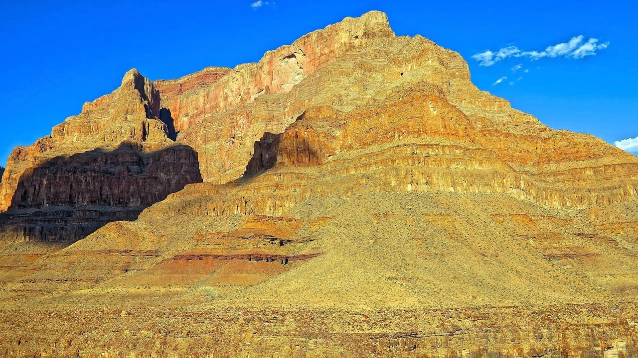
Arrive while the parking area is still nearly empty and the tundra is silvered with early light β€” by 10am this flat boardwalk fills with cars circling for a spot. The walk is level and forgiving, winding through low alpine plants toward a 360-degree wall of granite peaks, with the Continental Divide laid out like something you could reach out and touch. Take it slow; even a short stroll can leave you breathless at this altitude, and that's normal, not alarming.
Rock Cut
Photo by nextvoyage on Pixabay
The main boardwalk overlook faces the Continental Divide β€” soft morning light around 7:30-8am brings out the ridgelines without the midday haze.
Fully wheelchair accessible with a flat boardwalk and frequent benches for resting along the way.
10 min drive β€” A short, winding climb higher still β€” watch for marmots sunning themselves on roadside boulders.
8:30 AM - 9:30 AM
Alpine Visitor Center Β· midday Β· 45 min Β· Trail Ridge Road Scenic Corridor

A short, easy drive brings you to the highest visitor center in the National Park System, where the roof of the Rockies genuinely touches the horizon. Step inside for exhibits on tundra ecology and a warm cup of coffee at the cafe before wandering the short paved paths outside β€” pikas whistle from the rocks and the gift shop bell chimes softly as visitors drift in and out. This is a good spot to rest, use accessible restrooms, and acclimatize before the drive back down.

Alpine Visitor Center
inkknife_2000 (7.5 million views +) / wikimedia (CC BY-SA 2.0)
The west-facing overlook is best saved for a return visit near sunset, but morning light here is still soft and clear for wide tundra shots.
Mostly indoor and paved; wheelchair accessible with benches throughout, making it an easy midday rest point.
Lunch
Trail Ridge Cafe $
Cafe/Coffee Β· At Alpine Visitor Center
A simple, warm spot for coffee and light bites right at the visitor center β€” ideal for resting at altitude without needing to drive back down.
Optional detour: Many Parks Curve β€” After Alpine Visitor Center and before descending for the day
A quick, low-effort hairpin viewpoint with sweeping views across Forest Canyon to the Divide, worth a 15-minute pause on the way down. Skip if: Skip if energy is flagging after the first two stops β€” there are no accessible facilities or benches here, and the views echo what you've already seen at Rock Cut.
If it rains: If afternoon clouds build, retreat into the Alpine Visitor Center for its exhibits and gift shop, then descend Trail Ridge Road promptly β€” lightning risk on exposed tundra is real and the safest move is always to head to lower elevation.

The day begins gently, with an early drive up into thinning air while the road is still quiet. Rock Cut offers the first taste of true tundra β€” flat, easy, and utterly vast, the kind of view that rewards patience rather than exertion.

By midday, the Alpine Visitor Center becomes a welcome pause: a warm coffee, a short indoor browse, and a chance to let the body adjust to altitude before the drive back toward town. There's no rush here β€” the whole point of day one is arrival, not achievement.

Head back down toward Estes Park as the afternoon light softens, settling in for an early, unhurried dinner and a good night's rest before tomorrow's lake walks.

Alpine Lakes & Reflection

Day 2: Mirrors of the Divide

An easy day centered on Bear Lake's flat shoreline loop, with roughly 1.5 miles of gentle walking and plenty of bench stops.

Wear
Comfortable walking shoes with good tread, a light layer for morning cool, and a packable rain shell β€” afternoon showers are common by this cluster's higher elevation.
Budget
$55-80 per person including lunch and park shuttle if used
35 min drive β€” A scenic descent and re-ascent into the Bear Lake corridor, with pine forest closing in after yesterday's open tundra.
7:30 AM - 9:30 AM
Bear Lake Β· morning Β· 120 min Β· Bear Lake & Emerald Lake Corridor

Arrive by 7:30am and the lake is glass-still, Hallett Peak doubled perfectly in the water with barely another soul in sight β€” by mid-morning this becomes one of the park's busiest corners. The main loop trail is unpaved but largely level, threading past reflections and towering granite faces that seem to lean in overhead. Take the walk slowly, pause often at the shoreline, and let the scale of the place settle in rather than rushing the full loop.

Bear Lake
inkknife_2000 (7.5 million views +) / wikimedia (CC BY-SA 2.0)
Shoot from the shoreline in the first hour of light for a still, mirror-like reflection of Hallett Peak β€” wind usually picks up and ripples the water by mid-morning.
The main Bear Lake Loop is mostly flat but unpaved and can be uneven in spots; sturdy shoes recommended, and benches are available but sparse.
Optional detour: Sky Pond Trail β€” Not recommended as a same-day pairing with Bear Lake
For very fit, experienced hikers, this trail leads to a jaw-dropping turquoise alpine lake ringed by permanent snowfields. Skip if: At 8+ hours and intense exertion with significant elevation gain, this is unsuitable for a relaxed-pace itinerary and best left out entirely for this trip.
If it rains: If storms roll in, the shoreline loop at Bear Lake is safer than any higher trail β€” head back to the car at the first sign of thunder, since exposed alpine terrain nearby carries real lightning risk.

The morning is unhurried and reflective, quite literally β€” Bear Lake's still water holds the mountains in place while you walk its edge at whatever pace feels right, pausing on benches whenever the mood strikes.

With the lake loop complete before crowds arrive, the early afternoon is left open for rest back in town; dining options directly at this cluster are limited, so plan your midday meal around Estes Park or Grand Lake rather than the trailhead itself.

Return to your lodging for a quiet evening β€” an easy dinner in town and an early bedtime will make tomorrow's final tundra walk feel just as fresh as the first.

Farewell to the Alpine

Day 3: One Last Easy Mile Above the Clouds

A short, low-exertion final day built around Sprague Lake's fully accessible boardwalk loop, totaling under a mile of walking.

Wear
Light layers, a sun hat, and comfortable shoes β€” this is the flattest, easiest walk of the trip and can be done in relaxed daytime attire.
Budget
$40-60 per person including a farewell lunch
25 min drive β€” A shorter, easier drive than the previous days β€” a fitting last morning commute past increasingly familiar peaks.
8:00 AM - 9:00 AM
Sprague Lake Β· morning Β· 60 min Β· Sprague Lake Loop

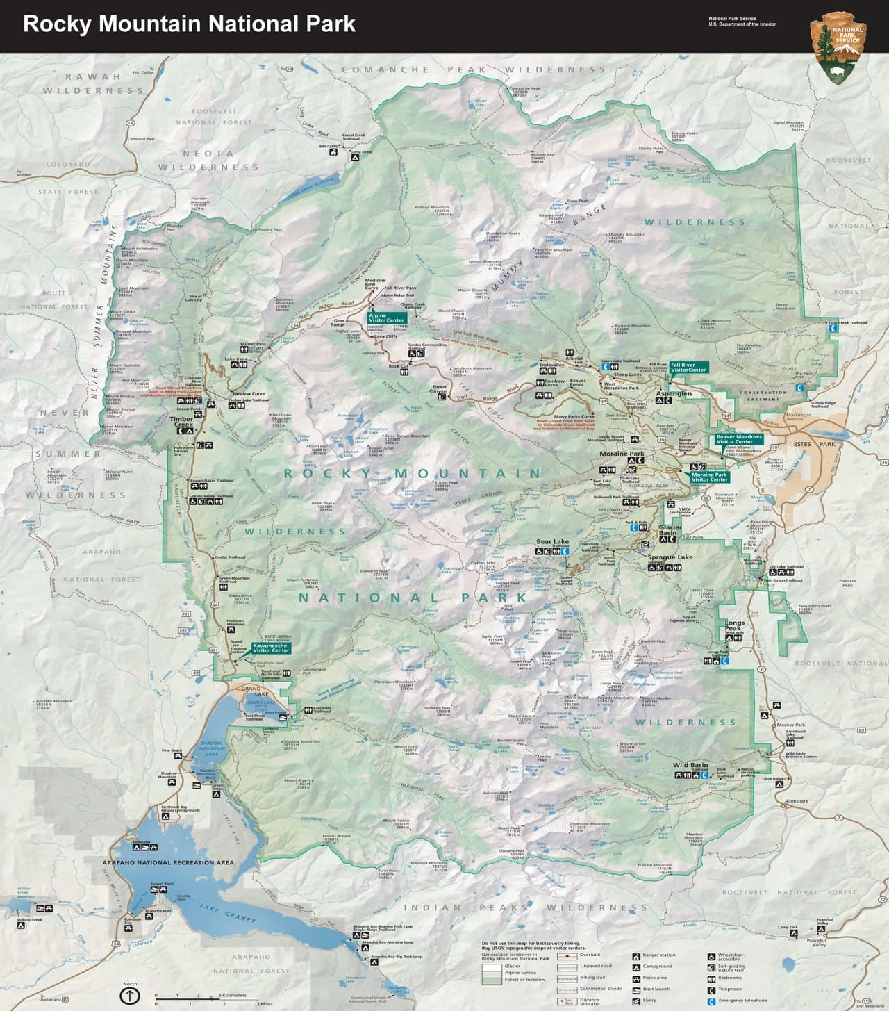
This half-mile boardwalk loop is the most forgiving walk in the entire park, and arriving early means the water is calm enough to hold Flattop and Hallett Peak in near-perfect reflection. Clark's nutcrackers call from the lodgepole pines, and the distant rush of Glacier Creek is the only real sound besides your own footsteps on the boardwalk. Frequent benches make this an ideal, unhurried closing stop β€” sit for a while near the historic dam site, where the crowds thin and the view feels more intimate.

Sprague Lake
U.S. National Park Service, restoration/cleanup by National Park Maps (https://npmaps.com) / wikimedia (Public domain)
The boardwalk midpoint facing Flattop and Hallett Peak is the classic shot β€” best in the first hour after sunrise before wind ripples the surface.
Fully wheelchair accessible boardwalk circuit with frequent benches β€” the easiest, most comfortable walk of the whole trip.
Optional detour: Many Parks Curve β€” On the drive out, after Sprague Lake and before leaving the park
A brief, five-minute pullover for one last wide view of the Divide on the way out, requiring almost no walking. Skip if: Skip if you'd rather head straight to lunch β€” there are no facilities or benches here, and today's pace favors a calm, unhurried departure over another stop.
If it rains: Sprague Lake's boardwalk remains passable in light rain, though peak views will soften; if a downpour sets in, simply shorten the loop to the main overlook section near the parking area.

The final morning asks for nothing strenuous β€” just a slow circuit around Sprague Lake, the easiest and arguably most rewarding walk of the trip, with mountains mirrored so clearly they seem within reach.

With no further hiking planned, the early afternoon is left free for a relaxed lunch in Estes Park or Grand Lake and any last-minute browsing before the drive back toward Denver.

As the light lengthens over the foothills on the drive out, there's little to do but let the last three days settle in β€” tundra wind, still lake water, and the quiet privilege of moving through it all without rushing.

Want to tweak this trip?

Our AI planner can customize this itinerary to your exact dates, interests, and travel style.

Customize This Itinerary
Good to Know

Restaurant details (hours, menus, availability) change frequently. Check current hours before visiting, especially in seasonal destinations.

Dietary compatibility tags are general guidance. If you have severe allergies, confirm directly with the restaurant.

Travel tips are general guidance, not professional safety advice. Check government advisories for latest information.

All prices are approximate and may vary seasonally.
We use cookies to improve your experience and analyze site usage. Essential cookies are always active. You can customize your preferences or accept all cookies. Cookie Policy