3 DaysActive Retirees6 Stops

Great Smoky Mountains (NC side), North Carolina

3-Day Itinerary for Active Retirees

Mist, Elk, and Ancient Ridgelines: 3 Days in the Smokies

Mist, Elk, and Ancient Ridgelines: 3 Days in the Smokies

Here, autumn arrives as a slow exhale—mist pooling in valleys where elk graze like they have for centuries, ridgelines blushing amber and rust under a cooling sun. This is a corner of the Smokies built for unhurried wonder: flat river paths, working grist mills, and views that reward patience rather than exertion.

At a Glance

Climate & Weather
Fall in the NC Smokies means crisp mornings (40s–50s°F) warming to comfortable afternoons (60s°F), with foliage peaking mid-to-late October at higher elevations. Pack layers—fleece, windproof jacket, gloves for summit mornings—plus sturdy walking shoes and a light rain shell for sudden mountain mist.
Getting Around
A personal vehicle is essential; there is no public transit within the park. Distances between clusters range from 20 minutes to just over an hour, with scenic pull-offs along the way. Fill your gas tank in town before entering the park, as services are scarce once inside.
Budget
Budget roughly $70–100 per day per person for meals and modest park-adjacent activities (no park entrance fee is currently required for the Smokies, though a parking tag is needed for stays over 15 minutes).
Safety
Very safe for unhurried exploration; the main concerns are wildlife etiquette (keep 50+ yards from elk, especially during fall rut when bulls are more aggressive) and sudden weather shifts at elevation. Roads are well-maintained but winding—drive slowly and use pull-offs rather than stopping on curves.
Connectivity
Cell service is unreliable to nonexistent inside the park, especially in Cataloochee Valley and along Newfound Gap Road. Download offline maps beforehand and let someone know your general plans each day. Wi-Fi is available at most lodging in Waynesville, Cherokee, and Bryson City.
Local Tips
Arrive at trailheads and overlooks before 9am in fall—weekend crowds build fast during peak foliage, and elk viewing is best at dawn and dusk when animals are most active. Many local restaurants close by 8pm and some shutter on Mondays, so plan dinner reservations accordingly.

Highlights

  • Wild elk grazing at dawn in Cataloochee's hushed valley
  • Standing above the clouds at Clingmans Dome, the AT's highest point
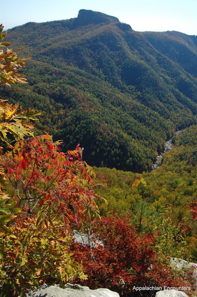
  • 31 miles of ridge-top drama along Newfound Gap Road
  • The rhythmic groan of a 140-year-old water wheel at Mingus Mill
  • Cherokee heritage woven into the Oconaluftee riverbanks
  • Fall foliage layered in blue-hazed mountain ridges
  • Relaxed mountain-town dining after each day's gentle exploration

Day-by-Day Plan

Arrival & Wildlife

Day 1: Elk Valley Mornings and Mountain Stillness

A gentle first day centered on Cataloochee Valley's wild elk and pastoral quiet, with minimal walking (under 1 mile total) to ease into mountain time.

Wear
Layered fleece or light jacket, closed-toe walking shoes, and a warm hat for cool valley mornings—temperatures can be 10 degrees cooler here than in town.
Budget
$60–80 per person (breakfast, lunch, and modest gas for the scenic drive)
8:00 AM - 10:00 AM
Cataloochee Valley (elk) · morning · 120 min · Cataloochee Valley

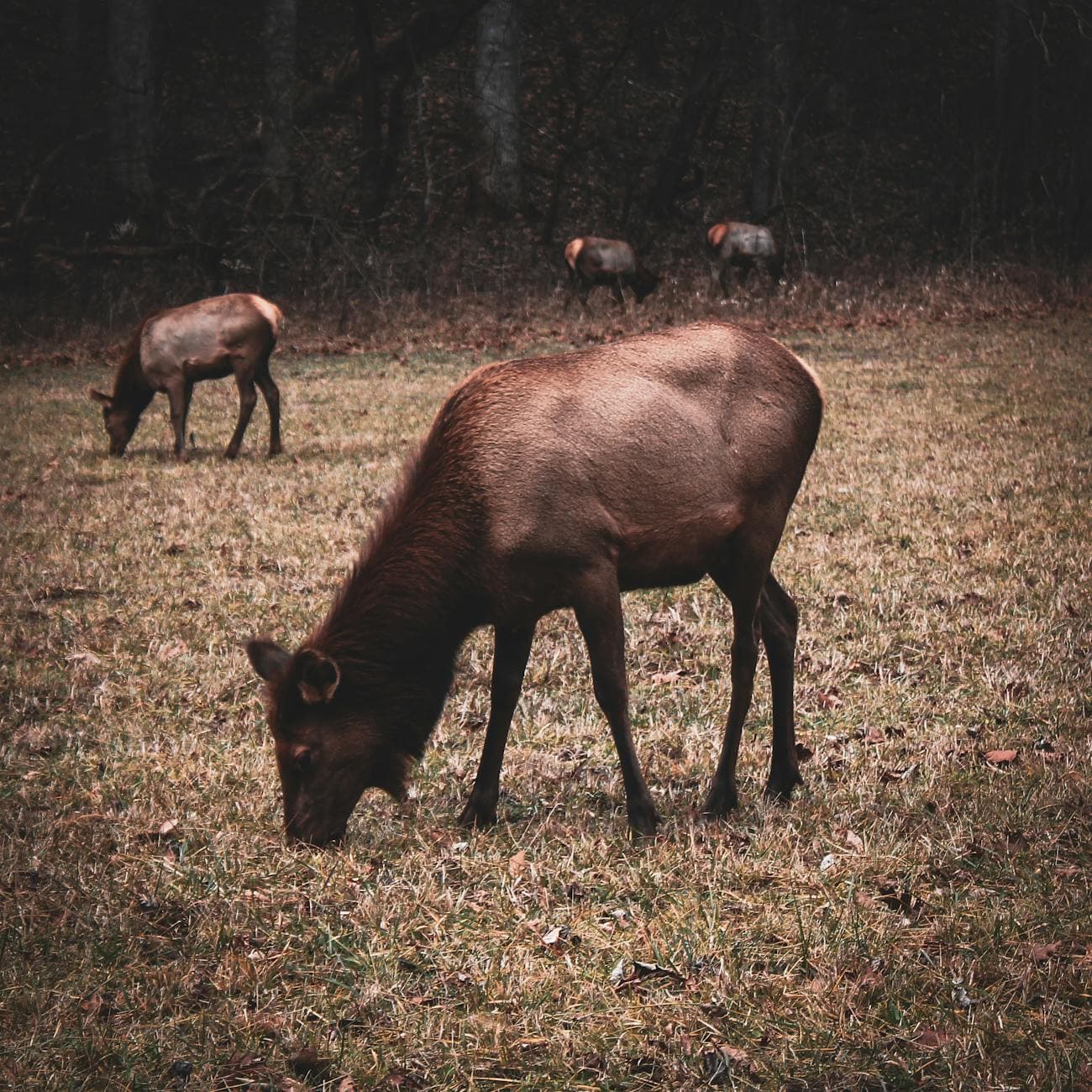
Arrive by 8am and the valley will still be wrapped in mist, elk moving like slow shadows through knee-high grass along Caton Cove Road. There's a hush here—just the occasional distant bugle of a bull elk during fall rut, the crunch of hooves, and cool air scented with damp earth and rhododendron. Bring a lawn chair or simply lean against your car at the Elk Pen Gap overlook; this is a watch-and-wait morning, not a hiking one, and perfectly suited to relaxed observation.

Cataloochee Valley (elk)
Niki Clark / pexels (Pexels License)
Best light is just after sunrise from the Elk Pen Gap overlook, when low sun catches the mist rising off the meadow.
Viewing is roadside and flat near the main pull-offs, though benches are sparse—bring a folding chair if standing for long periods is uncomfortable.
10 min driveA slow crawl along the valley's gravel loop road, windows down, scanning the tree line for one last elk sighting
10:00 AM - 11:00 AM
Cataloochee Valley (elk) · midday · 60 min · Cataloochee Valley

As the sun climbs, drive the loop road toward Palmer Chapel, pausing at the historic homesteads scattered through the valley—weathered barns and a small white chapel that speak to the isolated Appalachian community once here. It's a slower, contemplative continuation of the morning, ideal for those who prefer cultural texture over trail miles.

Cataloochee Valley (elk)
Niki Clark / pexels (Pexels License)
Palmer Chapel framed against the valley backdrop photographs beautifully in soft midday light with the surrounding ridges hazy blue.
Homestead paths are unpaved and slightly uneven; most structures can be viewed from short, flat approaches.
Lunch
Peter's Pancakes & Waffles $
Breakfast/Brunch · Near Oconaluftee, roughly 45 minutes from Cataloochee
A homey, unhurried spot near Oconaluftee worth the drive back toward Cherokee—hearty portions and comfortable seating after a cool valley morning.
If it rains: Elk viewing remains possible in light rain—mist often adds to the atmosphere. In heavier rain, shift focus to the covered viewing areas at the historic homesteads like Palmer Chapel, which can be appreciated at a slower pace regardless of weather.

The valley wakes slowly, mist pooling in low pockets as elk graze unbothered by the handful of early visitors who made the effort to arrive before 8am. There's no rush here—just quiet observation, the occasional far-off bugle, and the particular stillness of a place that has changed little in a hundred years.

As the mist burns off, the pace shifts from wildlife watching to gentle historical wandering—Palmer Chapel and the scattered homesteads offering a window into the families who once called this isolated valley home. It's an easy, flat continuation of the morning's calm.

With the long drive back toward Cherokee or Waynesville, settle into an early dinner—mountain towns wind down by 8pm, so plan to eat by 6 or 6:30. Let day one's slower rhythm set the tone: no rush, just good food and rest before tomorrow's higher elevations.

Summit Views & Scenic Drive

Day 2: Above the Clouds on the Appalachian Spine

A moderate day combining the ridge-top drama of Newfound Gap Road with the iconic (if slightly demanding) summit at Clingmans Dome, totaling roughly 1.5 miles of walking.

Wear
Warm layers are essential—summit temperatures can be 20 degrees cooler than the valley floor, with biting wind at the tower. Wear supportive shoes with good tread for the paved but steep summit path.
Budget
$70–90 per person (lunch, snacks, and gas for the scenic drive)
45 min driveA winding ascent from Cherokee or Waynesville, the air cooling noticeably as elevation climbs and fir trees begin to replace hardwoods
8:30 AM - 10:30 AM
Newfound Gap Road · morning · 120 min · Clingmans Dome High Country

Begin the day with the drive itself as the destination—31 miles of curves revealing layered ridgelines in every shade of blue and, in fall, bursts of amber and crimson. Stop at the Newfound Gap overlook, where North Carolina meets Tennessee, and take in the view without rushing; benches are sparse, so pace your stops accordingly. Arriving by 8:30am means far lighter crowds than the mid-morning rush that builds by 10.

Newfound Gap Road
Photo by Esteban Carriazo on Pexels
The Newfound Gap overlook is best photographed mid-morning when the valley haze has softened but shadows still define the ridgelines.
The main overlooks along Newfound Gap Road are paved and wheelchair accessible, though not perfectly flat in all sections.
15 min driveA short climb up Clingmans Dome Road, ears popping gently as the forest thins into spruce-fir wilderness
11:00 AM - 12:30 PM
Clingmans Dome · midday · 90 min · Clingmans Dome High Country

The paved path to the observation tower is steep—about half a mile each way—so take it slowly, pausing at the frequent benches along the route. At the top, the reward is a 360-degree view above the cloud layer, wind biting and the scent of fraser fir sharp in the cold air; this is the highest point on the entire Appalachian Trail. Active retirees comfortable with a moderate incline will find this manageable at a relaxed pace, though those with mobility concerns may prefer the lower vista points along the bypass trail instead.

Clingmans Dome
Famartin / openverse (by-sa)
Midday sun offers the clearest long-range visibility from the tower; arrive before 11am to beat the thickest crowds forming by early afternoon.
The paved trail to the tower is steep with a grade that may challenge some visitors; benches are placed intermittently for rest stops.
Lunch
Happy Garden Restaurant $
Chinese · Near Oconaluftee, roughly 30 minutes from Clingmans Dome
A comfortable, low-key option near Oconaluftee on the way back down from the high country—quiet seating and quick service after a morning at elevation.
Optional detour: Newfound Gap RoadBetween the Newfound Gap overlook and Clingmans Dome
Additional pull-offs along the road, like the Clingmans Dome Road junction overlook, offer extra photo opportunities without added walking. Skip if: If time is limited or energy is best conserved for the Clingmans Dome summit walk, skip extra stops and proceed directly.
If it rains: If fog or rain descends at elevation, retreat to the lower Newfound Gap area, which often retains visibility even when the summit is socked in. Morning fog frequently lifts by late morning, so a delayed start can also help.

The drive up Newfound Gap Road is itself a kind of meditation—each curve revealing another fold of blue-hazed mountains, fall color deepening as elevation increases. Stopping at the state-line overlook offers a chance to stretch, breathe the thinning air, and take in a view that rarely disappoints.

The pace shifts to something more physical but still manageable: the steep half-mile climb to the Clingmans Dome tower rewards patience with a view unlike any other in the park, wind sharp and clouds sometimes drifting below eye level. This is the day's peak effort, best tackled with frequent rest stops.

Descending back toward Cherokee, the body will feel the elevation change—a good excuse for an early, unhurried dinner and a quiet evening. Reflect on having stood above the clouds, and let tomorrow's gentler pace be a welcome contrast.

Culture & Gentle Wandering

Day 3: Rivers, Mills, and Cherokee Ground

An easy, flat final day exploring the cultural and historic heart of Oconaluftee, with minimal walking (under 1 mile) and rich storytelling at every stop.

Wear
Comfortable layers for cool morning air near the river, light jacket for afternoon warmth, and flat-soled shoes suited to paved and gravel paths.
Budget
$50–70 per person (breakfast, lunch, and light shopping or donations at historic sites)
30 min driveA relaxed morning drive down from Cherokee or Waynesville, the road hugging the river valley as the sun climbs over the ridgeline
9:00 AM - 9:45 AM
Oconaluftee · morning · 45 min · Oconaluftee Gateway

Start gently at the Oconaluftee overlook, where the river runs cool and clear beneath towering hemlocks, mist often still rising off the water in early light. This flat, accessible stop is a perfect low-key opener—benches are sparse, but the paved paths make for easy standing and short strolls along the riverbank.

Oconaluftee
James St. John / openverse (by)
Morning light around 9am catches mist rising off the river beautifully, especially from the US 441 bridge crossing.
Fully wheelchair accessible with flat paved paths and river views close to the parking area.
10 min driveA brief hop along the park road, hemlocks thickening as you approach the mill's shaded creekside setting
10:00 AM - 11:00 AM
Mingus Mill · midday · 60 min · Oconaluftee Gateway

A short drive brings you to Mingus Mill, where the thunderous turn of a 140-year-old water wheel still grinds corn into flour exactly as it did for mountain settlers. The mill's frequent benches and flat, accessible paths make this an ideal, unhurried stop—linger to watch the machinery, feel the cool spray from the millrace, and take in the smell of fresh-ground grain.

Mingus Mill
Photo by Jteder on Pixabay
Interior shots of the grinding stones benefit from the soft natural light streaming through the mill's windows in late morning.
Fully accessible with flat paths and frequent benches—one of the most comfortable stops in the park for extended standing or sitting.
Lunch
El Cajelito $
Mexican · Near Oconaluftee, roughly 10 minutes from Mingus Mill
A relaxed, casual spot near Oconaluftee offering a nice change of pace after two days of mountain comfort food, with comfortable seating for a leisurely lunch.
Hunt Brothers Pizza $
Pizza · Near Oconaluftee
A casual, no-fuss option if you'd prefer something familiar and quick after a full three days of exploring.
Optional detour: Laurel Falls TrailAfter Mingus Mill and before departure
For those still feeling energetic, the trail offers a rewarding waterfall view and is one of the more accessible hikes in the park. Skip if: The trail's uneven, sloped terrain and 1.5-mile round trip may be more strenuous than ideal for a relaxed final day—better suited to those wanting one last active outing.
If it rains: Both Oconaluftee's overlook and Mingus Mill remain enjoyable in rain or mist, which often enhances the river's atmosphere; the mill also has covered viewing areas for shelter during heavier downpours.

The final morning begins softly, river mist curling above the Oconaluftee as early light filters through hemlock and rhododendron. It's a gentle, grounding start—flat paths, quiet water sounds, and a chance to simply breathe in three days' worth of mountain air before the trip winds down.

At Mingus Mill, history turns tactile: the rumble of the water wheel, the smell of ground corn, the cool mist off the millrace. It's a slow, sensory close to the cultural thread that's run through the whole trip—Cherokee heritage, mountain settlers, and the land that shaped them both.

With an easy lunch nearby and no rush to the next stop, let the afternoon fade into a relaxed departure—perhaps one last coffee overlooking the river, reflecting on elk-filled mornings, summit winds, and the quiet rhythm of these ancient mountains.

Want to tweak this trip?

Our AI planner can customize this itinerary to your exact dates, interests, and travel style.

Customize This Itinerary
Good to Know

Restaurant details (hours, menus, availability) change frequently. Check current hours before visiting, especially in seasonal destinations.

Dietary compatibility tags are general guidance. If you have severe allergies, confirm directly with the restaurant.

Travel tips are general guidance, not professional safety advice. Check government advisories for latest information.

All prices are approximate and may vary seasonally.

We use cookies to improve your experience and analyze site usage. Essential cookies are always active. You can customize your preferences or accept all cookies. Cookie Policy